McKean, Pennsylvania facts for kids
Quick facts for kids
McKean
|
|
|---|---|
|
Borough
|
|

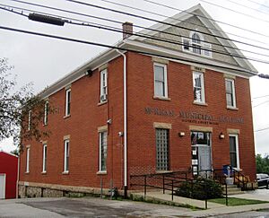
McKean Borough Hall
|
|

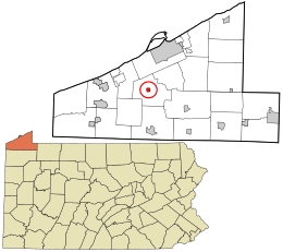
Location in Erie County and the U.S. state of Pennsylvania.
|
|
| Country | United States |
| State | Pennsylvania |
| County | Erie |
| Area | |
| • Total | 0.58 sq mi (1.51 km2) |
| • Land | 0.57 sq mi (1.48 km2) |
| • Water | 0.01 sq mi (0.03 km2) |
| Elevation
(Borough benchmark)
|
1,022 ft (312 m) |
| Highest elevation
(southeast corner of borough)
|
1,200 ft (400 m) |
| Lowest elevation | 985 ft (300 m) |
| Population
(2020)
|
|
| • Total | 476 |
| • Density | 832.17/sq mi (321.38/km2) |
| Time zone | UTC-4 (EST) |
| • Summer (DST) | UTC-5 (EDT) |
| ZIP code |
16426
|
| Area code(s) | 814 |
McKean is a small town, called a borough, located in Erie County, Pennsylvania. In 2020, about 475 people lived there. It's part of a larger area that includes the cities of Erie and Meadville. Before 1970, McKean was actually known by a different name: "Middleboro"!
Contents
Where is McKean Located?
McKean is found in the middle of Erie County. It is completely surrounded by McKean Township.
Getting Around McKean
A main road, Pennsylvania Route 99, goes right through McKean.
- If you go north on Route 99, you'll reach the edge of Erie in about 5 miles.
- If you go south, you'll get to Edinboro in about 8 miles.
Another big highway, Interstate 79, is about 1 mile west of McKean. You can get on it from Exit 174.
- Interstate 79 goes north about 12 miles to downtown Erie.
- It goes south about 27 miles towards the Meadville area.
Water Features in McKean
McKean borough covers about 0.58 square miles (1.5 square kilometers). A small part of this area, about 1.82%, is water. The borough is located along Elk Creek. This creek flows west and eventually empties into Lake Erie.
Who Lives in McKean?
The number of people living in McKean has changed over the years. Here's a quick look at the population from different census counts:
| Historical population | |||
|---|---|---|---|
| Census | Pop. | %± | |
| 1870 | 126 | — | |
| 1880 | 210 | 66.7% | |
| 1890 | 195 | −7.1% | |
| 1900 | 207 | 6.2% | |
| 1910 | 207 | 0.0% | |
| 1920 | 239 | 15.5% | |
| 1930 | 291 | 21.8% | |
| 1940 | 320 | 10.0% | |
| 1950 | 379 | 18.4% | |
| 1960 | 442 | 16.6% | |
| 1970 | 462 | 4.5% | |
| 1980 | 465 | 0.6% | |
| 1990 | 418 | −10.1% | |
| 2000 | 389 | −6.9% | |
| 2010 | 388 | −0.3% | |
| 2020 | 475 | 22.4% | |
| 2021 (est.) | 482 | 24.2% | |
| Sources: | |||
Population Details (2000 Census)
In the year 2000, there were 389 people living in McKean. They lived in 150 different homes, and 100 of these were families.
- About 38% of the homes had children under 18 living there.
- The average home had about 2.57 people.
- The average family had about 3.17 people.
The people in McKean were of different ages:
- 28% were under 18 years old.
- 10.3% were between 18 and 24.
- 25.7% were between 25 and 44.
- 23.7% were between 45 and 64.
- 12.3% were 65 years old or older.
The median age in McKean was 37 years old. This means half the people were younger than 37 and half were older.
Famous People from McKean
- Jack Stauber: He is a well-known musician, animator, and internet personality.
See also
 In Spanish: McKean (Pensilvania) para niños
 | Sharif Bey |
 | Hale Woodruff |
 | Richmond Barthé |
 | Purvis Young |

