North East, Pennsylvania facts for kids
Quick facts for kids
North East, Pennsylvania
|
|
|---|---|
|
Borough
|
|

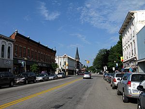
Main Street, looking west toward Lake Street (Pennsylvania Route 89)
|
|
| Etymology: North East Township | |

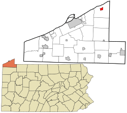
Location in Erie County and the U.S. state of Pennsylvania.
|
|
| Country | United States |
| State | Pennsylvania |
| County | Erie |
| Settled | 1794 |
| Incorporated | February 27, 1834 |
| Founded by | Joseph Shadduck |
| Area | |
| • Total | 1.30 sq mi (3.37 km2) |
| • Land | 1.30 sq mi (3.37 km2) |
| • Water | 0.00 sq mi (0.00 km2) |
| Elevation
(Borough benchmark)
|
802 ft (244 m) |
| Highest elevation
(southeast corner of borough)
|
870 ft (270 m) |
| Lowest elevation
(unnamed tributary to Lake Erie)
|
740 ft (230 m) |
| Population
(2020)
|
|
| • Total | 4,106 |
| • Density | 3,151.19/sq mi (1,216.77/km2) |
| Time zone | UTC-4 (EST) |
| • Summer (DST) | UTC-5 (EDT) |
| ZIP code |
16428
|
| Area code(s) | 814 |
North East is a small town, called a borough, located in Erie County, Pennsylvania, United States. It's about 14 miles (23 km) northeast of the city of Erie. The town gets its name because it's in the northeastern part of Erie County. It is the northernmost town in Pennsylvania.
In 2020, about 4,114 people lived in North East. This area is famous for growing fruits, especially cherries and grapes. Every summer, there's an exciting Cherry Festival, and in the autumn, people celebrate with a Wine Country Harvest Festival.
Contents
History of North East
Early Settlements and Native American Tribes
Before the 1650s, the area where North East is now was home to the Eriez tribe. They were known as a peaceful group. However, the Seneca tribe later took over the area.
In 1792, this land became part of Pennsylvania. The first settlers arrived in North East in 1794. This was even before Erie County and North East Township were officially set up.
Town Development and Name Changes
The first person recorded to settle in this region was Joseph Shadduck from Vermont in 1795. The land that became the borough was first bought by a Mr. Brown, then sold to a land investor named Mr. Gibson.
William Dundas was the first to settle in the borough area. His property was later sold in 1806 to Henry Burgett. Burgett turned the building into a tavern. This spot is believed to be where the first religious ceremony, called the Lord's Supper, happened in Erie County on September 27, 1801.
The town was first called Burgettstown. In 1819, its name changed to Gibsonville. Finally, in 1834, it was officially made a borough and named North East.
Education and Important Events
The first school in North East was started in 1798. Later, in 1870, the first high school, called Lake Shore Seminary, was built. This was a joint effort by the Methodist and Presbyterian Churches.
In 1884, a big fire destroyed two-thirds of the town's business area. This was a major setback for the community.
Two important buildings in North East are listed on the National Register of Historic Places. Short's Hotel was added to the list in 1983. In 1990, the entire old central business district was also added. This means these places are important for their history and are protected.
Geography of North East
North East is located in the northeastern part of Erie County. It is completely surrounded by North East Township.
The borough has a total area of about 3.4 square kilometers (1.3 square miles). All of this area is land.
People of North East
| Historical population | |||
|---|---|---|---|
| Census | Pop. | %± | |
| 1850 | 387 | — | |
| 1860 | 566 | 46.3% | |
| 1870 | 900 | 59.0% | |
| 1880 | 1,396 | 55.1% | |
| 1890 | 1,538 | 10.2% | |
| 1900 | 2,068 | 34.5% | |
| 1910 | 2,672 | 29.2% | |
| 1920 | 3,481 | 30.3% | |
| 1930 | 3,670 | 5.4% | |
| 1940 | 3,704 | 0.9% | |
| 1950 | 4,247 | 14.7% | |
| 1960 | 4,217 | −0.7% | |
| 1970 | 3,846 | −8.8% | |
| 1980 | 4,568 | 18.8% | |
| 1990 | 4,617 | 1.1% | |
| 2000 | 4,601 | −0.3% | |
| 2010 | 4,294 | −6.7% | |
| 2020 | 4,114 | −4.2% | |
| 2021 (est.) | 4,079 | −5.0% | |
| Sources: | |||
Based on the census from 2000, there were 4,601 people living in North East. There were 1,730 households, which are groups of people living together in one home.
About 35.7% of these households had children under 18 living with them. Many households were married couples living together (48.9%). About 14.4% of households had a female head with no husband present.
The population was spread out by age. About 27.5% of the people were under 18 years old. About 13.9% were 65 years or older. The average age in the borough was 34 years.
Culture and Attractions
North East is home to the Lake Shore Railway Museum. This museum is located in the town's old railroad station. It's a great place to learn about trains and railway history.
Schools in North East
The North East School District serves the students in the area. It includes several schools:
- Earle C. Davis Primary School
- Intermediate Elementary School
- North East Middle School
- North East High School
From 1991 to 2021, a college branch called Mercyhurst North East also operated in the town. It was part of Mercyhurst University.
Notable People from North East
Many interesting people have come from North East, Pennsylvania. Here are a few:
- Cooper Boone, a country music artist.
- Samuel Myron Brainerd, who served in the United States House of Representatives.
- Julius C. Burrows, who was both a U.S. Representative and a U.S. Senator for Michigan.
- Frank Hamilton Cushing, an anthropologist who studied different cultures.
- Winifred Davidson, a writer of children's short stories and poetry.
- Laura de Force Gordon, a lawyer, newspaper publisher, and a strong supporter of women's right to vote (a suffragette).
- Ish Kabibble, a famous comedian and cornet player.
- Halli Reid, the first woman to swim all the way across Lake Erie.
Images for kids
See also
 In Spanish: North East (Pensilvania) para niños
 | Selma Burke |
 | Pauline Powell Burns |
 | Frederick J. Brown |
 | Robert Blackburn |


