42nd parallel north facts for kids
The 42nd parallel north is like an imaginary line drawn around the Earth. It's located 42 degrees north of the equator, which is another imaginary line that circles the middle of our planet. This special line goes across many parts of the world, including Europe, the Mediterranean Sea, Asia, the Pacific Ocean, North America, and the Atlantic Ocean.
If you were on the 42nd parallel, the sun would be visible for about 15 hours and 15 minutes during the longest day of summer (the summer solstice). In winter, during the shortest day (the winter solstice), the sun would be visible for about 9 hours and 6 minutes.
Contents
Where the 42nd Parallel Goes
This imaginary line travels across many different countries and bodies of water. Let's explore some of the places it crosses, starting from the Prime Meridian (the line of 0 degrees longitude) and heading east.
Across Europe and Asia
The 42nd parallel starts in Spain, then crosses the Mediterranean Sea to Corsica, an island that belongs to France. It then goes over Italy, passing just north of Rome. After that, it crosses the Adriatic Sea and moves into countries like Montenegro, Albania, Kosovo (which some countries see as part of Serbia), North Macedonia (going through its capital, Skopje), and Bulgaria.
It also touches Turkey in a few spots before crossing the Black Sea. From there, it enters Georgia and a small part of Russia (in Dagestan). The line then crosses the Caspian Sea and continues through many countries in Central Asia, such as Kazakhstan, Turkmenistan, Uzbekistan, and Kyrgyzstan.
In Asia, the 42nd parallel crosses a large part of China, including regions like Xinjiang and Inner Mongolia. It also passes through Mongolia and then goes back into China. Finally, it crosses into North Korea, passing through Heaven Lake on Baekdu Mountain, and then briefly back into China before reaching the Sea of Japan.
Across the Pacific and North America
After crossing the Sea of Japan, the 42nd parallel reaches Japan, specifically the island of Hokkaidō. Then, it stretches across the vast Pacific Ocean.
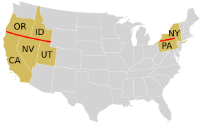
When it reaches North America, the 42nd parallel forms important borders in the United States. It marks the border between Oregon and California, and also between Oregon and Nevada. It continues to define the borders of Idaho with Nevada and Utah.
The line then crosses through several other U.S. states, including Wyoming, Nebraska, Iowa (passing through Cedar Rapids), and Illinois (going through Chicago). It then crosses Lake Michigan and enters Michigan. After that, it crosses Lake Erie and briefly touches Canada in Ontario, at places like Point Pelee National Park.
Back in the United States, the 42nd parallel forms most of the border between New York and Pennsylvania. It also crosses Connecticut, Rhode Island, and Massachusetts, before finally heading out into the Atlantic Ocean. It briefly touches Spain and Portugal before completing its journey back to the Prime Meridian.
The 42nd Parallel in the United States
The 42nd parallel is very important for defining state borders in the U.S. For example, it makes up most of the border between New York and Pennsylvania. However, because of old surveys done a long time ago (in 1785–1786), this border isn't perfectly straight on the true parallel. The area around this border is sometimes called the Twin Tiers.
This parallel also became a key boundary for the Spanish Empire in 1819. A treaty called the Adams–Onís Treaty set the 42nd parallel as the northern border for Spain's lands in North America, separating them from the western territories of the United States. Later, in 1848, the Treaty of Guadalupe Hidalgo meant that a lot of what was then northern Mexico became part of the United States. Because of this, the northern borders of states like California, Nevada, and Utah are set by the 42nd parallel. And, of course, the states of Oregon and Idaho have the 42nd parallel as their southern border.
The 42nd parallel also passes through or very close to many cities in the United States, such as:
- Crescent City, California
- Yreka, California
- Hartford, Connecticut
- Ames, Iowa
- Chicago, Illinois
- Kalamazoo, Michigan
- Erie, Pennsylvania
- Jamestown, New York
- Binghamton, New York
- Plymouth, Massachusetts
- Springfield, Massachusetts
- Worcester, Massachusetts
- Ashland, Oregon
- Providence, Rhode Island
The 42nd Parallel in Canada
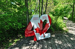
The 42nd parallel north crosses the southern parts of Lake Michigan and Lake Erie. A small part of the water border between Canada and the United States actually goes south of this parallel. The very southern tip of the Canadian province of Ontario extends just south of the 42nd parallel at places like Point Pelee and Pelee Island. Also, a small part of the Town of Essex in Ontario, near Colchester, is located below the 42nd parallel.
See also
- 41st parallel north
- 43rd parallel north
- The Twin Tiers region of New York and Pennsylvania
 | Selma Burke |
 | Pauline Powell Burns |
 | Frederick J. Brown |
 | Robert Blackburn |


