
Yreka, California facts for kids
Quick facts for kids
Yreka, California
|
|
|---|---|
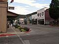
.JPG)
Downtown Yreka in 2011
|
|

Location in Siskiyou County and the state of California
|
|

Yreka, California
Location in California

Yreka, California
Location in the United States
|
|
| Country | United States |
| State | California |
| County | Siskiyou |
| Incorporated | April 21, 1857 |
| Government | |
| • Type | Council–manager |
| Area | |
| • Total | 10.06 sq mi (26.05 km2) |
| • Land | 9.98 sq mi (25.86 km2) |
| • Water | 0.07 sq mi (0.19 km2) 0.72% |
| Elevation | 2,589 ft (789 m) |
| Population
(2020)
|
|
| • Total | 7,827 |
| • Density | 752.9/sq mi (290.70/km2) |
| Time zone | UTC−8 (Pacific) |
| • Summer (DST) | UTC−7 (PDT) |
| ZIP code |
96097
|
| Area code | 530 |
| FIPS code | 06-86944 |
| GNIS feature ID | 1652661 |
Yreka (/waɪˈriːkə/ wy-REE-kə) is a city in Siskiyou County, California. It is the main city of the county, located near the Shasta River. The city covers about 10 square miles (26 km2), mostly land. As of 2022, its population was 7,827. This was a small increase from the 7,765 people counted in the 2010 Census. Yreka is home to the College of the Siskiyous, the Klamath National Forest Interpretive Museum, and the Siskiyou County Museum.
Contents
- Discovering Yreka's Past
- Exploring Yreka's Geography
- Yreka's Climate
- Understanding Yreka's Population
- Yreka's Economy and Tourism
- Learning and Education in Yreka
- Local Media and News
- Getting Around Yreka: Transportation
- Famous People Connected to Yreka
- The "Yreka Bakery" Palindrome
- Images for kids
- See also
Discovering Yreka's Past
In March 1851, a traveler named Abraham Thompson found gold near Rocky Gulch. He was on the Siskiyou Trail coming from southern Oregon. By April 1851, about 2,000 miners had rushed to "Thompson's Dry Diggings." They hoped to find their own gold.
By June 1851, a busy gold rush town had quickly grown. It was made of tents, shacks, and a few simple cabins. The little city's name changed a few times until it became Yreka. The name comes from the Shasta language word /wáik'a/. This word is also where Mount Shasta gets its name. It means "north mountain" or "white mountain."
A Funny Story About the Name
The famous writer Mark Twain shared a different story about how Yreka got its name. He said that in the 1850s, a young man named Harte came to California. Harte explored the gold digging camps in Yreka. The town needed a name in its early days.
There was a bakery with a canvas sign that was not yet put up. It had been painted and was drying. The word "BAKERY" was painted on it. But all the letters except the "B" showed through and were reversed. A stranger read it backward, seeing "YREKA." He thought that was the name of the camp. The people living there liked it and decided to use it.
Yreka's Early Days
Poet Joaquin Miller described Yreka in 1853–1854. He said it was a very busy place. There was "a tide of people up and down and across other streets." It was as busy as a big city on the East Coast. Yreka officially became a city on April 21, 1857.
The State of Jefferson Idea
In November 1941, Yreka was chosen as the capital for a new proposed state. This idea was called the State of Jefferson. It was a movement to create a new state along the border of Oregon and California.
Exploring Yreka's Geography
Yreka is located about 2,500 feet (760 m) above sea level. It sits in the Shasta Valley. This valley is south of the Siskiyou Mountains. To the north is Mount Shasta, a 14,000 ft (4,300 m) dormant volcano. This huge volcano stands tall over the valley.
The United States Census Bureau says the city covers 10.1 sq mi (26 km2) in total. Most of this area, 10.0 square miles (26 km2), is land. Only a small part, 0.1 square miles (0.26 km2) (0.72%), is water.
Local Plants and Flowers

The official city flower of Yreka is the Yreka phlox (Phlox hirsuta).
In June 1876, a botanist named Edward Lee Greene found a rare flower near Yreka. It was the only known specimen of Calochortus monanthus, also called the single-flowered mariposa lily. He found it along the banks of the Shasta River.
Cities and Towns Near Yreka
Here are some places close to Yreka:
- Montague: 6.4 miles (10.3 km) to the east
- Grenada: 11.5 miles (18.5 km) to the southeast
- Fort Jones: 17.2 miles (27.7 km) to the southwest
- Klamath River: 24.3 miles (39.1 km) to the northwest
- Hornbrook: 15.1 miles (24.3 km) to the north
Yreka's Climate
Yreka has a hot-summer Mediterranean climate (Csa). This means it has hot, dry summers and mild, wet winters. It almost has a warm-summer Mediterranean climate (Csb).
| Climate data for Yreka, California | |||||||||||||
|---|---|---|---|---|---|---|---|---|---|---|---|---|---|
| Month | Jan | Feb | Mar | Apr | May | Jun | Jul | Aug | Sep | Oct | Nov | Dec | Year |
| Record high °F (°C) | 66 (19) |
74 (23) |
81 (27) |
96 (36) |
103 (39) |
109 (43) |
112 (44) |
110 (43) |
107 (42) |
95 (35) |
87 (31) |
66 (19) |
112 (44) |
| Mean daily maximum °F (°C) | 45.9 (7.7) |
51.4 (10.8) |
58.0 (14.4) |
63.8 (17.7) |
73.2 (22.9) |
81.8 (27.7) |
91.8 (33.2) |
91.2 (32.9) |
83.1 (28.4) |
70.0 (21.1) |
52.8 (11.6) |
44.7 (7.1) |
67.3 (19.6) |
| Daily mean °F (°C) | 35.4 (1.9) |
39.0 (3.9) |
44.0 (6.7) |
48.9 (9.4) |
56.7 (13.7) |
63.9 (17.7) |
71.8 (22.1) |
70.8 (21.6) |
63.5 (17.5) |
52.7 (11.5) |
40.8 (4.9) |
34.6 (1.4) |
51.8 (11.0) |
| Mean daily minimum °F (°C) | 24.9 (−3.9) |
26.5 (−3.1) |
29.9 (−1.2) |
33.9 (1.1) |
40.1 (4.5) |
45.9 (7.7) |
51.7 (10.9) |
50.4 (10.2) |
43.8 (6.6) |
35.3 (1.8) |
28.8 (−1.8) |
24.4 (−4.2) |
36.3 (2.4) |
| Record low °F (°C) | −11 (−24) |
−11 (−24) |
0 (−18) |
17 (−8) |
20 (−7) |
26 (−3) |
34 (1) |
33 (1) |
20 (−7) |
7 (−14) |
1 (−17) |
−11 (−24) |
−11 (−24) |
| Average precipitation inches (mm) | 3.09 (78) |
2.07 (53) |
1.63 (41) |
1.27 (32) |
1.31 (33) |
.97 (25) |
.55 (14) |
.36 (9.1) |
.54 (14) |
1.11 (28) |
2.92 (74) |
3.97 (101) |
19.79 (503) |
| Average snowfall inches (cm) | 3.7 (9.4) |
2.6 (6.6) |
.9 (2.3) |
.2 (0.51) |
0 (0) |
0 (0) |
0 (0) |
0 (0) |
0 (0) |
.1 (0.25) |
1.3 (3.3) |
3.7 (9.4) |
12.4 (31) |
| Average precipitation days (≥ 0.01 in) | 13.2 | 9.7 | 10.3 | 8.7 | 7.6 | 4.6 | 3.0 | 2.5 | 2.7 | 5.3 | 11.4 | 12.7 | 91.7 |
| Average snowy days (≥ 0.1 in) | 2.0 | 1.2 | .5 | .2 | 0 | 0 | 0 | 0 | 0 | 0 | .8 | 1.8 | 6.7 |
| Source: NOAA | |||||||||||||
Understanding Yreka's Population
| Historical population | |||
|---|---|---|---|
| Census | Pop. | %± | |
| 1860 | 1,327 | — | |
| 1870 | 1,063 | −19.9% | |
| 1880 | 1,059 | −0.4% | |
| 1890 | 1,100 | 3.9% | |
| 1900 | 1,254 | 14.0% | |
| 1910 | 1,134 | −9.6% | |
| 1920 | 1,277 | 12.6% | |
| 1930 | 2,126 | 66.5% | |
| 1940 | 2,485 | 16.9% | |
| 1950 | 3,227 | 29.9% | |
| 1960 | 4,759 | 47.5% | |
| 1970 | 5,394 | 13.3% | |
| 1980 | 5,916 | 9.7% | |
| 1990 | 6,948 | 17.4% | |
| 2000 | 7,290 | 4.9% | |
| 2010 | 7,765 | 6.5% | |
| 2020 | 7,807 | 0.5% | |
| U.S. Decennial Census | |||
Yreka's Population in 2010
The 2010 United States Census showed that Yreka had 7,765 people. This meant there were about 772.5 people per square mile. Most of the people, 6,495 (83.6%), were White. There were also 491 (6.3%) Native American people. About 753 people (9.7%) were Hispanic or Latino.
Almost everyone, 7,718 people (99.4%), lived in homes. There were 3,394 households in total. About 983 (29.0%) of these homes had children under 18. The average household had 2.27 people. The average family had 2.92 people.
The population included 1,871 young people (24.1%) under 18. There were 1,494 people (19.2%) who were 65 or older. The average age in Yreka was 41.7 years. For every 100 females, there were about 89.5 males.
There were 3,675 housing units in Yreka. About 1,751 (51.6%) of these homes were owned by the people living in them. The other 1,643 (48.4%) were rented.
Yreka's Population in 2000
In the 2000 census, Yreka had 7,290 people. There were 3,114 households and 1,880 families. The city had about 730.8 people per square mile. Most people were White (86.6%). Native American people made up 6.0% of the population. About 5.4% of the people were Hispanic or Latino.
About 29.4% of households had children under 18. The average household size was 2.27 people. The average family size was 2.92 people.
The population included 25.5% under 18 years old. About 19.4% were 65 years or older. The average age was 41. For every 100 females, there were about 88.3 males.
The average income for a household was $27,398. For a family, it was $37,448. About 17.5% of families and 21.2% of the total population lived below the poverty line. This included 33.6% of those under 18.
Yreka's Economy and Tourism
|
West Miner Street-Third Street District
|
|

West Miner Street in Yreka
|
|
| Built | 1854–1900 |
|---|---|
| NRHP reference No. | 72000258 |
| Significant dates | |
| Added to NRHP | December 11, 1972 |

Many tourists visit Yreka because it is at the northern edge of the Shasta Cascade area. This area is known for its beautiful nature. The historic downtown area, especially along West Miner Street, is a special place. It is listed as a historic district.
Yreka is home to the Siskiyou County Museum. It also has many monuments and parks from the Gold Rush era. Visitors also come to fish for trout in nearby rivers. These include the Klamath, Sacramento, and McCloud Rivers. People also visit to see and climb Mount Shasta or Castle Crags.
Visitors can also enjoy skiing, biking, or hiking. There are many waterfalls, streams, and lakes in the area. Some popular spots are Falls of the McCloud River, Burney Falls, Mossbrae Falls, Lake Siskiyou, Castle Lake, and Shasta Lake.
The town celebrates its history every year with "Gold Rush Days" in June.
Since Yreka is the county seat of Siskiyou County, many businesses related to county services are located here. These include the county courts and other official county offices. The Butte Valley National Grassland is also managed from offices in Yreka.
Learning and Education in Yreka
Yreka has a campus of the College of the Siskiyous. This college offers programs like the Rural Health Science Institute. It also has Administration of Justice programs. It is one of only 10 community colleges in California that offer on-campus housing for students. High school buses bring students from smaller towns to Yreka. This helps students get a secondary education when their own towns might not have a high school.
The gold-mining era is remembered in Yreka with a gold museum. There is also a reminder of a silver mining operation in Greenhorn Park. The Yreka Union High School District's sports mascot is a gold miner. The school colors are red and gold. Yreka High School was the first high school in the county. It was founded in 1894. It serves students from 11 smaller school districts in the county area, which covers about 1,200 square miles (3,100 km2).
The Yreka elementary school district includes Evergreen Elementary and Jackson Street Middle School.
Local Media and News
Yreka has several local media options:
- KSYC-AM 1490 Jefferson Public Radio (currently not broadcasting)
- KSYC-FM 103.9 Jefferson Public Radio
- KZRO-FM 100.1 Mount Shasta
- KKLC 107.9 K-LOVE, Fall River Mills
- Siskiyou Daily News (local newspaper)
- Vyve Broadband (internet and TV provider)
- YCTV 4 Yreka Community Television/Siskiyou Media Council (local TV)
Getting Around Yreka: Transportation
Interstate 5 is the main road that goes north and south through Yreka. It connects Yreka to Redding and Sacramento to the south. It also connects to the Oregon border to the north. Interstate 5 in Yreka follows the old path of the Siskiyou Trail. This trail used to go from California's Central Valley to Oregon's Willamette Valley.
California State Route 3 goes east to Montague. It goes west to Fort Jones and Weaverville. California State Route 263 is another road that goes through the northern part of the city.
For small planes, people use the Montague Airport. It is in Montague, about 6 miles (9.7 km) to the east.
Public Transportation Options
Siskiyou transit (STAGE) offers public transportation. Route 1, called the Cascade Flyer (Express), serves Yreka three times a day. It also goes through Mt Shasta and Dunsmuir.
Famous People Connected to Yreka
- Erik Bennett, a Major League Baseball player, was born in Yreka.
- Charles Earl Bowles, also known as Black Bart, was an outlaw. He robbed stagecoaches on trails near Yreka in the 1880s.
- Leander Clark, an Iowa state lawmaker and army officer, looked for gold in the Yreka area. He returned home much richer in 1852.
- Edward Silsby Farrington, a United States federal judge, was born in Yreka.
- Marco Grifantini, a baseball player, was born in Yreka.
- William Irwin was a representative for Siskiyou. He later became the governor of California.
- Ross McCloud was the Siskiyou County surveyor in the mid-1850s. He planned many of the trails and roads still used today.
- Tim Meamber, an American football player, was born in Yreka.
- Richie Myers, a baseball player, lived in Yreka when he passed away there.
- John Otto was the first park keeper at Colorado National Monument. He helped create it and have it included in the National Park System. He spent his last 20 years near Yreka.
- Eric Pianka, a biologist, grew up in Yreka.
- Elijah Steele was an early pioneer in Northern California. He was a state lawmaker and tried to prevent the Modoc War. He lived in Yreka when he was a judge for Siskiyou County from 1879 to 1883.
The "Yreka Bakery" Palindrome
"Yreka Bakery" is a special kind of word puzzle called a palindrome. This means it reads the same forwards and backward. The story from Mark Twain mentions how the name Yreka might have come from a bakery sign. The sign had the word "BAKERY" painted on it. If you saw it reversed, without the "B," it looked like "YREKA."
The first Yreka Bakery was started in 1856 by a baker named Frederick Deng. People noticed the palindrome early on. An ad from 1863 said, "spell Yreka Bakery backwards and you will know where to get a good loaf of bread." The bakery moved to its long-time spot at 322 West Miner Street. It stayed there until it closed in 1965. Another Yreka Bakery opened in 1974 but is no longer in business. Today, the historic building at 322–324 West Miner Street has a restaurant.
Images for kids
-
West Miner Street in Yreka
See also
 In Spanish: Yreka para niños
