
McCloud River facts for kids
Quick facts for kids McCloud River |
|
|---|---|

Middle McCloud Falls on the McCloud River
|
|

Location of the mouth of the McCloud River in California
|
|
| Other name(s) | McLeod's Fork, McLoud River |
| Country | United States |
| State | California |
| City | McCloud |
| Physical characteristics | |
| Main source | Southeast of Mount Shasta, Siskiyou County, California 4,677 ft (1,426 m) 41°13′12″N 121°46′21″W / 41.22000°N 121.77250°W |
| River mouth | McCloud River Arm of Lake Shasta, Sacramento River, Shasta County, California 1,066 ft (325 m) 40°46′13″N 122°18′13″W / 40.77028°N 122.30361°W |
| Length | 77 mi (124 km) |
| Basin features | |
| Basin size | 674 sq mi (1,750 km2) |
_on_McCloud_River.jpg)
The McCloud River is a river in northern California, United States. It is about 77 mi (124 km) long. The river flows through Siskiyou County and Shasta County. It runs east of and parallel to the upper Sacramento River.
The McCloud River is special because it's protected by California's Wild and Scenic Rivers Act. This means its natural beauty and wildlife are kept safe. The river flows through a beautiful mountain area called the Cascade Range, including part of Mount Shasta. It eventually joins the Pit River, and both flow into the Sacramento River at Shasta Lake. This lake is formed by the Shasta Dam near Redding.
Contents
River History and Name
The McCloud River was first called the "McLeod River." This name came from Alexander Roderick McLeod, a fur hunter and trapper. He explored the river in the winter of 1829-1830.
By the 1860s, people started spelling the name "McCloud." This was probably because "McCloud" was a common American way to spell the Scottish name. It might also have been to honor Ross McCloud, an early California settler who moved there in 1855.
River Geography
The McCloud River collects water from an area of about 674 square miles (1,750 km2). It starts from several streams fed by springs in Colby Meadows. This area is in the Cascade Range, about 10 miles (16 km) southeast of Mount Shasta in Siskiyou County.
The river first flows west, passing south of Mount Shasta. It collects water from streams that drain the southern side of the mountain. East of McCloud, the river forms a series of beautiful waterfalls. These waterfalls tumble over dark, volcanic rocks called basalt. They are known as the McCloud River Falls.

After the falls, the river generally flows south-southwest. It passes through the Lake McCloud reservoir. Then it goes through a deep canyon in the Shasta-Trinity National Forest. The lower 10 miles (16 km) of the river forms an arm of Shasta Lake. This lake is created by the Shasta Dam. The McCloud arm of the lake joins the Pit River arm near the Pit River Bridge. This is about 5 miles (8.0 km) north of the city of Shasta Lake.
Some of the main streams that flow into the upper McCloud River are Mud Creek and Tate Creek. Below the McCloud Reservoir, important streams include Squaw Valley Creek, Hawkins Creek, Claiborne Creek, and Chatterdown Creek.
River Modifications and Dams
The McCloud River has a dam called the McCloud River Dam. This dam helps provide water for the McCloud-Pit Hydroelectric Project. A hydroelectric project uses the power of moving water to create electricity.
A tunnel called the McCloud Tunnel takes water from the McCloud River. This water is sent east to the Iron Canyon Reservoir. From there, the water flows into the Pit River at the James B. Black Powerhouse. This extra water helps make more electricity at other dams further downstream, like Pit 6 and Pit 7 Dams. All this water then flows into Shasta Lake. This system can create a lot of electricity, about 364 megawatts. The company PG&E owns and runs this system, which was built in the late 1960s.
Because of the dam, the amount of water flowing in the lower McCloud River has changed. The average flow of water has decreased quite a bit, especially during the summer months. However, the dam does not affect the large flows of water that happen in winter. These winter flows mostly come from areas below the dam.
Recreation and Fun Activities
The McCloud River is usually thought of in two parts: the Upper McCloud and the Lower McCloud. The Upper McCloud is the part of the river above the McCloud Reservoir. The Lower McCloud stretches from the reservoir down to Shasta Lake.
The beautiful waterfalls are all found on the Upper McCloud. This part of the river is a popular spot for people who enjoy kayaking. There is a nice campground called Fowlers on the Upper McCloud.
For fishing, the Upper McCloud above the Upper Falls is not often stocked with fish, so finding them can be a fun challenge for experienced anglers. The section from Lower Falls to Upper Falls is stocked with fish and allows bait fishing. The Lower McCloud is mostly for fly fishing or using artificial lures. People are encouraged to practice "catch and release" fishing here. This means you catch the fish, but then you let it go back into the water.
There are also some private fishing clubs on the last few miles of the McCloud River. However, there is a special area run by The Nature Conservancy. This area allows ten fishing rods per day and welcomes hikers and bird watchers. It was a gift from the nearby McCloud River Club.
You can find two campgrounds on the Lower McCloud River: Ash Camp and Ah Di Nah Campground. Ash Camp is a small, simple camping area about 1 mile (1.6 km) downstream from the McCloud Reservoir dam. It has a few campsites and a toilet.
Ah Di Nah Campground is a bit further downstream. It's a Shasta-Trinity National Forest campground, and you pay a fee to camp there overnight. Ah Di Nah is popular with backpackers and anglers. This is because it's close to the Pacific Crest Trail and The Nature Conservancy area on the McCloud River. Bathrooms and water are available at Ah Di Nah.
River Ecology and Wildlife
The McCloud River used to be home to a native fish called the bull trout. However, these fish are no longer found in the McCloud River. This happened after the McCloud Reservoir dam was built, which blocked the fish from reaching their spawning grounds. Spawning grounds are places where fish lay their eggs. The last bull trout was reported in the 1980s.
The Upper McCloud River and its smaller streams above Middle Falls are home to a special fish. This fish is called the McCloud River redband (Oncorhynchus mykiss stonei). It is a native type of rainbow trout. Scientists have suggested that these redband trout should be protected as an endangered species. This is because their unique genes have mixed with genes from rainbow trout that were raised in fish farms and then released into the river.
The Falls of the McCloud River naturally stopped rainbow trout from moving further upstream in the past. Scientists have studied the genes of these fish. Their research shows that the redband trout from Sheepheaven Creek are different enough to be considered a special subspecies. To help protect them, efforts have been made to move pure redband trout from Sheepheaven Creek into other streams like Swamp Creek and Trout Creek.
Gallery
- Images of the McCloud River falls
-
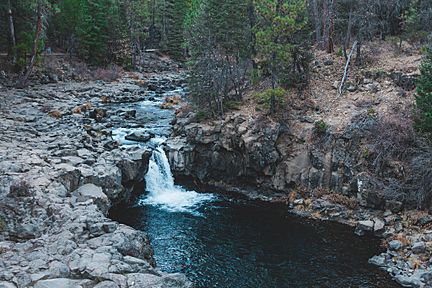
Lower Falls
-
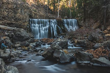
Middle Falls
-
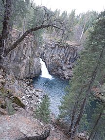
Upper Falls


