
Shasta Lake facts for kids
Quick facts for kids Shasta Lake |
|
|---|---|
 |
|

Shasta Lake
Location in California
|
|
| Location | Shasta-Trinity National Forest Shasta County, California |
| Coordinates | 40°45′37″N 122°22′19″W / 40.7602°N 122.37190°W |
| Type | Reservoir |
| Primary inflows | Sacramento River, Pit River, McCloud River |
| Primary outflows | Sacramento River |
| Basin countries | United States |
| Max. length | 35 mi (56 km) |
| Surface area | 30,000 acres (47 sq mi) |
| Max. depth | 517 ft (158 m) |
| Water volume | 4,552,000 acre⋅ft (5.615 km3) |
| Shore length1 | 365 mi (587 km) |
| Surface elevation | 1,067 ft (325 m) |
| Settlements | Lakehead |
| 1 Shore length is not a well-defined measure. | |
Shasta Lake, also called Lake Shasta, is a huge man-made lake in Shasta County, California, United States. It began to fill with water in 1944. This happened after the Shasta Dam was built across the Sacramento River. The Shasta Dam is the ninth tallest dam in the United States!
Shasta Lake is a very important part of the Central Valley Project. It helps control floods in the Sacramento Valley below the dam. Water flowing out of the dam also creates electricity at the Shasta Powerplant. This water is then used to help grow crops and supply towns.
The lake is located inside the Whiskeytown–Shasta–Trinity National Recreation Area. This area is managed by the Shasta-Trinity National Forest. There are special guidelines for eating fish caught in the lake. These are based on levels of certain chemicals found in local fish.
Contents
About Shasta Lake
Shasta Lake is California's largest man-made lake. It can hold a lot of water, about 4,552,000 acre⋅ft (5.615 km3) when full. The lake sits at an elevation of 1,067 ft (325 m) above sea level. Its surface area covers about 30,000 acres (12,000 ha). It is the third-largest body of water in California, after Lake Tahoe and the Salton Sea.
The lake is about 10 miles (16 km) north of the city of Redding. The town of Lakehead is on its northern shore. Shasta Lake is a popular spot for fun activities like boating, water skiing, camping, houseboating, and fishing. The lake was formed by damming the Sacramento River. It has about 365 mi (587 km) of shoreline. This shoreline is mostly steep and covered with tall evergreen trees and manzanita bushes. The deepest part of the lake is 517 feet (158 m).
The lake has four main "arms," which are like long branches. Each arm is fed by a different river: the Sacramento River, the McCloud River, Squaw Creek, and the Pit River. The Sacramento River starts in the Klamath Mountains. The McCloud River begins near Mount Shasta. The Pit River flows from Alturas. You can find a beautiful waterfall called Potem Falls on the Pit River arm of the lake.
History of the Lake
The Shasta Dam was built between 1935 and 1945 across the Sacramento River. Shasta Lake itself was formed in 1948 when the dam started holding back water. When the lake filled up, it covered the lower parts of the Pit River, McCloud River, and several smaller streams. It also covered the old town of Kennett. Many traditional fishing, hunting, and gathering spots of the Wintun people were also submerged. If the water level is low, you can sometimes see parts of old train tunnels and tracks from the Southern Pacific Transportation Company.
Shasta Lake was once home to a big event called "Boardstock." This event started in 1996 and happened every year until 1999. It brought many professional wakeboard riders from all over the world. About 15,000 people would come to watch. The event lasted for three days each year and featured several wakeboard contests.
Marinas on Shasta Lake
There are many marinas around Shasta Lake. A marina is like a parking lot for boats! They offer different services, including renting out houseboats.
- Bridge Bay Marina is the biggest marina on Shasta Lake. It has over 700 boat slips. You can find a restaurant, a bar, and places to stay there. They also have shops and other services. Visitors can rent one of 100 houseboats, as well as ski boats, fishing boats, patio boats, and personal watercraft like jet skis. Bridge Bay is a busy spot in summer, with a gas dock, food, and ice.
- Digger Bay Marina has over 150 boat slips. It also has a shop and small boat rentals.
- Shasta Marina Resort is located in the middle of the Sacramento Arm of Shasta Lake.
- Packer's Bay Marina is also in the center of the lake, just north of Bridge Bay.
- Antler's Marina is the northernmost marina on Shasta Lake.
- Silverthorn Marina is on the east side of the lake. They offer large houseboats for rent.
- Jones Valley Resort is the easternmost marina on the lake. It's tucked into a quiet cove and has six different types of rental houseboats, including the biggest one on the lake, called the Titan.
- Holiday Harbor is located up the McCloud River Arm, east of the I-5 highway.
- Sugarloaf Marina is located up the Sacramento River Arm. It has a marina store, overnight slips for boats, and fuel.
Shasta Lake's Climate
Shasta Lake has a type of weather called a hot-summer Mediterranean climate (Csa). This is common in Northern California. It means the summers are hot and dry, and the winters are cool and wet. There are also big changes in temperature between day and night.
| Climate data for Shasta Dam, California (normals 1981-2010)(extremes 1943-2020) | |||||||||||||
|---|---|---|---|---|---|---|---|---|---|---|---|---|---|
| Month | Jan | Feb | Mar | Apr | May | Jun | Jul | Aug | Sep | Oct | Nov | Dec | Year |
| Record high °F (°C) | 80 (27) |
80 (27) |
88 (31) |
97 (36) |
107 (42) |
111 (44) |
115 (46) |
115 (46) |
114 (46) |
104 (40) |
90 (32) |
76 (24) |
115 (46) |
| Mean daily maximum °F (°C) | 53.0 (11.7) |
57.0 (13.9) |
62.3 (16.8) |
68.6 (20.3) |
77.6 (25.3) |
86.5 (30.3) |
95.3 (35.2) |
94.3 (34.6) |
88.1 (31.2) |
76.0 (24.4) |
60.3 (15.7) |
52.7 (11.5) |
72.6 (22.6) |
| Daily mean °F (°C) | 46.3 (7.9) |
49.2 (9.6) |
53.0 (11.7) |
58.0 (14.4) |
66.3 (19.1) |
74.5 (23.6) |
81.8 (27.7) |
80.6 (27.0) |
75.2 (24.0) |
65.2 (18.4) |
52.9 (11.6) |
46.3 (7.9) |
62.4 (16.9) |
| Mean daily minimum °F (°C) | 39.5 (4.2) |
41.4 (5.2) |
43.6 (6.4) |
47.4 (8.6) |
55.0 (12.8) |
62.5 (16.9) |
68.3 (20.2) |
66.8 (19.3) |
62.2 (16.8) |
54.4 (12.4) |
45.4 (7.4) |
40.0 (4.4) |
52.5 (11.4) |
| Record low °F (°C) | 19 (−7) |
21 (−6) |
25 (−4) |
28 (−2) |
35 (2) |
38 (3) |
50 (10) |
44 (7) |
43 (6) |
34 (1) |
30 (−1) |
14 (−10) |
14 (−10) |
| Average precipitation inches (mm) | 10.84 (275) |
11.33 (288) |
9.48 (241) |
4.75 (121) |
3.23 (82) |
1.37 (35) |
0.20 (5.1) |
0.25 (6.4) |
1.00 (25) |
3.68 (93) |
7.63 (194) |
12.06 (306) |
65.82 (1,672) |
| Average precipitation days | 14 | 12 | 12 | 9 | 7 | 3 | 1 | 1 | 3 | 5 | 11 | 14 | 93 |
| Source: NOAA | |||||||||||||
Images for kids
-
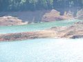
Lake Shasta from I-5
-
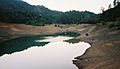
Low waters on Lake Shasta
-
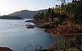
Lake from the shoreline
-
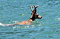
Deer swimming in Lake Shasta
-
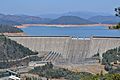
Shasta Lake and Shasta Dam


See also
 In Spanish: Lago Shasta para niños
