Shasta River facts for kids
Quick facts for kids Shasta River |
|
|---|---|

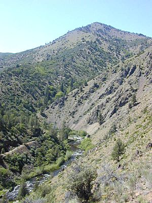
Shasta River from State Route 263
|
|
|
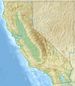
Location of the mouth of Shasta River in California
|
|
| Native name | Riviere Des Sastes |
| Other name(s) | Sastise River, Sasty River |
| Country | United States |
| State | California |
| Region | Siskiyou County |
| City | Yreka |
| Physical characteristics | |
| Main source | Mount Eddy 10 miles (16 km) south of Weed, Siskiyou County 41°24′12″N 122°26′06″W / 41.40333°N 122.43500°W |
| River mouth | Klamath River Junction of California SR's 263 and 96 2,037 ft (621 m) 41°49′51″N 122°35′39″W / 41.83083°N 122.59417°W |
| Length | 58 mi (93 km) |
| Basin features | |
| Basin size | 800 sq mi (2,100 km2) |
The Shasta River is a river in northern California, United States. It is about 58 miles (93 km) long. The river flows into the Klamath River. It helps drain the Shasta Valley. This valley is located on the west and north sides of Mount Shasta. Mount Shasta is a large volcano in the Cascade Range.
The Shasta River starts in southern Siskiyou County. This is near the Shasta-Trinity National Forest. It begins about 10 miles (16 km) southwest of Weed. The river then flows mostly northwest through the Shasta Valley. It passes through Lake Shastina. It also flows past towns like Weed and Montague. Finally, it joins the Klamath River from the south. This meeting point is about 8 miles (13 km) north-northeast of Yreka.
The Shasta Valley is a unique area. It is dominated by the huge Mount Shasta. The ground here is made of basalt rock. This rock formed from lava flows. These flows happened when Mount Shasta erupted long ago. Pluto's Cave is an example of this volcanic activity. It's a hollow space left when hot, flowing lava drained away. The valley also has many small hills. These hills are debris from a huge landslide. This landslide happened from Mount Shasta over 400,000 years ago.
Contents
The River's Journey
The Shasta River begins on the east side of Mount Eddy. This is a few miles west of Mount Shasta. It's also about 25 miles (40 km) northwest of Shasta Lake. Right away, the river flows through a wide valley. This valley is used for farming.
The Shasta River flows north, next to Interstate 5. After a few miles, it gets its first important stream. This stream is called Eddy Creek. It joins the Shasta River from the left side. This is about 37 miles (60 km) from where the Shasta River ends. The river then goes under the interstate. It winds past a ridge and flows by the town of Weed.
Next, the river turns northeast. It enters Lake Shastina. This is a lake made by a dam at its northern end. After the lake, the river turns northwest. It flows past Big Springs. This is about 30 miles (48 km) from its mouth. The river collects more water from farm fields as it goes north.
The river then flows between Yreka and Montague. This is about 10 miles (16 km) from where it joins the Klamath River. It crosses under California State Route 3 and Interstate 5 one last time. Finally, it enters a canyon in the Klamath Mountains. This is about 3 miles (5 km) from its mouth. Here, it flows next to California State Route 263. The Shasta River joins the Klamath River on its left bank. This is where State Route 263 and State Route 96 meet.
Shasta River Watershed
The Shasta River's watershed is about 800 square miles (2,100 km²) in size. A watershed is an area of land where all the water drains into a single river or lake. This watershed is a dry farming valley. It is completely located in Siskiyou County.
The Shasta River watershed is next to the Scott River on the west. It borders Butte Creek on the east. To the north, it meets the main Klamath River. The watershed is east of the Klamath Mountains. It is northwest of Mount Shasta.
Some towns in this watershed include Weed, Edgewood, Gazelle, Big Springs, Grenada, Montague, and Yreka. Important water bodies in the area are Lake Shastina (also called Dwinnell Reservoir) and Trout Lake.
The Shasta River Valley gets only about 14 inches (36 cm) of rain each year. Most of its surface water comes from underground water sources. It also gets water from snow melting on Mount Shasta. This melted snow flows out of lava tubes as springs. These springs then feed the eastern streams that flow into the Shasta River, like Big Springs Creek.
River Restoration Efforts
People are working hard to help the Shasta River. They want to protect its Chinook and Coho salmon run. A "salmon run" is when salmon swim upstream to lay their eggs. These fish are anadromous. This means they live in the ocean but return to freshwater rivers to reproduce.
The Nature Conservancy is a group that helps protect nature. They have bought two ranches in the watershed. They hope to restore the riverbanks. This will create better homes for these important fish.
Fun Activities on the River
You can go Whitewater kayaking and rafting on the Shasta River. This is usually done in the winter. The last 7 miles (11 km) of the river are best for these activities. This part is just before the Shasta River joins the Klamath River.
 | Mary Eliza Mahoney |
 | Susie King Taylor |
 | Ida Gray |
 | Eliza Ann Grier |


