
Cedar Rapids, Iowa facts for kids
Quick facts for kids
Cedar Rapids
|
|||
|---|---|---|---|
|
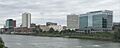
Downtown Cedar Rapids
|
|||
|
|||
| Motto(s):
The fifth season is a time to enjoy life, to enjoy the other four seasons.
|
|||

Cedar Rapids
Location in Iowa

Cedar Rapids
Location in the United States
|
|||
| Country | |||
| State | |||
| County | Linn | ||
| Incorporated | 1849 | ||
| Government | |||
| • Type | Home Rule | ||
| Area | |||
| • City | 74.26 sq mi (192.32 km2) | ||
| • Land | 73.03 sq mi (189.14 km2) | ||
| • Water | 1.23 sq mi (3.18 km2) | ||
| Elevation | 810 ft (247 m) | ||
| Population
(2020)
|
|||
| • City | 137,710 | ||
| • Rank | 204th in the United States 2nd in Iowa |
||
| • Density | 1,885.72/sq mi (728.08/km2) | ||
| • Urban | 192,844 (US: 200th) | ||
| • Urban density | 2,241.6/sq mi (865.5/km2) | ||
| • Metro | 276,520 (US: 178th) | ||
| • CSA | 455,756 | ||
| GDP | |||
| • Metro | $34.909 billion (2022) | ||
| Time zone | UTC−6 (CST) | ||
| • Summer (DST) | UTC−5 (CDT) | ||
| ZIP codes |
52227, 52228, 52233, 52324, 52338, 52401-11, 52497-99
|
||
| Area code | 319 | ||
| FIPS code | 19-12000 | ||
| GNIS feature ID | 0465941 | ||
.jpg)


Cedar Rapids is a city in Linn County, Iowa, United States. It is also the county seat, which means it's where the county government is located. In 2020, about 137,710 people lived here, making it the second-largest city in Iowa.
The city sits on both sides of the Cedar River. It is about 20 miles (32 km) north of Iowa City. Cedar Rapids is also 128 miles (206 km) northeast of Des Moines, which is Iowa's capital city.
Cedar Rapids is a major economic center for Eastern Iowa. It's located along the Interstate 380 highway. The wider Cedar Rapids area, including nearby cities like Marion and Hiawatha, had about 276,520 people in 2020. This area is also part of a larger region that includes Iowa City.
Contents
History of Cedar Rapids


How Cedar Rapids Began
Long ago, the land where Cedar Rapids is now was home to the Fox and Sac Native American tribes. The first European American settler arrived around 1837 or 1838. His name was Osgood Shepherd, and he built a log cabin by the Cedar River.
The true founders of the city were George Greene and Nicholas Brown. They saw that the rapids in the river were a great spot to build mills. Mills use the power of flowing water to grind grain. In 1841, they bought Shepherd's land and named their new town Rapids City. Brown built the first mill, and later, a proper dam was built to power many mills.
At first, the city was only on the east side of the river. A village called Kingston grew on the west side. On January 15, 1849, the town was officially named Cedar Rapids. It was named after the rapids and the many red cedar trees along the river. At that time, fewer than 400 people lived there.
Growing the City
In the 1850s, Cedar Rapids grew. Many Czech immigrants moved to the city. By 1856, about a quarter of the 1,600 residents were Czech. Coe College was founded in 1851. Leaders also worked to connect the city to other places. The first train arrived in 1859, which was very important for the city's growth.
In 1870, Cedar Rapids joined with the community of Kingston. They built a bridge across the river to connect the two sides. The city's economy grew even more when the Sinclair meatpacking company started in 1871. It became one of the biggest meat factories in the country. In 1873, a large oatmeal mill was built. This mill later became part of the Quaker Oats Company, and it's now the biggest cereal mill in the world.
In 1909, the city bought May's Island in the middle of the river. They wanted to build the city government buildings there. This was hoped to help ease tensions between people living on the east and west sides of the river. In 1919, the county government also moved its main offices to Cedar Rapids, building a new courthouse on the island.
Major Floods in Cedar Rapids
Cedar Rapids has faced big floods from the Cedar River.
The 2008 Flood

In June 2008, the Cedar River rose to a record high level. It flooded over 1,100 city blocks, which is more than 10 square miles (26 km²). This affected 14% of the city. About 7,749 buildings had to be evacuated, including homes and city offices like City Hall and the main library. Many buildings had to be torn down because of the damage. The flood caused billions of dollars in damage. Over 4,000 members of the Iowa National Guard helped the city.
The 2016 Flood
In September 2016, the Cedar River flooded again. This time, it was caused by heavy rains from a storm that was once Hurricane Paine. The river reached its second-highest level ever. Over 5,000 homes were affected, and more than 5,000 people had to leave their homes. Schools in Cedar Rapids were closed for a week.
The city had started a plan in 2015 to build better flood protection. Even though the plan wasn't finished, many volunteers and National Guard troops worked hard. They filled over 250,000 sandbags and built temporary barriers. This helped prevent worse flooding in many parts of the city. A curfew was put in place at night to keep people safe.
The 2020 Derecho Storm
On August 10, 2020, a very strong storm called a derecho hit Cedar Rapids. A derecho is like a widespread, long-lived wind storm. Winds reached up to 140 miles per hour (225 km/h) in some areas. This storm damaged most homes and businesses in the city. Thousands of trees were knocked down, blocking roads. About 95% of the city lost power.
Hospitals treated over 300 people for storm-related injuries. Officials said the damage was even worse than the 2008 flood. Cleaning up all the downed trees and debris took many months.
Geography of Cedar Rapids

Cedar Rapids is divided into four sections, called quadrants. These are used for street addresses. 1st Avenue divides the north and south parts of the city. The Cedar River divides the east and west parts. Mays Island, which is in the middle of the river, is the only place where addresses don't use a quadrant.
The city covers about 72 square miles (186 km²). Most of this is land, with a small amount of water.
Neighborhoods in Cedar Rapids
Cedar Rapids has many neighborhoods. Some of the older ones near downtown include Wellington Heights and Oakhill Jackson. Farther north, you'll find Noelridge Park and Kenwood Park.
There are also many unofficial neighborhoods like Bowman Woods and Vernon Heights.
Czech Village

The Czech Village is a special area along 16th Avenue SW. It celebrates the city's Czech heritage. You can find Czech-themed shops and bakeries there. The National Czech & Slovak Museum & Library is a major attraction. After the 2008 flood, the museum moved to a new location. In 2024, a new astronomical clock was built in the village. The presidents of the Czech Republic and Slovakia even attended its opening!
Climate in Cedar Rapids
Cedar Rapids has a climate with four distinct seasons. Winters are long, cold, and snowy. Summers are hot and humid, often with strong thunderstorms.
The coldest temperature ever recorded in Cedar Rapids was −30°F (−34°C) on January 31, 2019. The hottest temperature ever was 110°F (43°C) on July 6, 1911.
| Climate data for Cedar Rapids, Iowa (The Eastern Iowa Airport), 1991–2020 normals, extremes 1893–present | |||||||||||||
|---|---|---|---|---|---|---|---|---|---|---|---|---|---|
| Month | Jan | Feb | Mar | Apr | May | Jun | Jul | Aug | Sep | Oct | Nov | Dec | Year |
| Record high °F (°C) | 65 (18) |
76 (24) |
88 (31) |
95 (35) |
104 (40) |
103 (39) |
110 (43) |
108 (42) |
105 (41) |
94 (34) |
79 (26) |
73 (23) |
110 (43) |
| Mean daily maximum °F (°C) | 27.9 (−2.3) |
32.6 (0.3) |
46.3 (7.9) |
60.1 (15.6) |
71.1 (21.7) |
80.1 (26.7) |
82.8 (28.2) |
81.2 (27.3) |
74.7 (23.7) |
61.5 (16.4) |
46.2 (7.9) |
33.3 (0.7) |
58.2 (14.5) |
| Daily mean °F (°C) | 19.6 (−6.9) |
24.1 (−4.4) |
36.5 (2.5) |
48.9 (9.4) |
60.3 (15.7) |
69.9 (21.1) |
72.8 (22.7) |
70.8 (21.6) |
63.3 (17.4) |
50.7 (10.4) |
37.0 (2.8) |
25.2 (−3.8) |
48.3 (9.0) |
| Mean daily minimum °F (°C) | 11.3 (−11.5) |
15.5 (−9.2) |
26.8 (−2.9) |
37.6 (3.1) |
49.5 (9.7) |
59.7 (15.4) |
62.7 (17.1) |
60.4 (15.8) |
51.9 (11.1) |
39.9 (4.4) |
27.7 (−2.4) |
17.1 (−8.3) |
38.3 (3.5) |
| Record low °F (°C) | −30 (−34) |
−27 (−33) |
−20 (−29) |
1 (−17) |
24 (−4) |
36 (2) |
42 (6) |
37 (3) |
22 (−6) |
−2 (−19) |
−11 (−24) |
−28 (−33) |
−30 (−34) |
| Average precipitation inches (mm) | 0.95 (24) |
1.22 (31) |
1.99 (51) |
3.56 (90) |
4.25 (108) |
5.56 (141) |
4.41 (112) |
4.07 (103) |
3.40 (86) |
2.91 (74) |
2.00 (51) |
1.59 (40) |
35.91 (911) |
| Average snowfall inches (cm) | 6.2 (16) |
6.9 (18) |
3.1 (7.9) |
1.0 (2.5) |
0.0 (0.0) |
0.0 (0.0) |
0.0 (0.0) |
0.0 (0.0) |
0.0 (0.0) |
0.0 (0.0) |
1.7 (4.3) |
7.8 (20) |
26.7 (68.7) |
| Average precipitation days (≥ 0.01 inch) | 7.2 | 6.7 | 9.1 | 11.9 | 12.5 | 12.3 | 9.8 | 9.9 | 8.6 | 9.2 | 8.1 | 8.0 | 113.3 |
| Average snowy days (≥ 0.1 in) | 4.6 | 4.2 | 2.4 | 0.5 | 0.0 | 0.0 | 0.0 | 0.0 | 0.0 | 0.0 | 1.0 | 4.6 | 17.3 |
| Source 1: NOAA (snow/snow days 1981–2010) | |||||||||||||
| Source 2: National Weather Service | |||||||||||||
People of Cedar Rapids
| Historical populations | ||
|---|---|---|
| Year | Pop. | ±% |
| 1860 | 1,830 | — |
| 1870 | 5,940 | +224.6% |
| 1880 | 10,104 | +70.1% |
| 1890 | 18,020 | +78.3% |
| 1900 | 25,656 | +42.4% |
| 1910 | 32,811 | +27.9% |
| 1920 | 45,566 | +38.9% |
| 1930 | 56,097 | +23.1% |
| 1940 | 62,120 | +10.7% |
| 1950 | 72,296 | +16.4% |
| 1960 | 92,035 | +27.3% |
| 1970 | 110,642 | +20.2% |
| 1980 | 110,243 | −0.4% |
| 1990 | 108,772 | −1.3% |
| 2000 | 120,758 | +11.0% |
| 2010 | 126,326 | +4.6% |
| 2020 | 137,710 | +9.0% |
| 2021(est) | 136,467 | −0.9% |
| and Iowa Data Center Source: |
||


The Cedar Rapids metropolitan area includes Linn, Benton, and Jones counties. In 2020, about 276,520 people lived in this larger area. Many people who work in Cedar Rapids live in nearby towns like Marion and Hiawatha.
Population in 2020
In 2020, Cedar Rapids had 137,710 people. The city had about 62,398 homes. Most people (77.8%) were White. About 10.4% were Black or African American, and 2.7% were Asian. People of Hispanic or Latino background made up 4.7% of the population.
| Race / Ethnicity (NH = Non-Hispanic) | Pop 2000 | Pop 2010 | Pop 2020 | % 2000 | % 2010 | % 2020 |
|---|---|---|---|---|---|---|
| White alone (NH) | 109,759 | 108,696 | 105,250 | 90.89% | 86.04% | 76.43% |
| Black or African American alone (NH) | 4,425 | 6,880 | 14,153 | 3.66% | 5.45% | 10.28% |
| Native American or Alaska Native alone (NH) | 279 | 338 | 274 | 0.23% | 0.27% | 0.20% |
| Asian alone (NH) | 2,121 | 2,779 | 3,747 | 1.76% | 2.20% | 2.72% |
| Pacific Islander alone (NH) | 77 | 132 | 484 | 0.06% | 0.10% | 0.35% |
| Other race alone (NH) | 145 | 107 | 404 | 0.12% | 0.08% | 0.29% |
| Mixed race or Multiracial (NH) | 1,887 | 3,218 | 6,896 | 1.56% | 2.55% | 5.01% |
| Hispanic or Latino (any race) | 2,065 | 4,176 | 6,502 | 1.71% | 3.31% | 4.72% |
| Total | 120,758 | 126,326 | 137,710 | 100.00% | 100.00% | 100.00% |
Religion in Cedar Rapids
The Mother Mosque of America in Cedar Rapids opened on June 16, 1934. It is the oldest mosque still standing in North America. Muslim immigrants from Lebanon and Syria first arrived in the area in 1895. The mosque was damaged in the 2008 flood but has been repaired.
Economy of Cedar Rapids

Cedar Rapids is a major center for processing corn. The grain processing industry is very important here. It provides thousands of jobs. Many large companies have offices or factories in Cedar Rapids. These include Collins Aerospace, CRST (a trucking company), and Aegon (which has its U.S. headquarters here).
The large Quaker Oats Company mill, which is the biggest cereal mill in the world, is a famous landmark. Other big companies like Archer Daniels Midland, Cargill, and General Mills also have facilities in the city.
Top Employers in Cedar Rapids
Here are some of the largest employers in Cedar Rapids:
| # | Employer | Employees |
|---|---|---|
| 1 | Collins Aerospace | 9,400 |
| 2 | Transamerica | 3,800 |
| 3 | St. Luke's Hospital | 2,979 |
| 4 | Cedar Rapids Community School District | 2,879 |
| 5 | Hy-Vee | 2,356 |
| 6 | Nordstrom Direct | 2,150 |
| 7 | Mercy Medical Center | 2,140 |
| 8 | City of Cedar Rapids | 1,309 |
| 9 | Four Oaks | 1,100 |
| 10 | Quaker Oats Company | 920 |
Tourism in Cedar Rapids
Cedar Rapids is known as the "City of Five Seasons." This nickname means there's a "fifth season" to enjoy the other four seasons. The symbol for this is the Tree of Five Seasons sculpture downtown.
The city has many places to visit. These include the Cedar Rapids Museum of Art, the National Czech & Slovak Museum & Library, and the African American Museum of Iowa. The Paramount Theatre and Orchestra Iowa offer live performances. Several famous actors, like Ashton Kutcher and Elijah Wood, grew up in Cedar Rapids.
Arts and Culture in Cedar Rapids


Cedar Rapids has a lively arts and culture scene. It is home to Orchestra Iowa, the Paramount Theatre, and Theatre Cedar Rapids. You can also visit Brucemore, which is a historic site.
The Cedar Rapids Museum of Art has the largest collection of paintings by the famous artist Grant Wood. His studio, 5 Turner Alley, is also in Cedar Rapids. Many of these art centers were damaged in the 2008 flood but have since reopened.
The City Flag
The current flag of Cedar Rapids was chosen on September 8, 2021. The blue on the flag stands for the Cedar River. The green represents the city's green spaces. An arch shape on the flag shows progress and the city's flood wall. The five stars on the flag represent the "City of Five Seasons" nickname and the historic buildings on Mays Island.
Before this, Cedar Rapids had a different flag that was often criticized. Because of this, the city decided to create a new design with input from its residents.
Sports in Cedar Rapids
Cedar Rapids is home to several sports teams.
- The Cedar Rapids Kernels are a minor league baseball team. They play at Veterans Memorial Stadium. They are connected to the Minnesota Twins major league team.
- The Cedar Rapids RoughRiders are a junior ice hockey team. They play at the Cedar Rapids Ice Arena.
- The Iowa Raptors FC is a soccer team that started playing in 2021.
Kingston Stadium is a large stadium in Cedar Rapids used for American football and soccer. The city also hosts the Fifth Season Races, which include an 8-kilometer and a 5-kilometer run.
Parks and Recreation in Cedar Rapids

Cedar Rapids has over 3,360 acres (13.6 km²) of parks and green spaces. There are 74 named parks and recreation spots. These include fields for baseball and softball, basketball courts, and frisbee golf courses. You can also find the Tuma Soccer Complex, a BMX dirt track, and dog parks.
Old MacDonald's Farm is a children's zoo. The city also has 10 splash pads for cooling off in the summer. There are 24 miles (39 km) of trails for walking, running, or biking. The YMCA has been in Cedar Rapids since 1868 and offers many programs.
Education in Cedar Rapids

Colleges and Universities
Cedar Rapids has two four-year colleges: Coe College and Mount Mercy University. The University of Iowa also has an evening business program here. Kirkwood Community College is the local two-year college. Other universities like Kaplan University and Upper Iowa University also have campuses in the city.
Schools for Kids
The Cedar Rapids Community School District is the largest school district in the area. It has 24 elementary schools, six middle schools, and four high schools. These high schools are Jefferson, Washington, Kennedy, and Metro High School.
Some parts of Cedar Rapids are also served by the Linn-Mar Community School District and the College Community School District. The College Community School District has a central campus with several schools, including Prairie High School.
There are also several private schools in Cedar Rapids. These include Catholic schools like Xavier, and other private schools like Summit Schools and Cedar Valley Christian School.
Media in Cedar Rapids
Radio Stations
Cedar Rapids has many radio stations. Some popular ones include WMT 600 AM for news and talk, KKSY-FM 96.5 for country music, and KKRQ 100.7 FM for classic rock. KDAT 104.5 FM plays adult contemporary music, and KZIA 102.9 FM plays contemporary hits. KCCK-FM 88.3 FM is a non-commercial jazz station run by Kirkwood Community College.
Television Stations
Cedar Rapids is part of a larger TV market that includes Waterloo, Iowa City, and Dubuque. Local TV stations include KGAN channel 2 (CBS), KCRG-TV channel 9 (ABC), and KPXR-TV channel 48 (Ion). NBC affiliate KWWL channel 7 is based in Waterloo but has a newsroom in Cedar Rapids.
Newspapers
The Gazette is the main daily newspaper for Cedar Rapids. It won a special award called a Pulitzer Prize in 1936 for its work against corruption in Iowa.
Movies Filmed in or About Cedar Rapids
The 2011 comedy film Cedar Rapids is set in the city. However, most of the movie was actually filmed in Michigan, though some outdoor shots were done in Cedar Rapids.
The 2017 science fiction movie Amelia 2.0 was mostly filmed in Cedar Rapids. It used famous places like the Cedar Rapids Public Library. The 2010 horror film The Crazies is set near Cedar Rapids. Also, the 2007 film The Final Season about a high school baseball team includes scenes filmed in Cedar Rapids.
Infrastructure and Transportation

Cedar Rapids has a public transportation system called Cedar Rapids Transit. It includes an extensive bus system and taxi services. The buses travel throughout the city and to nearby Marion and Hiawatha. There's also a special bus service, the 380 Express, that connects Cedar Rapids to Coralville and Iowa City.
Downtown, several buildings are connected by enclosed walkways called skywalks.
The city is served by The Eastern Iowa Airport, which connects to other regional and international airports.
Major highways like I-380 run through Cedar Rapids. Other U.S. Highways and Iowa Highways also serve the city.
Cedar Rapids is also a hub for four major railroads. These include the Union Pacific and the Cedar Rapids and Iowa City Railway (Crandic). The city was once a major stop for passenger trains, but this service ended in the 1970s. You can still travel to other Midwestern cities by bus through the Burlington Trailways hub at the airport.
Images for kids
-
Downtown Cedar Rapids
-

Seal of Cedar Rapids
-

Flag of Cedar Rapids
See also
 In Spanish: Cedar Rapids (Iowa) para niños
