Cedar County, Iowa facts for kids
Quick facts for kids
Cedar County
|
|
|---|---|

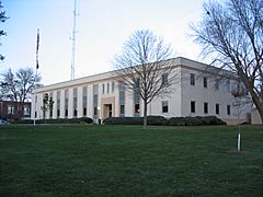
Cedar County Courthouse
|
|

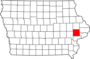
Location within the U.S. state of Iowa
|
|
 Iowa's location within the U.S. |
|
| Country | |
| State | |
| Founded | 1837 |
| Named for | Cedar River |
| Seat | Tipton |
| Largest city | Tipton |
| Area | |
| • Total | 582 sq mi (1,510 km2) |
| • Land | 579 sq mi (1,500 km2) |
| • Water | 2.5 sq mi (6 km2) 0.4% |
| Population
(2020)
|
|
| • Total | 18,505 |
| • Density | 32/sq mi (12/km2) |
| Time zone | UTC−6 (Central) |
| • Summer (DST) | UTC−5 (CDT) |
| Congressional district | 2nd |
Cedar County is a county in the state of Iowa, USA. A county is like a smaller region within a state. In 2020, about 18,505 people lived here. The main town, or county seat, is Tipton. The county gets its name from the Cedar River, which flows through it.
Cedar County is special because it's located between three big city areas: Cedar Rapids, the Quad Cities, and Iowa City. People sometimes call this the "Tri-Metro" area. It's also the only county in Iowa named after a tree!
Contents
History of Cedar County
Cedar County was officially created on December 21, 1837. It was formed from parts of another area called Dubuque County. As you know, it was named after the Cedar River.
In 1840, the town of Tipton was started. Tipton is still the county seat today.
Before the Civil War, the area around West Branch was very important. It was a key part of the Underground Railroad. This was a secret network that helped enslaved people from the southern states find freedom.
A famous person, Herbert Hoover, was born in West Branch in Cedar County in 1874. He later became the 31st President of the United States.
The Cedar County Sheriff's House and Jail is an interesting old building. It was used as both a jail and the sheriff's home for a very long time. It closed in 2001 and was added to the National Register of Historic Places in 2003.
Geography and Nature
Cedar County covers a total area of about 582 square miles (1,507 square kilometers). Most of this is land, about 579 square miles (1,499 square kilometers). Only a small part, about 2.5 square miles (6.5 square kilometers), is water. Rock Creek is one of the waterways that flows through Cedar County.
Main Roads
Several important highways pass through Cedar County, making it easy to travel.
 Interstate 80
 U.S. Highway 6
 U.S. Highway 30
 Iowa Highway 38
 Iowa Highway 130
Neighboring Counties
Cedar County shares its borders with several other counties:
- Jones County to the north
- Clinton County to the northeast
- Scott County to the southeast
- Muscatine County to the south
- Johnson County to the west
- Linn County to the northwest
Special Protected Area
- Herbert Hoover National Historic Site is a place that protects the birthplace and early home of President Herbert Hoover.
People and Population
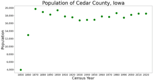
The number of people living in Cedar County has changed over the years. Here's how the population has grown or shrunk according to the U.S. Census:
| Historical population | |||
|---|---|---|---|
| Census | Pop. | %± | |
| 1850 | 3,941 | — | |
| 1860 | 12,949 | 228.6% | |
| 1870 | 19,731 | 52.4% | |
| 1880 | 18,936 | −4.0% | |
| 1890 | 18,253 | −3.6% | |
| 1900 | 19,371 | 6.1% | |
| 1910 | 17,765 | −8.3% | |
| 1920 | 17,560 | −1.2% | |
| 1930 | 16,760 | −4.6% | |
| 1940 | 16,884 | 0.7% | |
| 1950 | 16,910 | 0.2% | |
| 1960 | 17,791 | 5.2% | |
| 1970 | 17,655 | −0.8% | |
| 1980 | 18,635 | 5.6% | |
| 1990 | 17,444 | −6.4% | |
| 2000 | 18,187 | 4.3% | |
| 2010 | 18,499 | 1.7% | |
| 2020 | 18,505 | 0.0% | |
| 2023 (est.) | 18,302 | −1.1% | |
| U.S. Decennial Census 1790-1960 1900-1990 1990-2000 2010-2018 |
|||
What the 2020 Census Shows
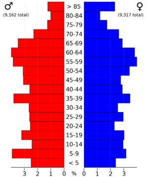
In 2020, the census counted 18,505 people in Cedar County. This means there were about 32 people living in each square mile. Most people (about 91.92%) were non-Hispanic White. Other groups included Black, Hispanic, Native American, and Asian people. About 4.51% of the population identified as more than one race.

Towns and Communities
Cedar County has several towns and smaller communities.
Cities
Special Community (CDP)
- Rochester is a "Census-designated place" (CDP). This means it's a community that looks like a town but isn't officially governed as a city.
Smaller Communities (Unincorporated)
- Buchanan
- Cedar Bluff
- Cedar Valley
- Centerdale
- Downey
- Lime City
- Plato
- Massillon
- Springdale
- Sunbury
- Wald
Townships
Cedar County is also divided into seventeen smaller areas called townships:
- Cass
- Center
- Dayton
- Fairfield
- Farmington
- Fremont
- Gower
- Inland
- Iowa
- Linn
- Massillon
- Pioneer
- Red Oak
- Rochester
- Springdale
- Springfield
- Sugar Creek
Biggest Towns by Population
Here are the towns in Cedar County ranked by how many people live in them, based on the 2020 census. The † symbol means it's the county seat.
| Rank | City/Town/etc. | Type | Population (2020 Census) |
|---|---|---|---|
| 1 | † Tipton | City | 3,149 |
| 2 | Wilton (mostly in Muscatine County) | City | 2,924 |
| 3 | West Branch (partially in Johnson County) | City | 2,509 |
| 4 | Durant (partially in Muscatine and Scott Counties) | City | 1,871 |
| 5 | Clarence | City | 1,039 |
| 6 | Mechanicsville | City | 1,020 |
| 7 | Lowden | City | 807 |
| 8 | Stanwood | City | 637 |
| 9 | Bennett | City | 347 |
| 10 | Rochester | CDP | 142 |
Famous People from Cedar County
- Herbert Hoover (1874–1964): He was the 31st President of the United States from 1929 to 1933. He was born in West Branch in 1874 and was the first president born west of the Mississippi River.
- John Brown (1800–1859): He was an abolitionist, meaning he worked to end slavery. He stayed near the community of Springdale in Cedar County while planning his actions to help free enslaved people. Two local men, Edwin and Barclay Coppock, also helped him.
- Lawrie Tatum (1822–1900): He was an agent who worked with the Kiowa and Comanche Native American tribes. Later, starting in 1884, he became the guardian for the future President Herbert Hoover.
See also
 In Spanish: Condado de Cedar (Iowa) para niños
 | Toni Morrison |
 | Barack Obama |
 | Martin Luther King Jr. |
 | Ralph Bunche |


