Clinton County, Iowa facts for kids
Quick facts for kids
Clinton County
|
|
|---|---|

|
|

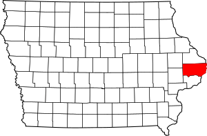
Location within the U.S. state of Iowa
|
|
 Iowa's location within the U.S. |
|
| Country | |
| State | |
| Founded | 1837 |
| Named for | DeWitt Clinton |
| Seat | Clinton |
| Largest city | Clinton |
| Area | |
| • Total | 710 sq mi (1,800 km2) |
| • Land | 695 sq mi (1,800 km2) |
| • Water | 15 sq mi (40 km2) 2.1% |
| Population
(2020)
|
|
| • Total | 46,460 |
| • Estimate
(2023)
|
46,158 |
| • Density | 65.4/sq mi (25.27/km2) |
| Time zone | UTC−6 (Central) |
| • Summer (DST) | UTC−5 (CDT) |
| Congressional district | 2nd |
Clinton County is a special area of land, known as a county, in the state of Iowa. It's like a big neighborhood with its own local government. In 2020, about 46,460 people lived here. The main city and where the county government is located is Clinton. The county was named after DeWitt Clinton, who was a famous governor of New York.
Contents
History of Clinton County
Clinton County was officially created on December 21, 1837. It was named after DeWitt Clinton, a former Governor of New York. He was a big supporter of building the Erie Canal, which was a very important waterway. The cities of DeWitt and Clinton in the county are also named after him.
Early Settlers and Growth
The first person to settle in this area was Elijah Buell in 1835. He built a log cabin for his family. In 1854, the county got its first newspaper, which helped people stay informed. A special school for girls, the Lyons Female College, opened in 1858. It cost about $175 per student to attend.
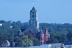
The county has had three different courthouses over the years. The one used today was built in 1897. It has a unique Romanesque style, which is a type of architecture.
The first official settlement in Clinton County happened in 1836. The county's population grew quite a bit in its early years. In 1840, there were 821 people. By 1856, the population had grown to 11,000!
Geography and Location
Clinton County covers a total area of about 710 square miles. Most of this (695 square miles) is land, and about 15 square miles is water. The county is home to the easternmost point in Iowa, which is located on the Mississippi River.
Getting Around Clinton County
- Clinton Municipal Transit Administration (This is the local bus system.)
Main Roads
 US 30
US 30 US 61
US 61 US 67
US 67 Iowa 136
Neighboring Counties
Clinton County shares its borders with several other counties:
- Jackson County (to the north)
- Carroll County, Illinois (to the northeast)
- Whiteside County, Illinois (to the east)
- Rock Island County, Illinois (to the southeast)
- Scott County (to the south)
- Cedar County (to the southwest)
- Jones County (to the northwest)
Protected Natural Areas
- Upper Mississippi River National Wildlife and Fish Refuge (part of this important wildlife area is in Clinton County)
Population and People
| Historical population | |||
|---|---|---|---|
| Census | Pop. | %± | |
| 1840 | 821 | — | |
| 1850 | 2,822 | 243.7% | |
| 1860 | 18,938 | 571.1% | |
| 1870 | 35,357 | 86.7% | |
| 1880 | 36,763 | 4.0% | |
| 1890 | 41,199 | 12.1% | |
| 1900 | 43,832 | 6.4% | |
| 1910 | 45,394 | 3.6% | |
| 1920 | 43,371 | −4.5% | |
| 1930 | 44,377 | 2.3% | |
| 1940 | 44,722 | 0.8% | |
| 1950 | 49,664 | 11.1% | |
| 1960 | 55,060 | 10.9% | |
| 1970 | 56,749 | 3.1% | |
| 1980 | 57,122 | 0.7% | |
| 1990 | 51,040 | −10.6% | |
| 2000 | 50,149 | −1.7% | |
| 2010 | 49,116 | −2.1% | |
| 2020 | 46,460 | −5.4% | |
| 2023 (est.) | 46,158 | −6.0% | |
| U.S. Decennial Census 1790-1960 1900-1990 1990-2000 2010-2018 |
|||
What the 2020 Census Shows

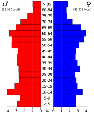
The 2020 census counted 46,460 people living in Clinton County. This means there were about 67 people for every square mile of land. Most people (94.95%) said they belonged to one race. There were 21,517 homes, and 19,483 of them were lived in.
| Race | Number | Percentage |
|---|---|---|
| White | 41,226 | 88.73% |
| Black or African American | 1,392 | 3% |
| Native American | 103 | 0.22% |
| Asian | 252 | 0.54% |
| Pacific Islander | 10 | 0.02% |
| Other/Mixed | 1,938 | 4.2% |
| Hispanic or Latino | 1,539 | 3.31% |
What the 2010 Census Showed
In 2010, the county had 49,116 people. There were 21,733 homes, and 20,223 of them were occupied.
Towns and Areas
Cities in Clinton County
Smaller Communities (Unincorporated)
These are smaller places that are not officially cities or towns:
- Big Rock (mostly in Scott County)
- Bryant
- Buena Vista
- Elvira
- Elwood
- Folletts
- Petersville
- Teeds Grove
Townships
Clinton County is also divided into these smaller areas called townships:
- Bloomfield
- Brookfield
- Camanche
- Center
- De Witt
- Deep Creek
- Eden
- Elk River
- Grant
- Hampshire
- Liberty
- Olive
- Orange
- Sharon
- Spring Rock
- Washington
- Waterford
- Welton
City Populations (2020)
Here's a list of the cities and towns in Clinton County, ranked by how many people lived there in 2020: † county seat
| Rank | City/Town/etc. | Type | Population (2020 Census) |
|---|---|---|---|
| 1 | Clinton † | City | 24,469 |
| 2 | DeWitt | City | 5,514 |
| 3 | Camanche | City | 4,570 |
| 4 | Wheatland | City | 775 |
| 5 | Grand Mound | City | 615 |
| 6 | Delmar | City | 542 |
| 7 | Lost Nation | City | 434 |
| 8 | Charlotte | City | 389 |
| 9 | Calamus | City | 356 |
| 10 | Low Moor | City | 250 |
| 11 | Goose Lake | City | 239 |
| 12 | Welton | City | 121 |
| 13 | Andover | City | 109 |
| 14 | Toronto | City | 102 |
See also
 In Spanish: Condado de Clinton (Iowa) para niños
 | Sharif Bey |
 | Hale Woodruff |
 | Richmond Barthé |
 | Purvis Young |


