
Carroll County, Illinois facts for kids
Quick facts for kids
Carroll County
|
|
|---|---|

Carroll County Courthouse
|
|

Location within the U.S. state of Illinois
|
|
 Illinois's location within the U.S. |
|
| Country | |
| State | |
| Founded | 1839 |
| Named for | Charles Carroll |
| Seat | Mount Carroll |
| Largest city | Savanna |
| Area | |
| • Total | 466 sq mi (1,210 km2) |
| • Land | 445 sq mi (1,150 km2) |
| • Water | 22 sq mi (60 km2) 4.6% |
| Population
(2020)
|
|
| • Total | 15,702 |
| • Estimate
(2023)
|
15,526 |
| • Density | 33.70/sq mi (13.010/km2) |
| Time zone | UTC−6 (Central) |
| • Summer (DST) | UTC−5 (CDT) |
| Congressional district | 17th |
Carroll County is a county located in the state of Illinois, in the United States. It's a place where about 15,702 people lived in 2020. The main town, or county seat, where the county government is located, is Mount Carroll.
Contents
History of Carroll County
Carroll County was created in 1839. It was formed from a part of Jo Daviess County. The county got its name from Charles Carroll of Carrollton. He was a very important person who signed the Declaration of Independence. Charles Carroll was the last person who signed this famous document to pass away, in 1832.
-
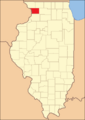
Carroll County looked like this when it was first created in 1839.

Geography and Nature
Carroll County covers a total area of about 466 square miles. Most of this area, 445 square miles, is land. The remaining 22 square miles (about 4.6%) is water.
You can find some cool natural spots here! The Mississippi Palisades State Park is in Carroll County, just north of the city of Savanna. Part of the Savanna Army Depot is also located in this county.
Neighboring Counties
Carroll County shares its borders with several other counties:
- Stephenson County to the northeast
- Ogle County to the east
- Whiteside County to the south
- Clinton County, Iowa to the southwest
- Jackson County, Iowa to the west
- Jo Daviess County to the northwest
Protected Natural Areas
A part of the Upper Mississippi River National Wildlife and Fish Refuge is located in Carroll County. This refuge helps protect wildlife and fish along the Mississippi River.
Main Roads
Several important highways run through Carroll County, making it easy to travel around:
 US Route 52
 Illinois Route 40
 Illinois Route 64
 Illinois Route 72
 Illinois Route 73
 Illinois Route 78
 Illinois Route 84
Climate and Weather
| Weather chart for Mount Carroll, Illinois | |||||||||||||||||||||||||||||||||||||||||||||||
|---|---|---|---|---|---|---|---|---|---|---|---|---|---|---|---|---|---|---|---|---|---|---|---|---|---|---|---|---|---|---|---|---|---|---|---|---|---|---|---|---|---|---|---|---|---|---|---|
| J | F | M | A | M | J | J | A | S | O | N | D | ||||||||||||||||||||||||||||||||||||
|
1.4
29
7
|
1.5
35
13
|
2.6
47
25
|
3.7
60
35
|
4.3
72
46
|
4.8
82
54
|
3.8
85
59
|
4.5
83
56
|
3.5
76
47
|
2.7
64
36
|
2.8
47
26
|
2
34
14
|
||||||||||||||||||||||||||||||||||||
| temperatures in °F precipitation totals in inches source: The Weather Channel |
|||||||||||||||||||||||||||||||||||||||||||||||
|
Metric conversion
|
|||||||||||||||||||||||||||||||||||||||||||||||
The weather in Mount Carroll, the county seat, changes a lot throughout the year. In January, the average low temperature is about 7°F (about -14°C). In July, the average high temperature reaches about 85°F (about 29°C).
The coldest temperature ever recorded was -31°F (-35°C) in January 1910. The hottest was 108°F (42°C) in July 1936. The amount of rain and snow also varies. June usually gets the most precipitation, with about 4.77 inches. January gets the least, with about 1.43 inches.
People and Population
| Historical population | |||
|---|---|---|---|
| Census | Pop. | %± | |
| 1840 | 1,023 | — | |
| 1850 | 4,586 | 348.3% | |
| 1860 | 11,733 | 155.8% | |
| 1870 | 16,705 | 42.4% | |
| 1880 | 16,976 | 1.6% | |
| 1890 | 18,320 | 7.9% | |
| 1900 | 18,963 | 3.5% | |
| 1910 | 18,035 | −4.9% | |
| 1920 | 19,345 | 7.3% | |
| 1930 | 18,433 | −4.7% | |
| 1940 | 17,987 | −2.4% | |
| 1950 | 18,976 | 5.5% | |
| 1960 | 19,507 | 2.8% | |
| 1970 | 19,276 | −1.2% | |
| 1980 | 18,779 | −2.6% | |
| 1990 | 16,805 | −10.5% | |
| 2000 | 16,674 | −0.8% | |
| 2010 | 15,387 | −7.7% | |
| 2020 | 15,702 | 2.0% | |
| 2023 (est.) | 15,526 | 0.9% | |
| U.S. Decennial Census 1790-1960 1900-1990 1990-2000 2010 |
|||
In 2010, there were 15,387 people living in Carroll County. There were 6,622 households and 4,343 families. A household is a group of people living together in one home. A family is a group of related people living together.
Most people in the county, about 96.9%, were white. About 2.8% of the population were of Hispanic or Latino background. Many people had German (40.4%), Irish (14.0%), or English (11.2%) ancestry.
The average age of people in the county was 46.5 years old. About 26.3% of households had children under 18 living with them.
The median income for a household was $44,805. This means half of the households earned more than this, and half earned less. For families, the median income was $55,341. About 11.7% of all people in the county lived below the poverty line. This means their income was below a certain level set by the government.
Education
Carroll County has several school districts that help students learn and grow:
- Chadwick-Milledgeville Community Unit School District 399
- Eastland Community Unit School District 308
- West Carroll Community Unit School District 314
Communities in Carroll County
Carroll County has several cities and villages, each with its own population and area. The table below shows some of these communities.
| Community |
Community type |
Population | Total Area |
Water Area |
Land Area |
Pop. Density |
|
|---|---|---|---|---|---|---|---|
| Chadwick | village | 481 | 0.31 | 0.00 | 0.31 | 1,546.62 | |
| Lanark | city | 1,504 | 1.12 | 0.00 | 1.12 | 1,341.66 | |
| Milledgeville | village | 1,026 | 0.69 | 0.00 | 0.69 | 1,486.96 | |
| Mount Carroll (seat) | city | 1,479 | 2.00 | 0.00 | 2.00 | 738.39 | |
| Savanna | city | 2,783 | 2.71 | 0.09 | 2.62 | 1,063.84 | |
| Shannon | village | 801 | 0.48 | 0.00 | 0.48 | 1,661.83 | |
| Thomson | village | 1,610 | 2.22 | 0.00 | 2.22 | 725.55 | |
| Carroll County | county | 15,702 | 466 | 22 | 445 | 34 |
Townships
Carroll County is also divided into smaller areas called townships. These are local government areas. There are twelve townships in Carroll County:
- Cherry Grove-Shannon
- Elkhorn Grove
- Fairhaven
- Freedom
- Mount Carroll
- Rock Creek-Lima
- Salem
- Savanna
- Washington
- Woodland
- Wysox
- York
Other Places
- Lake Carroll is a "census designated place." This means it's a community that is counted in the census but isn't officially a city or village.
There are also many smaller, "unincorporated communities" in Carroll County. These are places where people live, but they don't have their own local government like a city or village. Some of these include:
Notable People from Carroll County
Some interesting people have connections to Carroll County:
- John Acker: An Illinois state representative who was born near Savanna.
- Willis J. Bailey: A U.S. Representative from Kansas and the 16th Governor of Kansas.
- Neva Burright: An Illinois harness racing driver. She was the first woman to win a Grand Circuit race.
- David J. Summerville: A Wisconsin State Assemblyman.
Images for kids
-
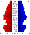
This chart shows the age groups of people in Carroll County from the 2000 census.

See also
 In Spanish: Condado de Carroll (Illinois) para niños
