
Ogle County, Illinois facts for kids
Quick facts for kids
Ogle County
|
|
|---|---|

|
|

Location within the U.S. state of Illinois
|
|
 Illinois's location within the U.S. |
|
| Country | |
| State | |
| Founded | January 16, 1836 |
| Named for | Joseph Ogle |
| Seat | Oregon |
| Largest city | Rochelle |
| Area | |
| • Total | 763 sq mi (1,980 km2) |
| • Land | 759 sq mi (1,970 km2) |
| • Water | 4.4 sq mi (11 km2) 0.6% |
| Population
(2020)
|
|
| • Total | 51,788 |
| • Estimate
(2023)
|
51,265 |
| • Density | 67.87/sq mi (26.206/km2) |
| Time zone | UTC−6 (Central) |
| • Summer (DST) | UTC−5 (CDT) |
| Congressional district | 16th |
Ogle County is a county located in the northern part of Illinois, a state in the United States. In 2020, about 51,788 people lived there. The main town where the county government is located is Oregon. The biggest city in Ogle County is Rochelle. Ogle County is part of a larger area called the Rockford-Freeport-Rochelle Combined Statistical Area.
Contents
History of Ogle County
Ogle County was created in 1836. It was formed from parts of Jo Daviess and LaSalle counties. The county was named after Captain Joseph Ogle. He was a soldier in the American Revolutionary War and moved to Illinois in 1785.
The county government for Ogle County started in 1837. Before that, it was managed by Jo Daviess County for laws, taxes, and court matters. In 1839, a part of Ogle County was used to create Lee County.
Many of the first settlers in Ogle County came from New England. These "Yankee" settlers were descendants of English Puritans. The Puritans had settled in New England in the 1600s. These early settlers were farmers who moved into the Northwest Territory in the early 1800s. Their journey was made easier by the Erie Canal, which was finished in 1825.
When they arrived, they found thick forests and wide-open prairies. They quickly set up farms, built roads, and created government buildings. They also cared a lot about education and strongly opposed slavery. Many were members of the Congregationalist or Episcopalian churches. Because of these settlers, Ogle County and much of northern Illinois kept values similar to those in New England.
-
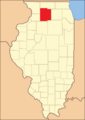
Ogle County between 1836 and 1839
-
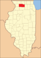
Ogle County after 1839, when Lee County was formed


Geography and Climate
According to the US Census Bureau, Ogle County covers a total area of 763 square miles. Most of this area, 759 square miles, is land. Only a small part, 4.4 square miles (0.6%), is water.
Neighboring Counties
Ogle County shares its borders with several other counties:
- Winnebago County to the north
- Boone County to the northeast
- Stephenson County to the northwest
- DeKalb County to the east
- Carroll County to the west
- Lee County to the south
- Whiteside County to the southwest
Weather in Ogle County
| Weather chart for Oregon, Illinois | |||||||||||||||||||||||||||||||||||||||||||||||
|---|---|---|---|---|---|---|---|---|---|---|---|---|---|---|---|---|---|---|---|---|---|---|---|---|---|---|---|---|---|---|---|---|---|---|---|---|---|---|---|---|---|---|---|---|---|---|---|
| J | F | M | A | M | J | J | A | S | O | N | D | ||||||||||||||||||||||||||||||||||||
|
1.6
26
10
|
1.4
32
15
|
2.6
44
27
|
3.6
58
37
|
4.3
70
48
|
4.9
79
58
|
3.5
82
62
|
4.5
80
60
|
3.3
73
51
|
2.7
62
39
|
2.8
45
28
|
2.1
31
17
|
||||||||||||||||||||||||||||||||||||
| temperatures in °F precipitation totals in inches source: The Weather Channel |
|||||||||||||||||||||||||||||||||||||||||||||||
|
Metric conversion
|
|||||||||||||||||||||||||||||||||||||||||||||||
In Oregon, the average temperatures change throughout the year. In January, it's usually around 10°F (about -12°C). In July, it gets warmer, with average highs around 82°F (about 28°C).
The coldest temperature ever recorded in January was -27°F (about -33°C) in 1999. The hottest temperature ever recorded was 110°F (about 43°C) in July 1936.
The amount of rain and snow also changes each month. February usually has the least precipitation, about 1.43 inches. June tends to be the wettest month, with about 4.88 inches.
Population and People
| Historical population | |||
|---|---|---|---|
| Census | Pop. | %± | |
| 1840 | 3,479 | — | |
| 1850 | 10,020 | 188.0% | |
| 1860 | 22,888 | 128.4% | |
| 1870 | 27,492 | 20.1% | |
| 1880 | 29,937 | 8.9% | |
| 1890 | 28,710 | −4.1% | |
| 1900 | 29,129 | 1.5% | |
| 1910 | 27,864 | −4.3% | |
| 1920 | 26,830 | −3.7% | |
| 1930 | 28,118 | 4.8% | |
| 1940 | 29,869 | 6.2% | |
| 1950 | 33,429 | 11.9% | |
| 1960 | 38,106 | 14.0% | |
| 1970 | 42,867 | 12.5% | |
| 1980 | 46,338 | 8.1% | |
| 1990 | 45,957 | −0.8% | |
| 2000 | 51,032 | 11.0% | |
| 2010 | 53,497 | 4.8% | |
| 2020 | 51,788 | −3.2% | |
| 2023 (est.) | 51,265 | −4.2% | |
| US Decennial Census 1790-1960 1900-1990 1990-2000 2010 |
|||
In 2010, Ogle County had 53,497 people living in 20,856 homes. About 14,711 of these were families. The average number of people in a household was 2.54. The average family size was 3.01.
Most people in Ogle County are white (93.2%). Other groups include Black or African American (0.9%), Asian (0.5%), and American Indian (0.2%). About 8.9% of the population is of Hispanic or Latino background.
The average age of people in Ogle County in 2010 was 40.7 years. About 33.1% of homes had children under 18 living there.
The average income for a household in the county was $55,733. For families, the average income was $64,927. About 8.9% of all people in the county lived below the poverty line. This included 12.4% of those under 18 years old.
Economy of Ogle County
By the year 2000, most workers in Ogle County (65%) had white-collar jobs. These are jobs that usually involve office work or professional services. This was a big increase from 1990.
Manufacturing is still a very important job sector. It employs over 21.7% of the workers. However, this number has gone down since 1995. Experts think that service jobs might become the biggest employer after 2015.
Farming is also very important in Ogle County. The main crops grown are corn and soybeans. In 2003, Ogle County was ranked 17th in Illinois for money made from crops. It was also 14th for money made from livestock. While hog and pig farming is still a leader, the number of animals raised has decreased.
Ogle County has also received money for new projects. In 2006, a $180 million project was started to create a hub for moving cargo from trucks to trains. Also in 2006, a new ethanol production plant received $5.5 million from the state.
Transportation
Bus Services
- List of intercity bus stops in Illinois
Main Roads
Many important roads run through Ogle County:
 Interstate 39
 Interstate 88
 U.S. Highway 51
 U.S. Highway 52
 Illinois Route 2
 Illinois Route 26
 Illinois Route 38
 Illinois Route 64
 Illinois Route 72
 Illinois Route 110
 Illinois Route 251
Airports
There are two public airports in Ogle County:
- Ogle County Airport (C55) in Mount Morris, Illinois
- Rochelle Municipal Airport (RPJ) in Rochelle, Illinois
Railroads
Several major train lines pass through Ogle County. These include lines operated by Union Pacific, BNSF, and Canadian Pacific Kansas City.
Fun and Nature
Parks to Visit
Ogle County has several beautiful parks and natural areas:
- Castle Rock State Park
- Lowden State Park
- Lowden-Miller State Forest
- Sinnissippi Farms
- Weld Park
- White Pines State Park
Nature Preserves
These special areas protect natural habitats:
- Beach Cemetery Prairie Nature Preserve
- Douglas E. Wade Prairie Nature Preserve
- Jarrett Prairie Nature Preserve
- Nachusa Grasslands
Communities in Ogle County
Cities
Villages
Unincorporated Communities
These are smaller communities without their own local government:
- Baileyville
- Brookville
- Buffalo Grove
- Chana
- Daysville
- Egan
- Flagg
- Flagg Center
- Hazelhurst (partial)
- Holcomb
- Kings
- Lindenwood
- Paynes Point
- Stratford
- Woosung
Census-Designated Places
These are areas identified by the Census Bureau for statistical purposes:
Townships
Ogle County is divided into several townships:
- Brookville Township
- Buffalo Township
- Byron Township
- Dement Township
- Eagle Point Township
- Flagg Township
- Forreston Township
- Grand Detour Township
- Lafayette Township
- Leaf River Township
- Lincoln Township
- Lynnville Township
- Marion Township
- Maryland Township
- Monroe Township
- Mount Morris Township
- Oregon-Nashua Township
- Pine Creek Township
- Pine Rock Township
- Rockvale Township
- Scott Township
- Taylor Township
- White Rock Township
- Woosung Township
See also
 In Spanish: Condado de Ogle para niños
