
Winnebago County, Illinois facts for kids
Quick facts for kids
Winnebago County
|
||
|---|---|---|

Winnebago County Justice Center
|
||
|
||

Location within the U.S. state of Illinois
|
||
 Illinois's location within the U.S. |
||
| Country | ||
| State | ||
| Founded | January 16, 1836 | |
| Named for | Winnebago people | |
| Seat | Rockford | |
| Largest city | Rockford | |
| Area | ||
| • Total | 519 sq mi (1,340 km2) | |
| • Land | 513 sq mi (1,330 km2) | |
| • Water | 5.9 sq mi (15 km2) 1.1% | |
| Population
(2020)
|
||
| • Total | 285,350 | |
| • Estimate
(2023)
|
280,922 |
|
| • Density | 549.8/sq mi (212.28/km2) | |
| Time zone | UTC−6 (Central) | |
| • Summer (DST) | UTC−5 (CDT) | |
| Congressional districts | 16th, 17th | |

Winnebago County is a county in the state of Illinois, USA. In 2020, about 285,350 people lived here. This makes it the seventh largest county in Illinois by population. The main city and county seat is Rockford. Winnebago County is the center of the Rockford metropolitan area.
Contents
History of Winnebago County
Winnebago County was created on January 16, 1836. It was formed from parts of Jo Daviess and LaSalle counties. The county was named after the Winnebago Tribe of Native Americans.
When the county was first founded, most of its residents were "Yankee" settlers. These were people who came from New England or from upstate New York. They were descendants of the English Puritans who settled New England in the 1600s. These settlers made up almost all of Winnebago County's population for many years.
After the Black Hawk War ended, even more people moved here from New England. Because of this background, the people of Winnebago County saw themselves as part of the New England culture. In the 1860 presidential election, Abraham Lincoln received many more votes in Winnebago County than Stephen A. Douglas.
Geography of Winnebago County
Winnebago County covers a total area of about 519 square miles (1,344 km²). Most of this area, about 513 square miles (1,329 km²), is land. The remaining 5.9 square miles (15 km²), or 1.1%, is water.
Climate and Weather in Rockford
| Weather chart for Rockford, Illinois | |||||||||||||||||||||||||||||||||||||||||||||||
|---|---|---|---|---|---|---|---|---|---|---|---|---|---|---|---|---|---|---|---|---|---|---|---|---|---|---|---|---|---|---|---|---|---|---|---|---|---|---|---|---|---|---|---|---|---|---|---|
| J | F | M | A | M | J | J | A | S | O | N | D | ||||||||||||||||||||||||||||||||||||
|
1.4
27
11
|
1.3
33
16
|
2.4
46
27
|
3.6
59
37
|
4
71
48
|
4.8
80
58
|
4.1
83
63
|
4.2
81
61
|
3.5
74
52
|
2.6
62
40
|
2.6
46
29
|
2.1
32
17
|
||||||||||||||||||||||||||||||||||||
| temperatures in °F precipitation totals in inches source: The Weather Channel |
|||||||||||||||||||||||||||||||||||||||||||||||
|
Metric conversion
|
|||||||||||||||||||||||||||||||||||||||||||||||
In Rockford, the county seat, temperatures change a lot throughout the year. In January, the average low temperature is about 11°F (–12°C). In July, the average high temperature is about 83°F (28°C).
The coldest temperature ever recorded was –27°F (–33°C) in January 1982. The hottest was 112°F (44°C) in July 1936. The county gets the most rain in June, with about 4.80 inches (122 mm). February is usually the driest month.
Major Highways in Winnebago County
 Interstate 39
 Interstate 90
 U.S. Highway 20
 U.S. Highway 51
 Illinois Route 2
 Illinois Route 70
 Illinois Route 75
 Illinois Route 173
 Illinois Route 251
Public Transportation
- Beloit Transit
- Rockford Mass Transit District
- List of intercity bus stops in Illinois
Counties Next to Winnebago County
- Rock County, Wisconsin (north)
- Boone County (east)
- DeKalb County (southeast)
- Ogle County (south)
- Carroll County (southwest)
- Stephenson County (west)
- Green County, Wisconsin (northwest)
Population and People
| Historical population | |||
|---|---|---|---|
| Census | Pop. | %± | |
| 1840 | 4,609 | — | |
| 1850 | 11,773 | 155.4% | |
| 1860 | 24,491 | 108.0% | |
| 1870 | 29,301 | 19.6% | |
| 1880 | 30,505 | 4.1% | |
| 1890 | 39,938 | 30.9% | |
| 1900 | 47,845 | 19.8% | |
| 1910 | 63,153 | 32.0% | |
| 1920 | 90,929 | 44.0% | |
| 1930 | 117,373 | 29.1% | |
| 1940 | 121,178 | 3.2% | |
| 1950 | 152,385 | 25.8% | |
| 1960 | 209,765 | 37.7% | |
| 1970 | 246,623 | 17.6% | |
| 1980 | 250,884 | 1.7% | |
| 1990 | 252,913 | 0.8% | |
| 2000 | 278,418 | 10.1% | |
| 2010 | 295,266 | 6.1% | |
| 2020 | 285,350 | −3.4% | |
| 2023 (est.) | 280,922 | −4.9% | |
| U.S. Decennial Census 1790–1960 1900–1990 1990–2000 2010–2019 |
|||
The population of Winnebago County has changed over time. The table below shows the different racial and ethnic groups living in the county. The US Census counts people of Hispanic/Latino origin separately from racial categories.
| Race / Ethnicity (NH = Non-Hispanic) | Pop 2000 | Pop 2010 | Pop 2020 | % 2000 | % 2010 | % 2020 |
|---|---|---|---|---|---|---|
| White alone (NH) | 220,817 | 214,196 | 183,235 | 79.31% | 72.54% | 64.21% |
| Black or African American alone (NH) | 29,038 | 35,358 | 38,240 | 10.43% | 11.97% | 13.40% |
| Native American or Alaska Native alone (NH) | 584 | 563 | 559 | 0.21% | 0.19% | 0.20% |
| Asian alone (NH) | 4,719 | 6,722 | 7,938 | 1.69% | 2.28% | 2.78% |
| Pacific Islander alone (NH) | 76 | 61 | 66 | 0.03% | 0.02% | 0.02% |
| Other race alone (NH) | 216 | 319 | 1,099 | 0.08% | 0.11% | 0.39% |
| Mixed race or Multiracial (NH) | 3,762 | 5,870 | 13,261 | 1.35% | 1.99% | 4.65% |
| Hispanic or Latino (any race) | 19,206 | 32,177 | 40,952 | 6.90% | 10.90% | 14.35% |
| Total | 278,418 | 295,266 | 285,350 | 100.00% | 100.00% | 100.00% |
In 2010, there were 295,266 people living in the county. There were 115,501 households and 76,854 families. The population density was about 575 people per square mile.
About 33.1% of households had children under 18. About 47.3% were married couples. The average household had 2.52 people. The average family had 3.07 people. The average age of people in the county was 38.3 years.
The average income for a household was $47,198. For a family, it was $59,814. About 15.9% of the population lived below the poverty line. This included 25.0% of those under 18.
Communities in Winnebago County
Winnebago County has several cities, villages, and other communities.
Cities
Villages
- Cherry Valley
- Durand
- Machesney Park
- New Milford
- Pecatonica
- Rockton
- Roscoe
- Winnebago
Census-designated place
Unincorporated Communities
Townships
Winnebago County is divided into these townships:
- Burritt
- Cherry Valley
- Durand
- Harlem
- Harrison
- Laona
- Owen
- Pecatonica
- Rockford
- Rockton
- Roscoe
- Seward
- Shirland
- Winnebago
Former Settlement
Images for kids
-
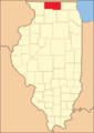
Winnebago County in its first year (1836)
-
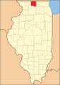
Winnebago County in 1837, after new counties were created


See also
 In Spanish: Condado de Winnebago (Illinois) para niños
