Durand, Illinois facts for kids
Quick facts for kids
Durand
|
|
|---|---|
| Village of Durand | |

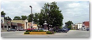
Downtown Durand
|
|
| Nickname(s):
Village of Volunteers
|
|

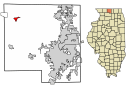
Location of Durand in Winnebago County, Illinois.
|
|

Location of Illinois in the United States
|
|
| Country | United States |
| State | Illinois |
| County | Winnebago |
| Township | Durand |
| Area | |
| • Total | 0.92 sq mi (2.38 km2) |
| • Land | 0.92 sq mi (2.38 km2) |
| • Water | 0.00 sq mi (0.00 km2) |
| Elevation | 778 ft (237 m) |
| Population
(2020)
|
|
| • Total | 1,390 |
| • Density | 1,512.51/sq mi (584.02/km2) |
| Time zone | UTC-6 (CST) |
| • Summer (DST) | UTC-5 (CDT) |
| ZIP Code(s) |
61024
|
| Area code(s) | 815 |
| FIPS code | 17-21280 |
| GNIS ID(s) | 407516, 2398762 |
| Wikimedia Commons | Durand, Illinois |
Durand is a small village located in Winnebago County, Illinois, United States. It's part of the larger Rockford area. In 2010, about 1,443 people lived here. By 2020, the population was 1,390.
Contents
History of Durand Village
The area where Durand is now began with a settlement called Elton in 1835. Early settlers included Nelson Salisbury, Harvey Lower, and Scott Robb. They, along with nine other families, settled in the southwestern part of what is now Durand.
Durand is known for having Illinois' first volunteer fire department that was supported by taxes. The village has faced many fires throughout its history.
Durand's growth was closely tied to the Racine-Mississippi Railroad. This railroad line reached Durand in 1857. It was on its way to Freeport, Illinois. The arrival of the railroad helped shift the community from Elton to the modern village of Durand. The village was named after H.S. Durand, who was the first president of the railroad. This marked the beginning of Durand's success and the end of the Elton settlement.
Geography and Location
Durand is located at coordinates 42°26′2″N 89°19′41″W / 42.43389°N 89.32806°W. It is about 14 miles north of US Route 20. You can reach it by taking Illinois Route 70. Illinois Route 75 also passes south of the town.
According to the 2010 census, Durand covers an area of about 0.94 square miles (2.4 square kilometers). All of this area is land.
Population and People
| Historical population | |||
|---|---|---|---|
| Census | Pop. | %± | |
| 1880 | 530 | — | |
| 1890 | 489 | −7.7% | |
| 1900 | 571 | 16.8% | |
| 1910 | 527 | −7.7% | |
| 1920 | 549 | 4.2% | |
| 1930 | 554 | 0.9% | |
| 1940 | 592 | 6.9% | |
| 1950 | 679 | 14.7% | |
| 1960 | 797 | 17.4% | |
| 1970 | 972 | 22.0% | |
| 1980 | 1,073 | 10.4% | |
| 1990 | 1,100 | 2.5% | |
| 2000 | 1,081 | −1.7% | |
| 2010 | 1,443 | 33.5% | |
| 2020 | 1,390 | −3.7% | |
| U.S. Decennial Census | |||
In 2000, there were 1,081 people living in Durand. There were 441 households and 288 families. The population density was about 1,200 people per square mile.
About 28.9% of the population was under 18 years old. About 13.6% of the population was 65 years old or older. The average age in the village was 36 years. For every 100 females, there were about 92 males.
Famous People from Durand
- Carrie Ashton Johnson (1863–1949), an editor and author.
See also
 In Spanish: Durand (Illinois) para niños
 | Selma Burke |
 | Pauline Powell Burns |
 | Frederick J. Brown |
 | Robert Blackburn |

