Illinois Route 2 facts for kids
Quick facts for kids
Illinois Route 2 |
||||
|---|---|---|---|---|
|
IL 2 highlighted in red
|
||||
| Route information | ||||
| Maintained by IDOT | ||||
| Length | 73.91 mi (118.95 km) | |||
| Existed | November 5, 1918–present | |||
| Major junctions | ||||
| South end | ||||
| North end | ||||
| Location | ||||
| Counties: | Whiteside, Lee, Ogle, Winnebago | |||
| Highway system | ||||
| Illinois state highway system Illinois Tollway system
|
||||
Illinois Route 2 (IL 2) is a state road in northern Illinois. It runs from Illinois Route 40 in Sterling in the south. It goes all the way north to the Wisconsin state line in South Beloit. This road is about 74 miles (119 kilometers) long. It follows the path of the Rock River for much of its journey.
Contents
Exploring Illinois Route 2: A Scenic Drive
Illinois Route 2 used to follow the Rock River from Rock Island to South Beloit. In the 1800s, this route was important for trading. People used it to move goods between Rockford and Rock Island. The Rock River itself was not easy for boats to use for trading. This was because it was only deep enough west of Rock Falls.
Today, bigger highways like Interstate 39 and Interstate 88 are used for most long-distance travel. However, the original path of Illinois Route 2 is still there. It offers a more local and scenic drive.
Starting in Sterling and Heading North
In Sterling, IL 2 begins as two separate one-way roads. These roads come together near the Sinnissippi Mounds. After this, it becomes a single two-way road. From Sterling to Dixon, IL 2 mostly follows part of the historic Lincoln Highway. There is one small difference. The Lincoln Highway briefly turns away northeast to Palmyra. It then comes back to IL 2 just northwest of Dixon.
Just north of Dixon, IL 2 shares the road with U.S. Route 52 and Illinois Route 26. They all cross the Rock River to reach downtown Dixon. In downtown Dixon, IL 2 turns northeast and separates from the other two routes.
Journeying Through Parks and Towns
At a place called Grand Detour, IL 2 crosses a bridge. This bridge moves the road from one side of the Rock River to the other. Further north, the route goes through Castle Rock State Park. It also passes Illinois Route 64 in Oregon, near the Ogle County Courthouse. In Byron, IL 2 briefly shares the road with Illinois Route 72.
North of the Chicago Rockford International Airport, IL 2 turns directly north. From this point, it runs mostly parallel to Illinois Route 251. IL 251 is located east of the river. IL 2 then meets U.S. Route 20 at a special road crossing called a diamond interchange. This used to be a different type of crossing.
As IL 2 gets closer to downtown Rockford, the road splits again. If you are driving north, you stay on Main Street. Then you turn east onto Chestnut Street (which is also U.S. Route 20 Business). After that, you turn north on Wyman Street. Then you go west on Park Avenue, near the Beattie Park Mound Group. Finally, you turn back north on Main Street before the roads merge again.
If you are driving south, you turn west onto John Street. Then you go south on Church Street. After that, you turn east on Cedar Street before the roads merge.
Reaching the Wisconsin Border
In Rockton, IL 2 crosses the river again. It moves from the west side to the east side. Further north, Illinois Route 75 shares the road with IL 2 from Rockton to South Beloit. Before IL 2 changes into WIS 213 at the state line, IL 75 turns off to the east. Then, IL 2 crosses a railroad track and a stream called Turtle Creek. It continues a bit further until it reaches the Wisconsin state line.
History of Illinois Route 2
The original Illinois Route 2, known as SBI Route 2, was much longer. It ran all the way from South Beloit down to Cairo. It followed part of today's IL 2 from South Beloit to Dixon. Then it went south on roads that are now roughly U.S. Route 52, Illinois Route 251, and U.S. Route 51.
In 1935, U.S. Route 51 took over the part of IL 2 south of Mendota. When U.S. Route 52 appeared in 1936, IL 2 was removed south of Dixon. For a short time in 1938, IL 2 was extended to Muscatine, Iowa. It replaced other routes like IL 84 and IL 86. But it was cut back to Rock Island in 1939. This happened after Illinois Route 92 was extended to Muscatine. By the late 1970s, IL 2 was removed west of Sterling. This was because Illinois Route 5 (now I-88 east of Interstate 80) was extended to Rock Island.
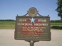
Illinois Route 2 was given a special name on November 4, 1970. It was called a Blue Star Memorial Highway. This name honors the U.S. armed forces. You can find a sign for it in a rest area just west of the Winnebago County line. This sign is in Ogle County, along the Rock River.
See also
 In Spanish: Ruta de Illinois 2 para niños
 | Sharif Bey |
 | Hale Woodruff |
 | Richmond Barthé |
 | Purvis Young |


