
Illinois Route 92 facts for kids
Quick facts for kids
|
||||
|---|---|---|---|---|
|
IL 92 highlighted in red
|
||||
| Route information | ||||
| Maintained by IDOT | ||||
| Length | 106.41 mi (171.25 km)
Length includes portions of route that are run on one-way streets, resulting in a double-counting of this mileage.
|
|||
| Existed | 1939–present | |||
| Major junctions | ||||
| West end | ||||
| East end | ||||
| Location | ||||
| Counties: | Rock Island, Henry, Bureau | |||
| Highway system | ||||
| Illinois state highway system Illinois Tollway system
|
||||

Illinois Route 92 (also called IL 92 or Route 92) is an important road in northwest Illinois. It runs from west to east, starting at the Norbert F. Beckey Bridge over the Mississippi River. Here, it connects with Iowa Highway 92. The road then travels east all the way to U.S. Route 34 in La Moille.
This journey covers about 106.41 miles (171.25 kilometers). Interestingly, Illinois Route 92 is part of a much longer "Highway 92" that stretches across four states! This big highway is about 886 miles (1,426 kilometers) long. It begins in Torrington, Wyoming, passes through Nebraska and Iowa, and finally ends in La Moille, Illinois.
Contents
Exploring Illinois Route 92

Illinois Route 92 starts on the Norbert F. Beckey Bridge, which crosses the mighty Mississippi River. From there, it heads east through wide, open farmland.
Soon, it meets Illinois Route 192, which used to be part of Route 92. At this point, IL 92 turns north and follows the eastern bank of the Mississippi River through a town called Andalusia. This part of the road sometimes gets flooded, so IL 192 is used as a detour when that happens. In Andalusia, you can find the Ski Snowstar winter sports park, a fun place for skiing and snowboarding!
After Andalusia, the road turns north again and becomes known as the Centennial Expressway. It then crosses Interstate 280 and enters the busy downtown area of Rock Island.
Through the Quad Cities

In Rock Island, the Centennial Expressway ends where it meets U.S. Route 67. This is also near the Rock Island Centennial Bridge. Route 92 continues east through the downtown areas of Rock Island, Moline, and East Moline. Some parts of the road here are set up as one-way streets.
In downtown Moline, Route 92 crosses paths with Interstate 74 and U.S. Route 6. These roads meet at the I-74 Bridge over the Mississippi. As Route 92 moves between East Moline and Silvis, it joins up with Illinois Route 84 for a while.
In Carbon Cliff, Route 92 turns northeast and becomes an expressway, sharing the road with Illinois Route 5. Then, at an interchange with Interstate 80, Route 5 ends. Route 92 continues as a freeway, joining Interstate 88 and Illinois Route 110 (which is also known as the Chicago-Kansas City Expressway).
Journey to La Moille

Illinois Route 92 travels with I-88 and IL 110 for about 6 miles (9.7 kilometers). After that, IL 92 leaves them at I-88 Exit 6 and continues heading east on its own.
This part of the road takes you through beautiful, rich farmland in Illinois. It crosses the Rock River and the historic Hennepin Canal. The canal is a cool place to visit, with trails for hiking and biking.
Route 92 then briefly turns north, sharing the road with Illinois Route 78. It passes through the small towns of Walnut and Ohio. Finally, Illinois Route 92 ends when it meets U.S. Route 34 in La Moille.

Images for kids
-
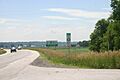
Illinois Route 92 enters Illinois from Iowa.
-
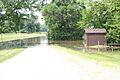
A park along the Mississippi River on Illinois Route 92 in Andalusia, Illinois.
-
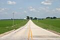
Illinois Route 92 travels through the rich farmland of western Illinois.
-
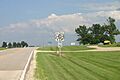
A sign marking the eastern end of IL-92 and the four-state Route 92 in La Moille, Illinois.
See also
 In Spanish: Ruta de Illinois 92 para niños
