
Hennepin Canal Parkway State Park facts for kids
Quick facts for kids Hennepin Canal State Trail |
|
|---|---|
|
IUCN Category III (Natural Monument)
|
|

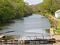
Hennepin Canal Lock #1 on February 13, 2004. The Illinois Department of Natural Resources claims that this lock has been under water since the 1930s.
|
|

Hennepin Canal State Trail
Location in Illinois
|
|
| Location | Rock Island, Bureau, Henry, Lee, and Whiteside Counties, Illinois, USA |
| Nearest city | Sheffield, Illinois |
| Length | Main canal length: 75.2 miles (121.0 km); feeder canal length: 29.3 miles (47.2 km) |
| Established | August 1, 1970 |
| Governing body | Illinois Department of Natural Resources |
|
Hennepin Canal Historic District
|
|
| Built | 1890 – 1907 |
| Architect | U.S. Corps of Engineers |
| NRHP reference No. | 78003433 |
| Added to NRHP | May 22, 1978 |
The Hennepin Canal State Trail, also known as the Hennepin Canal, is an old waterway in northwest Illinois. It connects the Mississippi River near Rock Island to the Illinois River close to Hennepin. This entire canal is a special historic place, listed on the National Register of Historic Places.
The canal opened in 1907 but was soon used less because trains became a better way to move goods. Later, it was brought back to life as a fun place for outdoor activities. Its old name was the Illinois and Mississippi Canal. The main part of the canal is about 75 miles long. There's also a smaller "feeder" canal that is about 29 miles long. This state park stretches across five counties in Illinois and is about 104.5 miles long in total.
Contents
The Canal's Journey: From Idea to Trail
The idea for the Hennepin Canal first came up in 1834. People wanted a way to connect the Illinois and Mississippi Rivers. But money problems in Illinois delayed many big building projects.
Why Was the Canal Built?
People wanted cheaper ways to transport goods than by train. So, in 1871, the government started looking into building the canal. Construction finally began in 1892. The first boat traveled through the canal in 1907. This canal made the trip for barges from Chicago to Rock Island much shorter, saving about 419 miles.
However, while the canal was being built, the locks on the Illinois and Mississippi Rivers were made much wider. This meant the Hennepin Canal's locks were too small even before it fully opened!
Early Days and Challenges
By the 1930s, the Hennepin Canal was mostly used for fun boat trips. It was free to use for boats until 1951. In winter, ice from the canal was even sold to help pay for its upkeep.
The Hennepin Canal was special because it was the first American canal built using concrete, not just cut stone. This new way of building helped engineers learn new skills. These skills were later used for other big projects, like the Panama Canal. Both canals used concrete locks and a special "feeder" canal from a man-made lake to keep them filled with water, even when the water needed to flow uphill.
Locks and Aqueducts
The canal has 33 locks. Locks are like water elevators that help boats move up or down between different water levels. All of them can be seen today. One lock, Lock #1, was underwater from the 1930s until recently. You can only reach it on foot in winter.
Fourteen of the locks had special "Marshall gates." These gates were unique to the Hennepin Canal and moved up and down on a horizontal bar. Five of the locks have been fixed up, but they are not used for boats anymore. The gates on the other locks have been replaced with concrete walls, which now create small waterfalls.
The Hennepin Canal also had nine aqueducts. These were like concrete bridges that carried the canal and its boats over other rivers and streams. Six of these aqueducts are still there. The other three were replaced with pipes that carry the canal's water under the streams.
Planning and Building the Canal

.jpg)


The main goal of building the Hennepin Canal was to lower the cost of shipping goods. Many people and government officials worked hard to make it happen. The idea was to create a fast route from Chicago to the Mississippi River.
Interest in the canal grew during the American Civil War. People worried that if the U.S. went to war with the UK, the Saint Lawrence River and Welland Canal might close. This would stop people from the Great Lakes area from selling their goods in eastern markets. But since war didn't happen, many people lost interest.
Illinois wouldn't pay for the canal itself. So, groups from Iowa, Illinois, and New York tried to get the government to fund it. In 1868, Ulysses S. Grant from Illinois became president. This helped get the federal government to pay attention. The first government survey was done in 1870.
A group called the Hennepin Canal Commission was formed in 1881. They wanted to show how important the canal was for the whole country. They believed a canal would help control how much railroads charged for shipping.
Several routes were looked at for the canal. The eastern part of all routes was the same, starting near Hennepin. The main difference was where the canal would end in the west. In 1886, a group of engineers suggested the "Marais d’Osier" route. But this route was later changed to the "Rock Island" route. Rock Island was chosen because it had more people and a busy river port.
Even after all the planning, construction didn't start right away. But in 1890, Congress gave $500,000 to begin building the first five miles.
The Feeder Canal
One big part of the plan was the "feeder canal." This canal would bring water from the Rock River into the main canal. The question was where to build it. It was decided that tapping the river at Rock Falls would be shorter and cheaper than at Dixon. So, the feeder canal was built at Rock Falls.
Construction of the Hennepin Canal officially began on September 19, 1890. The estimated cost was about $6.9 million. Since railroads already existed, many bridges had to be built. This included eight railroad bridges and 67 highway bridges, which caused delays.
The engineers asked to use concrete for the locks, which was unusual at the time. Most locks were made of cut stone. But in 1891, permission was given to use concrete. This saved a lot of money, about 50% less than stone. This allowed the locks to be built five feet wider.
Workers found a peat bog, a swampy area, for three miles. So, the canal bed had to be lined with clay to stop water from leaking out. In 1894, work started on the eastern half. This part was the hardest because the canal had to go up 196 feet from sea level. This needed 21 locks to control the water flow. In total, there were 32 locks on the main canal.
All the locks were 170 feet long and 35 feet wide. They could handle barges up to 140 feet long. However, the average barge at the time was twice that size and needed deeper water than the canal's six-foot depth. The feeder canal had one lock, called the guard lock. It protected the canal from high river water. All 33 locks were operated by hand.
By 1907, a dam at Rock Falls was the last major project. It was 1335 feet long and made the water rise 11.5 feet above normal. This flooded about 1936 acres of land. The feeder canal runs almost straight south for 29.3 miles, and the main canal is 75 miles long.
The First Trip
On October 24, 1907, a huge crowd gathered in Rock Falls for the canal's opening. There was a street parade and a boat parade. The canal was finished on October 21, 1907. The first boat to travel the entire length was the steamer Marion, carrying government officials. It left on November 8 and returned on November 15. The canal wasn't completely full of water, so water had to be moved section by section using the locks. The boat even had to break through ice. When it reached the end, there was too much water to pass under the Rock Island Bridge. So, sailors had to ask people to come aboard to make the ship sink a little!
Guests at the opening included Governor Charles S. Deneen. Miss Grace Wheeler, the chief engineer's daughter, opened the gates for the first time.
Decline and New Life
The early years of the canal were tough, especially with the start of the Great Depression in 1930. The amount of goods shipped on the canal dropped by 40 percent. A telephone system was built so lock operators knew when a boat was coming. Some of the old telephone poles are still standing today.
The canal was used to transport coal, salt, grain, and other goods. But it was also a place for fun! Families had picnics, went swimming, and especially enjoyed fishing. Fish caught in the Hennepin Canal still hold Illinois records. Local YMCAs even held swimming classes there.
The Corps of Engineers had about 50 full-time workers to run and maintain the canal. They lived in houses along the canal, which had concrete paths but no electricity or indoor plumbing.
Even though the canal wasn't as successful for shipping as planned, it still helped. In 1920, a barge line started, shipping gravel, steel, and coal.
Many people felt the canal was too small and old-fashioned even when it was built. It was meant to connect the Upper Mississippi River Valley to the Atlantic Ocean, but it didn't really achieve that. However, it did help farmers by giving them another option besides expensive railroad shipping. By 1948, there was almost no traffic on the canal.
It would have cost $12 million to make the canal bigger and deeper. So, in 1951, all lock operations and non-essential maintenance stopped. People in Illinois and conservation groups started campaigns to "Save the Canal." They sent many letters and petitions to lawmakers.
Finally, on August 1, 1970, the state of Illinois took over the canal. It became a place for recreation under the Department of Conservation.
Geography
The Hennepin Canal follows a naturally low area between Hennepin and Rock Island. This area was once the old path of the Mississippi River! Long ago, about 300,000 to 132,000 years ago, a big ice age blocked the Mississippi River near Rock Island. This forced the river to change its path to where it flows today.
The Canal Today
Today, the Hennepin Canal is a popular spot for outdoor activities. A paved trail runs along the entire length of the canal. People can walk, jog, or bike on it. In the winter, it's a great place for snowmobiling. Fishing is still very popular, but swimming is not allowed. From its beginnings in 1834 to its closure for shipping in 1951, the canal has always been a place for both work and play.
Images for kids
-
Hennepin Feeder Canal, looking south from its origin on the Rock River in Rock Falls, Illinois.

