Sheffield, Illinois facts for kids
Quick facts for kids
Sheffield
|
|
|---|---|

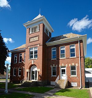
Village Hall at 239 South Main Street
|
|

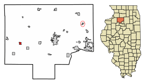
Location of Sheffield in Bureau County, Illinois.
|
|

Location of Illinois in the United States
|
|
| Country | United States |
| State | Illinois |
| County | Bureau |
| Townships | Concord, Mineral |
| Area | |
| • Total | 1.169 sq mi (3.03 km2) |
| • Land | 1.169 sq mi (3.03 km2) |
| • Water | 0.00 sq mi (0 km2) 0% |
| Population
(2020)
|
|
| • Total | 821 |
| • Density | 702.3/sq mi (271.16/km2) |
| Time zone | UTC-6 (CST) |
| • Summer (DST) | UTC-5 (CDT) |
| ZIP Code(s) |
61361
|
| Area code(s) | 815 |
| FIPS code | 17-69147 |
| Wikimedia Commons | Sheffield, Illinois |
Sheffield is a small village located in Bureau County, Illinois, United States. In 2020, about 821 people lived there. It is considered part of the larger Ottawa area.
Sheffield was started in 1852 by two men, Joseph E. Sheffield and Henry Farnam. They were building the Chicago and Rock Island Railroad. The village was planned as a place where trains could stop to get more coal. It's said that Sheffield and Farnam flipped a coin to decide whose name the town would carry! Today, you can find a monument in Sheffield's town square honoring Joseph E. Sheffield and the Rock Island Railroad.
Contents
Where is Sheffield Located?
Sheffield is in Illinois, a state in the United States. It covers a total area of about 1.17 square miles (3.03 square kilometers). All of this area is land, meaning there are no large lakes or rivers within the village limits.
How Many People Live in Sheffield?
The number of people living in Sheffield has changed over the years. Here's a quick look at the population from past censuses:
| Historical population | |||
|---|---|---|---|
| Census | Pop. | %± | |
| 1860 | 706 | — | |
| 1870 | 771 | 9.2% | |
| 1880 | 905 | 17.4% | |
| 1890 | 993 | 9.7% | |
| 1900 | 1,265 | 27.4% | |
| 1910 | 1,009 | −20.2% | |
| 1920 | 996 | −1.3% | |
| 1930 | 941 | −5.5% | |
| 1940 | 948 | 0.7% | |
| 1950 | 995 | 5.0% | |
| 1960 | 1,078 | 8.3% | |
| 1970 | 1,038 | −3.7% | |
| 1980 | 1,130 | 8.9% | |
| 1990 | 951 | −15.8% | |
| 2000 | 946 | −0.5% | |
| 2010 | 926 | −2.1% | |
| 2020 | 821 | −11.3% | |
| U.S. Decennial Census | |||
In 2020, the village had 821 residents. There were 369 households and 218 families living in Sheffield. Most people living in the village (about 95%) were White. A small percentage (around 2.5%) were Hispanic or Latino.
About 19.3% of the people in Sheffield were under 18 years old. Around 21.1% were 65 years old or older. The average age in the village was 44.5 years.
Who Are Some Famous People From Sheffield?
Sheffield has been home to a few notable individuals:
- Red Gunkel - A baseball pitcher who played for the Cleveland Indians.
- Olive Percival (1868-1945) - A writer known for her works on gardening.
- Clayton C. Pervier (1857–1929) - An Illinois politician, farmer, and newspaper editor.
- Jason Ringenberg - A musician.
- Riley Cole - A successful business person who grew up in Sheffield.
See also
 In Spanish: Sheffield (Illinois) para niños
 | Stephanie Wilson |
 | Charles Bolden |
 | Ronald McNair |
 | Frederick D. Gregory |

