
Interstate 39 facts for kids
Interstate 39 (I-39) is an important highway in the United States. It helps people travel a long distance through the middle of the country. This highway starts in Normal, Illinois, and goes north all the way to Rothschild, Wisconsin. It is about 306 miles (493 kilometers) long.
Quick facts for kids
|
|||||||||
|---|---|---|---|---|---|---|---|---|---|
| Lua error in Module:Infobox_road/map at line 15: attempt to index field 'wikibase' (a nil value).
I-39 highlighted in red
|
|||||||||
| Route information | |||||||||
| Maintained by IDOT and WisDOT | |||||||||
| Length | 306.14 mi (492.68 km) | ||||||||
| Major junctions | |||||||||
| South end | |||||||||
|
|||||||||
| North end | |||||||||
| Location | |||||||||
| States: | Illinois, Wisconsin | ||||||||
| Counties: | IL: McLean, Woodford, Marshall, LaSalle, Lee, Ogle, Winnebago WI: Rock, Dane, Columbia, Marquette, Waushara, Portage, Marathon |
||||||||
| Highway system | |||||||||
| Main route of the Interstate Highway System Main • Auxiliary • Business Illinois state highway system Illinois Tollway systemWisconsin highways County • Bannered • Rustic
|
|||||||||

Contents
Interstate 39: Connecting Illinois and Wisconsin
Interstate 39 is a major highway that helps people travel across the Midwest. It connects the central part of Illinois to the northern part of Wisconsin. This road is important for both everyday travel and moving goods.
What is an Interstate Highway?
An Interstate Highway is a special kind of road. These roads are part of a big network across the United States. They are designed for fast and smooth travel. They help connect cities and states. The Interstate Highway System makes it easier to travel long distances. These highways are usually well-maintained. They have specific rules for how they are built. This helps keep drivers safe.
Where Does I-39 Travel?
Interstate 39 goes through two states. It starts in Illinois and then crosses into Wisconsin. It connects many important towns and cities along its route. The highway is managed by the transportation departments of both states. These are the Illinois Department of Transportation (IDOT) and the Wisconsin Department of Transportation (WisDOT).
I-39 in Illinois
In Illinois, I-39 begins in Normal, Illinois. This is where it meets other major highways like I-55 and I-74. As it heads north, it passes through several counties. These include McLean, LaSalle, and Winnebago counties. Along the way, I-39 connects with other important roads. For example, it meets I-80 near LaSalle, Illinois. It also connects with I-88 near Rochelle, Illinois. Near Rockford, Illinois, it joins with I-90. Rockford is a large city in northern Illinois.
I-39 in Wisconsin
After crossing the state line, I-39 enters Wisconsin. It passes through counties like Rock, Dane, and Marathon. In Wisconsin, I-39 often shares its path with other highways. For instance, it runs together with I-90 and I-94 for a long stretch. This shared path helps drivers navigate easily. It passes through cities like Beloit, Wisconsin and Madison, Wisconsin. Madison is the capital city of Wisconsin. The highway finally ends in Rothschild, Wisconsin. This is where it meets US 51 and WI 29.
Important Cities Along the Way
I-39 connects many communities. It helps people travel between them for work, school, or fun.
- Normal, Illinois: This is where I-39 begins. It is a college town.
- LaSalle, Illinois: I-39 crosses I-80 near this city.
- Rochelle, Illinois: This city is known for its transportation hubs.
- Rockford, Illinois: A major city in northern Illinois. I-39 joins I-90 here.
- Beloit, Wisconsin: One of the first cities I-39 reaches in Wisconsin.
- Madison, Wisconsin: The capital city of Wisconsin. I-39 passes through or near it.
- Portage, Wisconsin: I-39, I-90, and I-94 all meet near this city.
- Rothschild, Wisconsin: This is where I-39 ends its journey.
Images for kids
-
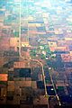
Aerial view of I-39 as it passes Minonk, Illinois, April 2012
-
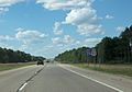
I-39/US 51 in northern Wisconsin


See also
 In Spanish: Interestatal 39 (Illinois) para niños
