Dane County, Wisconsin facts for kids
Quick facts for kids
Dane County
|
||
|---|---|---|
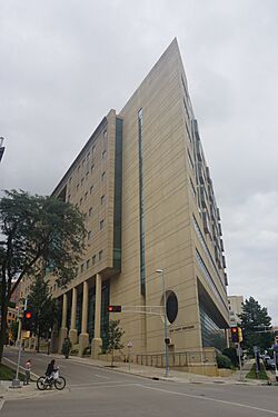
Dane County Courthouse
|
||
|
||
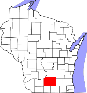
Location within the U.S. state of Wisconsin
|
||
 Wisconsin's location within the U.S. |
||
| Country | ||
| State | ||
| Founded | 1836 | |
| Named for | Nathan Dane | |
| Seat | Madison | |
| Largest city | Madison | |
| Area | ||
| • Total | 1,238 sq mi (3,210 km2) | |
| • Land | 1,197 sq mi (3,100 km2) | |
| • Water | 41 sq mi (110 km2) 3.3% | |
| Population
(2020)
|
||
| • Total | 561,504 | |
| • Estimate
(2023)
|
575,347 |
|
| • Density | 453.56/sq mi (175.12/km2) | |
| Time zone | UTC−6 (Central) | |
| • Summer (DST) | UTC−5 (CDT) | |
| Congressional district | 2nd | |
Dane County is a large area of land in the state of Wisconsin, USA. It is like a big neighborhood with many towns and cities. As of 2020, over 561,504 people live here. This makes it the second most populated county in Wisconsin.
The main city and government center of Dane County is Madison. Madison is also the capital city of Wisconsin! Dane County is the center of a larger area called the Madison metropolitan area.
Contents
History of Dane County
Dane County was created in 1836. It became an official county in 1839. The county was named after Nathan Dane. He was a important person from Massachusetts. Nathan Dane helped create the area that became Wisconsin. Settlers from New England started moving to Dane County in the 1840s.
Geography and Travel
Dane County covers about 1,238 square miles. Most of this area is land. About 41 square miles (3.3%) is water, like lakes and rivers.
Main Roads
Many important roads run through Dane County. These roads help people travel easily.
 Interstate 39
 Interstate 90
 Interstate 94
 U.S. Route 12
 U.S. Route 14
 U.S. Route 18
 U.S. Route 51
 U.S. Route 151
 Highway 19 (Wisconsin)
 Highway 30 (Wisconsin)
 Highway 69 (Wisconsin)
 Highway 73 (Wisconsin)
 Highway 78 (Wisconsin)
 Highway 89 (Wisconsin)
 Highway 92 (Wisconsin)
 Highway 104 (Wisconsin)
 Highway 106 (Wisconsin)
 Highway 113 (Wisconsin)
 Highway 134 (Wisconsin)
 Highway 138 (Wisconsin)
 Highway 188 (Wisconsin)
Trains and Buses
You can also travel by train or bus in Dane County.
- Freight Trains: Canadian Pacific and Wisconsin and Southern Railroad move goods by train.
- Local Buses: Madison Metro Transit and Monona Express help people get around cities.
- Long-Distance Buses: Companies like Van Galder and Greyhound Lines offer bus trips to other cities.
Airports
Dane County has airports for different kinds of flights.
- Commercial Airport: Dane County Regional Airport (MSN) is for bigger planes and passenger flights.
- Smaller Airports: Blackhawk Airfield, Middleton Municipal Airport, Verona Airport, and Waunakee Airport are for smaller, private planes.
Neighboring Counties
Dane County shares borders with seven other counties in Wisconsin:
- Columbia County (north)
- Dodge County (northeast)
- Green County (south)
- Iowa County (west)
- Jefferson County (east)
- Rock County (southeast)
- Sauk County (northwest)
Population and People
| Historical population | |||
|---|---|---|---|
| Census | Pop. | %± | |
| 1840 | 314 | — | |
| 1850 | 16,639 | 5,199.0% | |
| 1860 | 43,922 | 164.0% | |
| 1870 | 53,096 | 20.9% | |
| 1880 | 53,233 | 0.3% | |
| 1890 | 59,578 | 11.9% | |
| 1900 | 69,435 | 16.5% | |
| 1910 | 77,435 | 11.5% | |
| 1920 | 89,432 | 15.5% | |
| 1930 | 112,737 | 26.1% | |
| 1940 | 130,660 | 15.9% | |
| 1950 | 169,357 | 29.6% | |
| 1960 | 222,095 | 31.1% | |
| 1970 | 290,272 | 30.7% | |
| 1980 | 323,545 | 11.5% | |
| 1990 | 367,085 | 13.5% | |
| 2000 | 426,526 | 16.2% | |
| 2010 | 488,073 | 14.4% | |
| 2020 | 561,504 | 15.0% | |
| 2023 (est.) | 575,347 | 17.9% | |
| U.S. Decennial Census 1790–1960 1900–1990 1990–2000 2010–2020 2020 census |
|||
2020 Census Information
In 2020, Dane County had 561,504 people. The county had about 469 people per square mile. Most people (77.6%) were White. Other groups included Asian (6.4%), Black or African American (5.4%), and Native American (0.4%). About 7.5% of the population was Hispanic or Latino.
2010 Census Information
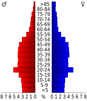
In 2010, there were 488,073 people living in Dane County. The average home had about 2.33 people. About 27% of homes had children under 18. The median age was 34.4 years old. This means half the people were younger and half were older than 34.4.
Religions in Dane County
Many different religious groups live in Dane County. In 2010, the largest groups were:
- Catholic (over 106,000 people)
- ELCA Lutheran (over 48,000 people)
- United Methodist (over 9,000 people)
Many other Christian groups and other faiths are also present.
Fun and Recreation
Dane County has many parks and places for outdoor activities.
County Parks
There are many county parks where you can enjoy nature.
- Babcock County Park
- Badger Prairie County Park
- Blooming Grove Drumlins
- Blue Mounds Natural Resource Area
- Brigham County Park
- CamRock County Park
- Cherokee Marsh
- Donald County Park
- Festge County Park
- Fish Camp County Park
- Fish Lake County Park
- Goodland County Park
- Halfway Prairie School
- Indian Lake County Park
- Jenni & Kyle Preserve
- La Follette County Park
- Lake Farm County Park
- Lake View Hill Park
- Lussier County Park
- McCarthy County Park
- Mendota County Park
- Phil's Woods County Park
- Prairie Moraine County Park
- Riley-Deppe County Park
- Salmo Pond County Park
- Scheidegger Forest
- Schumacher Farm
- Stewart Lake County Park
- Token Creek County Park
- Viking County Park
- Walking Iron County Park
- Yahara Heights County Park
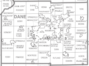
Communities in Dane County
Dane County has many different types of communities.
Cities
Cities are larger communities with their own local government. They usually have a mayor and offer many services.
- Edgerton (partly in Rock County)
- Fitchburg
- Madison (the main city)
- Middleton
- Monona
- Stoughton
- Sun Prairie (city)
- Verona
Villages
Villages are smaller than cities but still have their own local government. They are led by a Village President.
- Belleville (partly in Green County)
- Black Earth
- Blue Mounds
- Brooklyn (partly in Green County)
- Cambridge (partly in Jefferson County)
- Cottage Grove
- Cross Plains
- Dane
- Deerfield
- DeForest
- Maple Bluff
- Marshall
- Mazomanie
- McFarland
- Mount Horeb
- Oregon
- Rockdale
- Shorewood Hills
- Waunakee
- Windsor
Towns
Towns are rural areas that are not incorporated as cities or villages. They have a town board and offer fewer services.
- Albion
- Berry
- Black Earth (town)
- Blooming Grove
- Blue Mounds (town)
- Bristol
- Burke
- Christiana
- Cottage Grove (town)
- Cross Plains
- Dane
- Deerfield (town)
- Dunkirk
- Dunn
- Mazomanie (town)
- Medina
- Middleton (town)
- Montrose
- Oregon (town)
- Perry
- Pleasant Springs
- Primrose
- Roxbury
- Rutland
- Springdale
- Springfield
- Sun Prairie (town)
- Vermont
- Verona
- Vienna
- Westport
- York
Unincorporated Communities
These are smaller places that are part of a town. They often have a name but no separate government.
- Albion
- Aldens Corners
- Ashton
- Ashton Corners
- Bakers Corners
- Basco
- Burke
- Daleyville
- Deansville
- Door Creek
- Dunkirk
- East Bristol
- Elvers
- Five Points
- Forward
- Hanerville
- Highwood
- Hillside
- Hoffman Corners
- Indian Heights
- Kegonsa
- Kingsley Corners
- Klevenville
- London (partial)
- Lutheran Hill
- Martinsville
- Marxville
- Montrose
- Morrisonville
- Mt. Vernon
- Nora
- North Bristol
- Norway Grove
- Old Deerfield
- Paoli
- Pierceville
- Pine Bluff
- Primrose
- Riley
- Roxbury
- Rutland
- Seminary Springs
- Schey Acres
- Springfield Corners
- Stone
- Token Creek
- Utica
- Vermont
- Vilas
- West Middleton
- York Center
Neighborhoods
Neighborhoods are smaller parts of cities or villages. They are mainly for naming areas.
- Hope (Madison)
- Lake Windsor (Windsor)
- Fitchburg Center (Fitchburg)
- Middleton Junction (Madison)
- Oak Hall (Fitchburg)
Native American Community
- Ho-Chunk Indian Reservation is also located in Dane County.
Schools in Dane County
Many school districts serve students from kindergarten to 12th grade in Dane County.
- Barneveld School District
- Belleville School District
- Cambridge School District
- Columbus School District
- DeForest Area School District
- Deerfield Community School District
- Edgerton School District
- Evansville Community School District
- Fort Atkinson School District
- Lodi School District
- Madison Metropolitan School District
- Marshall School District
- McFarland School District
- Middleton-Cross Plains School District
- Monona Grove School District
- Mount Horeb Area School District
- Oregon School District
- Pecatonica Area School District
- Poynette School District
- River Valley School District
- Sauk Prairie School District
- Stoughton Area School District
- Sun Prairie Area School District
- Verona Area School District
- Waterloo School District
- Waunakee Community School District
- Wisconsin Heights School District
See also
 In Spanish: Condado de Dane para niños
 | James Van Der Zee |
 | Alma Thomas |
 | Ellis Wilson |
 | Margaret Taylor-Burroughs |


