McFarland, Wisconsin facts for kids
Quick facts for kids
McFarland
|
|
|---|---|
|
Village
|
|
| McFarland, Wisconsin | |
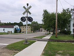
Downtown McFarland with its old railroad.
|
|
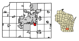
Location of McFarland in Dane County, Wisconsin.
|
|
| Country | |
| State | |
| County | Dane |
| Area | |
| • Total | 4.77 sq mi (12.34 km2) |
| • Land | 4.76 sq mi (12.33 km2) |
| • Water | 0.01 sq mi (0.02 km2) |
| Elevation | 869 ft (265 m) |
| Population
(2021)
|
|
| • Total | 9,325 |
| • Density | 1,897.67/sq mi (732.64/km2) |
| Time zone | UTC-6 (Central (CST)) |
| • Summer (DST) | UTC-5 (CDT) |
| Area code(s) | 608 |
| FIPS code | 55-46850 |
| GNIS feature ID | 1569214 |
McFarland is a village in Dane County, Wisconsin, United States. It is located right next to Lake Waubesa. In 2024, about 9,597 people lived there. McFarland is a suburb of Madison, which means it's a smaller town near a big city. It's part of the larger Madison area.
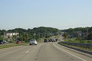
U.S. Route 51 is a main road that connects McFarland to Madison and Stoughton. The village's postal code is 53558. McFarland is the tenth largest place in Dane County by population.
Contents
History of McFarland
McFarland has a long history. You can find ancient burial mounds from the Woodland period in Indian Mound Park. These mounds are called the Lewis Mound Group.
The village was started in 1856 by William Hugh McFarland. In the early days, people farmed wheat and tobacco. They also harvested ice and fish from nearby Lake Waubesa. These goods were sent by train to markets in Chicago. Later, a small vacation area grew along Lake Waubesa. It had places like Edwards Park and Larson's Beach.
After World War II, McFarland became a place where people lived and commuted to work in Madison. In the late 1950s, the village added new petroleum tank farms. This helped the local school district get more money to build a new high school. Getting to Madison became much easier in 1989. A big highway project on the Madison Beltline was finished. This led to a lot of new homes being built in McFarland.
Geography and Location
McFarland is located at 43°1′7″N 89°17′28″W / 43.01861°N 89.29111°W.
The United States Census Bureau says the village covers about 3.55 square miles (9.20 square kilometers) of land. Lake Waubesa is to the west, and Mud Lake is to the south.
Time Zone Information
Like the rest of Wisconsin, McFarland is in the Central Time Zone.
People of McFarland (Demographics)
| Historical population | |||
|---|---|---|---|
| Census | Pop. | %± | |
| 1880 | 168 | — | |
| 1890 | 166 | −1.2% | |
| 1930 | 313 | — | |
| 1940 | 463 | 47.9% | |
| 1950 | 593 | 28.1% | |
| 1960 | 1,272 | 114.5% | |
| 1970 | 2,386 | 87.6% | |
| 1980 | 3,783 | 58.5% | |
| 1990 | 5,232 | 38.3% | |
| 2000 | 6,416 | 22.6% | |
| 2010 | 7,808 | 21.7% | |
| 2020 | 8,991 | 15.2% | |
| U.S. Decennial Census | |||
2010 Census Details
In 2010, there were 7,808 people living in McFarland. There were 3,079 households, and 2,201 families. The village had about 2,199 people per square mile (850 per square kilometer).
Most people (94.4%) were White. About 1.2% were African American, 0.4% Native American, and 1.7% Asian. About 2.3% of the population was Hispanic or Latino.
In 38.8% of homes, there were children under 18. Most homes (56.9%) had married couples. The average household had 2.54 people, and the average family had 2.96 people.
The average age in McFarland was 39.7 years. About 26.9% of residents were under 18. About 10.3% were 65 or older. There were slightly more females (51.0%) than males (49.0%).
Education in McFarland
The McFarland School District serves the village. It has several schools:
- Conrad Elvehjem Early Learning Center (Kindergarten)
- McFarland Primary School (grades 1–2)
- Waubesa Intermediate School (grades 3–5)
- Indian Mound Middle School (grades 6–8)
- McFarland High School
The schools in McFarland often score higher than the state average on tests. The district has also won awards for its programs.
Fun Events in McFarland
McFarland hosts many fun events throughout the year:
Summer Concert Series Enjoy live music from local bands at McDaniel Park during the summer.
Farmers Market Every Saturday morning from May to October, visit the McFarland Farmers' Market. You can find fresh produce, baked goods, and crafts from local sellers.
McFarland Community Festival Since 1985, McFarland has held a festival every September. It has carnival rides, train rides, a parade, and many fun competitions.
Winter Wonderland in the Village In the first week of December, the village celebrates Winter Wonderland. Events include open houses, scavenger hunts, carriage rides, Santa visits, and a parade.
Getting Around McFarland (Transportation)
McFarland is easy to get to. It's just south of US 12, which is Madison's "Beltline Highway."
- It's only 4 minutes from Interstate 90.
- It's 12 minutes from the Wisconsin State Capitol.
- It's 12 minutes from the University of Wisconsin.
The Dane County Regional Airport is about 12 miles north of McFarland. You can also find taxi companies, and ride-sharing services like Uber and Lyft in the village.
Railroad Lines
The Wisconsin and Southern train line crosses through the village.
Biking Trails
McFarland has several great biking trails. The Lower Yahara River Trail is about 2.5 miles long. It connects Madison to McFarland. This trail has North America's longest inland boardwalk bridge!
Public Bus Service
The northern part of McFarland is served by Madison Metro Transit Route L. This bus route connects to Madison's Owl Creek neighborhood.
Village Services
Fire Department and Emergency Services
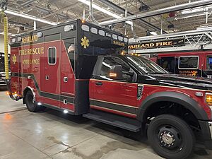
McFarland Fire Rescue is the community's fire department. It covers a large area of 14 square miles, including the village and nearby towns. They provide fire, rescue, and Paramedic services. The department started in 1908. Today, it has 68 paid-on-call firefighters and 9 full-time staff.
Law Enforcement
The Village has its own Police Department. They provide police services 24 hours a day. The McFarland Police Department has a Chief, a Lieutenant, 3 Sergeants, a Detective, an Investigator, and 10 Officers. They also have 2 office staff. The department has programs to connect with the community. They have a School Resource Officer, a Community Service Officer, and a K-9 Officer (a police dog!).
Public Library
The E.D. Locke Public Library serves the village. It is part of the South Central Library System. The library offers programs for kids and adults, help with research, and many books to borrow.
Media and News
McFarland gets news from Madison's TV, radio, and online sources. The local weekly newspaper is called the McFarland Thistle. Residents can also watch WMCF, a local public-access television channel.
Economy and Jobs
The McFarland School District and US Oil are two of the biggest employers in the village. Many people who live in McFarland also travel to Madison for their jobs.
Places to Visit (Attractions)
McFarland Historical Museum The McFarland Historical Museum is run by the McFarland Historical Society. They work to save and share the history of the village. The Museum and Log Cabin are open on Sundays from 1:00 p.m. to 4:00 p.m., from Memorial Day to September.
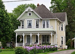
Larson House Museum The Larson House is a beautiful Victorian home built in 1898. It is in the Queen Anne style. You can take tours of the home on Sunday afternoons from 1 to 4 p.m., from Memorial Day to Labor Day.
McFarland Community Ice Arena This ice arena is run by a non-profit group. It hosts McFarland Youth Hockey, McFarland high school hockey, and other groups who want to skate.
Famous People from McFarland
- Realf Ottesen Brandt, a Lutheran minister
- Al Epperly, a professional baseball player (MLB)
- Conrad Elvehjem, a scientist who studied living things (biochemist)
- Brad Fischer, an adviser for the Pittsburgh Pirates baseball team
- Dominic Fumusa, an actor
- Matt and Becca Hamilton, Olympic curlers
- Doris Hanson, a Wisconsin politician
- Robert L. Hunt, a wildlife biologist who studied trout
- Steve Lacy, an Olympic runner in 1980 and 1984
- Helmar Lewis, a Wisconsin State Senator
- Theodore G. Lewis, a judge
- Nina Roth, an Olympic curler
- Jana Schneider, an actress and journalist
- Barbara Thompson, Wisconsin's Superintendent of Public Instruction
- Darrell "DJ" J. Krenz, an American Soldier and prisoner of war during the Korean War
See also
 In Spanish: McFarland (Wisconsin) para niños
 | Leon Lynch |
 | Milton P. Webster |
 | Ferdinand Smith |


