Rock County, Wisconsin facts for kids
Quick facts for kids
Rock County
|
||
|---|---|---|

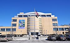
Rock County Courthouse
|
||
|
||

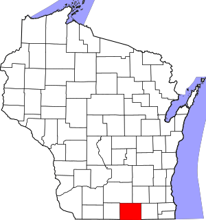
Location within the U.S. state of Wisconsin
|
||
 Wisconsin's location within the U.S. |
||
| Country | ||
| State | ||
| Founded | 1839 | |
| Named for | Rock River | |
| Seat | Janesville | |
| Largest city | Janesville | |
| Area | ||
| • Total | 726 sq mi (1,880 km2) | |
| • Land | 718 sq mi (1,860 km2) | |
| • Water | 8.0 sq mi (21 km2) 1.1%% | |
| Population
(2020)
|
||
| • Total | 163,687 | |
| • Estimate
(2023)
|
164,278 |
|
| • Density | 225.46/sq mi (87.05/km2) | |
| Time zone | UTC−6 (Central) | |
| • Summer (DST) | UTC−5 (CDT) | |
| Congressional districts | 1st, 2nd | |
Rock County is a county in the state of Wisconsin. It is located in the Midwest part of the United States. In 2020, about 163,687 people lived here.
The main city and county seat is Janesville. Rock County is part of a larger area that includes Janesville and Beloit. This area is important for jobs and community life.
Contents
History
Rock County was officially created on December 7, 1836. It was formed from a part of Milwaukee County. The county was fully set up on February 19, 1839.
The county gets its name from the Rock River. This river flows right through the middle of the county. It goes from the north to the south.
Geography
Rock County covers a total area of about 726 square miles. Most of this area is land, about 718 square miles. The rest, about 8.0 square miles, is water. This means about 1.1% of the county is water.
You can find the Cook Memorial Arboretum northwest of Janesville. An arboretum is like a park where many different kinds of trees and plants are grown. It has trails for walking and watching birds. The Janesville School District owns this natural area.
Transportation
Getting around Rock County is easy with many roads and other ways to travel.
Major highways
 Interstate 39
 Interstate 43
 Interstate 90
 U.S. Highway 12
 U.S. Highway 14
 U.S. Highway 51
 Highway 11
 Highway 26
 Highway 59
 Highway 67
 Highway 81
 Highway 89
 Highway 104
 Highway 138
 Highway 140
 Highway 213
Railroads
Trains also help move goods and people.
- Canadian Pacific
- Union Pacific
- Wisconsin and Southern Railroad
Buses
Local bus systems help people get around the cities.
- Beloit Transit
- Janesville Transit System
Airport
The Southern Wisconsin Regional Airport (KJVL) serves Rock County. It also helps nearby towns.
Adjacent counties
Rock County shares borders with several other counties:
- Green County – to the west
- Dane County – to the north
- Jefferson County – to the northeast
- Walworth County – to the east
- Boone County, Illinois – to the south
- Winnebago County, Illinois – to the south
Population Facts
| Historical population | |||
|---|---|---|---|
| Census | Pop. | %± | |
| 1840 | 1,701 | — | |
| 1850 | 20,750 | 1,119.9% | |
| 1860 | 36,690 | 76.8% | |
| 1870 | 39,030 | 6.4% | |
| 1880 | 38,823 | −0.5% | |
| 1890 | 43,220 | 11.3% | |
| 1900 | 51,203 | 18.5% | |
| 1910 | 55,538 | 8.5% | |
| 1920 | 66,150 | 19.1% | |
| 1930 | 74,206 | 12.2% | |
| 1940 | 80,173 | 8.0% | |
| 1950 | 92,778 | 15.7% | |
| 1960 | 113,913 | 22.8% | |
| 1970 | 131,970 | 15.9% | |
| 1980 | 139,420 | 5.6% | |
| 1990 | 139,510 | 0.1% | |
| 2000 | 152,307 | 9.2% | |
| 2010 | 160,331 | 5.3% | |
| 2020 | 163,687 | 2.1% | |
| U.S. Decennial Census 1790–1960 1900–1990 1990–2000 2010 2020 |
|||
In 2020, the county had 163,687 people. This means there were about 227.9 people per square mile. There were also 70,068 homes.
Most people in the county are White (81.3%). Other groups include Black or African American (5.1%) and Asian (1.3%). About 9.7% of the population is Hispanic or Latino.
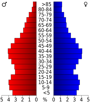
In 2000, the average age in the county was 36 years old. About 26.5% of the people were under 18 years old. This shows a mix of different age groups living in Rock County.
Communities
Rock County has many different towns and cities where people live.
Cities
- Beloit
- Brodhead (mostly in Green County)
- Edgerton (partly in Dane County)
- Evansville
- Janesville (County seat)
- Milton
Villages
Towns
These are larger areas that include smaller communities.
Census-designated places
These are areas that are like towns but are not officially incorporated as cities or villages.
Unincorporated communities
These are smaller communities that are not part of a city or village.
- Afton
- Anderson
- Avalon
- Avon
- Belcrest
- Bergen
- Cainville
- Center
- Charlie Bluff
- Cooksville
- Coopers Shores
- Crestview
- Emerald Grove
- Fairfield (partial)
- Foxhollow
- Indianford
- Johnstown
- Johnstown Center
- Koshkonong (partial)
- Leyden
- Lima Center
- Magnolia
- Mallwood
- Maple Beach
- Newark
- Newville
- Porters
- Stebbinsville
- Tiffany
- Union
- Victory Heights
Ghost towns/neighborhoods
These are places where people used to live, but now they are empty or abandoned.
Education
Many school districts serve the children of Rock County.
- Albany School District
- Beloit School District
- Beloit Turner School District
- Brodhead School District
- Clinton Community School District
- Delavan-Darien School District
- Edgerton School District
- Evansville Community School District
- Fort Atkinson School District
- Janesville School District
- Milton School District
- Oregon School District
- Parkview School District
- Stoughton Area School District
- Whitewater School District
There is also a special school for students with visual impairments. It is called the Wisconsin School for the Blind and Visually Impaired.
Tree cities
A "Tree City USA" is a town or city that meets certain standards for caring for its trees. Several communities in Rock County are recognized as Tree Cities:
- Beloit
- Clinton
- Edgerton
- Evansville
- Janesville
- Milton
See also
 In Spanish: Condado de Rock (Wisconsin) para niños
 | Delilah Pierce |
 | Gordon Parks |
 | Augusta Savage |
 | Charles Ethan Porter |


