
Brodhead, Wisconsin facts for kids
Quick facts for kids
Brodhead, Wisconsin
|
|
|---|---|

Location of Brodhead in Rock County, Wisconsin
|
|
| Country | |
| State | |
| Counties | Green, Rock |
| Area | |
| • Total | 1.79 sq mi (4.65 km2) |
| • Land | 1.79 sq mi (4.65 km2) |
| • Water | 0.00 sq mi (0.00 km2) |
| Elevation | 794 ft (242 m) |
| Population
(2020)
|
|
| • Total | 3,274 |
| • Density | 1,808.91/sq mi (698.49/km2) |
| Time zone | UTC-6 (Central (CST)) |
| • Summer (DST) | UTC-5 (CDT) |
| Zip Code |
53520
|
| Area code(s) | 608 |
| FIPS code | 55-09925 |
| GNIS feature ID | 1562229 |
Brodhead is a city located in both Green and Rock counties in the state of Wisconsin, United States. In 2020, about 3,274 people lived there. In 2000, the city grew by adding some land from the nearby Town of Spring Valley.
Contents
History of Brodhead
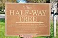
Just south of Brodhead, there's a special marker for the Half-Way Tree. This bur oak tree was once thought by Native Americans to be the middle point of a walking trail between Lake Michigan and the Mississippi River. Even though experts today say it's a bit off, the Half-Way Tree is still protected and stands as a historic landmark.
The railroad track that goes through Brodhead from east to west has a small museum next to a park. The museum has a train and an army tank on display. The railroad was very important for the town's beginning. In the spring of 1856, the railroad decided to create Brodhead as a halfway point between two other towns that wanted the railway.
The city was named after Edward Hallock Brodhead (1809–1890). He was the chief engineer of the Milwaukee and Mississippi Railroad and helped start the railway station here. The first streets in Brodhead were named after the people who owned the land. Later, these names were changed to numbers to make them easier to use.
Some other people who helped found the town were Edmund Deacon Clinton, Isaac Foster Mack, John P. Dixon, John Lucas Vischer Thomas, John L. McNair, Edmund Abbott West, and Erastus M. Smith.
Brodhead was also one of the first places to have electricity! A special canal was dug from a branch of the Sugar River to power a hydroelectric generator. This generator provided electricity to the town. This meant Brodhead had electricity even before some bigger cities like Chicago, and it might have been the very first place in Wisconsin to get it.
Brodhead's Geography
Brodhead is located at 42°37′7″N 89°22′35″W / 42.61861°N 89.37639°W.
The United States Census Bureau says that the city covers a total area of about 1.84 square miles (4.77 square kilometers). All of this area is land, with no water.
Climate in Brodhead
Brodhead has a hot-summer humid continental climate. This means it has warm, humid summers and cold winters. On climate maps, this type of weather is called "Dfa."
The hottest temperature ever recorded in Brodhead was 111°F (44°C). This happened on July 21, 1901, and again from July 12–14, 1936. The coldest temperature ever recorded was -36°F (-38°C) on January 30, 1951.
| Climate data for Brodhead, Wisconsin, 1991–2020 normals, extremes 1897–present | |||||||||||||
|---|---|---|---|---|---|---|---|---|---|---|---|---|---|
| Month | Jan | Feb | Mar | Apr | May | Jun | Jul | Aug | Sep | Oct | Nov | Dec | Year |
| Record high °F (°C) | 61 (16) |
71 (22) |
84 (29) |
92 (33) |
105 (41) |
109 (43) |
111 (44) |
103 (39) |
102 (39) |
89 (32) |
80 (27) |
69 (21) |
111 (44) |
| Mean maximum °F (°C) | 47.6 (8.7) |
52.4 (11.3) |
67.8 (19.9) |
79.4 (26.3) |
87.3 (30.7) |
92.3 (33.5) |
92.7 (33.7) |
91.6 (33.1) |
88.9 (31.6) |
82.1 (27.8) |
66.0 (18.9) |
51.8 (11.0) |
94.9 (34.9) |
| Mean daily maximum °F (°C) | 27.4 (−2.6) |
31.8 (−0.1) |
44.4 (6.9) |
58.3 (14.6) |
70.1 (21.2) |
79.8 (26.6) |
83.1 (28.4) |
81.3 (27.4) |
74.6 (23.7) |
61.6 (16.4) |
46.0 (7.8) |
32.8 (0.4) |
57.6 (14.2) |
| Daily mean °F (°C) | 19.0 (−7.2) |
22.7 (−5.2) |
34.5 (1.4) |
46.9 (8.3) |
58.6 (14.8) |
68.6 (20.3) |
72.0 (22.2) |
70.1 (21.2) |
62.4 (16.9) |
50.2 (10.1) |
36.9 (2.7) |
25.0 (−3.9) |
47.2 (8.5) |
| Mean daily minimum °F (°C) | 10.5 (−11.9) |
13.6 (−10.2) |
24.6 (−4.1) |
35.4 (1.9) |
47.1 (8.4) |
57.4 (14.1) |
61.0 (16.1) |
58.9 (14.9) |
50.1 (10.1) |
38.8 (3.8) |
27.8 (−2.3) |
17.2 (−8.2) |
36.9 (2.7) |
| Mean minimum °F (°C) | −11.8 (−24.3) |
−6.8 (−21.6) |
4.6 (−15.2) |
23.2 (−4.9) |
33.7 (0.9) |
44.8 (7.1) |
51.0 (10.6) |
49.2 (9.6) |
36.9 (2.7) |
25.5 (−3.6) |
12.2 (−11.0) |
−3.9 (−19.9) |
−16.1 (−26.7) |
| Record low °F (°C) | −36 (−38) |
−35 (−37) |
−21 (−29) |
7 (−14) |
24 (−4) |
33 (1) |
40 (4) |
35 (2) |
20 (−7) |
2 (−17) |
−18 (−28) |
−30 (−34) |
−36 (−38) |
| Average precipitation inches (mm) | 1.59 (40) |
1.75 (44) |
2.11 (54) |
3.73 (95) |
4.18 (106) |
5.56 (141) |
4.00 (102) |
4.35 (110) |
3.78 (96) |
2.94 (75) |
2.35 (60) |
1.96 (50) |
38.30 (973) |
| Average snowfall inches (cm) | 10.3 (26) |
9.3 (24) |
4.5 (11) |
0.9 (2.3) |
0.1 (0.25) |
0.0 (0.0) |
0.0 (0.0) |
0.0 (0.0) |
0.0 (0.0) |
0.3 (0.76) |
2.2 (5.6) |
9.7 (25) |
37.3 (94.91) |
| Average precipitation days (≥ 0.01 in) | 9.6 | 8.4 | 9.8 | 12.0 | 13.3 | 12.2 | 9.9 | 9.9 | 9.0 | 9.6 | 8.6 | 9.8 | 122.1 |
| Average snowy days (≥ 0.1 in) | 6.9 | 5.7 | 3.0 | 0.7 | 0.0 | 0.0 | 0.0 | 0.0 | 0.0 | 0.2 | 1.3 | 5.4 | 23.2 |
| Source 1: NOAA | |||||||||||||
| Source 2: National Weather Service | |||||||||||||
People in Brodhead (Demographics)
| Historical population | |||
|---|---|---|---|
| Census | Pop. | %± | |
| 1870 | 1,548 | — | |
| 1880 | 1,254 | −19.0% | |
| 1890 | 1,461 | 16.5% | |
| 1900 | 1,584 | 8.4% | |
| 1910 | 1,517 | −4.2% | |
| 1920 | 1,600 | 5.5% | |
| 1930 | 1,533 | −4.2% | |
| 1940 | 1,750 | 14.2% | |
| 1950 | 2,016 | 15.2% | |
| 1960 | 2,444 | 21.2% | |
| 1970 | 2,515 | 2.9% | |
| 1980 | 3,153 | 25.4% | |
| 1990 | 3,165 | 0.4% | |
| 2000 | 3,180 | 0.5% | |
| 2010 | 3,293 | 3.6% | |
| 2020 | 3,274 | −0.6% | |
| U.S. Decennial Census | |||
In 2010, there were 3,293 people living in Brodhead. These people lived in 1,346 households, and 851 of these were families. The city had about 1,790 people per square mile (691 people per square kilometer).
Most people in Brodhead were White (96.4%). A small number were African American (0.1%), Native American (0.3%), or Asian (0.5%). About 3.8% of the population identified as Hispanic or Latino.
About 32.3% of households had children under 18 living with them. Many households (46.8%) were married couples living together. The average household had 2.41 people, and the average family had 3.01 people.
The average age of people in Brodhead was 38.4 years. About 25% of residents were under 18 years old. About 17.6% were 65 years or older. There were slightly more females (52.7%) than males (47.3%) in the city.
Education in Brodhead
Students in Brodhead attend schools in the Brodhead School District. There are 1,039 students in total.
- Students from Pre-Kindergarten to 5th grade go to Albrecht Elementary School.
- Grades 6 through 8 attend Brodhead Middle School.
- Brodhead High School is the local high school, located at 2501 W 5th AVE, Brodhead, WI 53520.
The Brodhead school district has a good student-teacher ratio of 13 students for every teacher.
Transportation in Brodhead
Wisconsin State Highways
 WIS 11 goes right through the town as 1st Center Ave.
 WIS 81 runs south of the town.
 WIS 104 begins at the northeast part of the town.
Railroads
The Wisconsin and Southern Railroad has a branch line that runs through Brodhead on its way to Monroe.
Notable People from Brodhead
- Thax Douglas, a poet who lives in Brodhead.
- David Dunwiddie, a Wisconsin state legislator who lived in Brodhead.
- Milton S. Livingston, a physicist who was born in Brodhead.
- Harvey T. Moore, a Vermont and Wisconsin state legislator who lived in Brodhead.
- Henry Putnam, a Wisconsin state legislator who was President of Brodhead.
- Archibald N. Randall, a Wisconsin state legislator.
- Burr Sprague, a Wisconsin state legislator who lived in Brodhead.
- Albert M. Ten Eyck, an academic.
- Fred Ties, a Wisconsin state legislator who lived in Brodhead.
Gallery
-
-
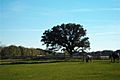
The Half-Way tree in Brodhead
-
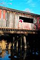
Covered bridge 1½ miles North of Brodhead on the Sugar River State Trail
-
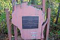
Covered bridge historic plate
-
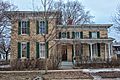
Francis West Smith House
-
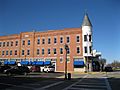
The Laube Building, part of the Exchange Square Historic District


See also
 In Spanish: Brodhead (Wisconsin) para niños
