
Dodge County, Wisconsin facts for kids
Quick facts for kids
Dodge County
|
|
|---|---|

Dodge County Administration building
|
|

Location within the U.S. state of Wisconsin
|
|
 Wisconsin's location within the U.S. |
|
| Country | |
| State | |
| Founded | 1844 |
| Named for | Henry Dodge |
| Seat | Juneau |
| Largest city | Beaver Dam |
| Area | |
| • Total | 907 sq mi (2,350 km2) |
| • Land | 876 sq mi (2,270 km2) |
| • Water | 31 sq mi (80 km2) 3.5% |
| Population
(2020)
|
|
| • Total | 89,396 |
| • Estimate
(2023)
|
88,231 |
| • Density | 102.1/sq mi (39.4/km2) |
| Time zone | UTC−6 (Central) |
| • Summer (DST) | UTC−5 (CDT) |
| Congressional districts | 5th, 6th |
Dodge County is a county located in the state of Wisconsin in the United States. It's a place where many people live and work. In 2020, about 89,396 people called Dodge County home. The main city, or county seat, where the local government offices are, is Juneau. This county was first created in 1836 and officially started operating in 1844.
Dodge County is part of a larger area that includes Beaver Dam. It's also connected to the bigger Milwaukee–Racine–Waukesha area, which is a group of cities and towns that are close to each other.
Contents
Geography: Where is Dodge County?
Dodge County covers a total area of about 907 square miles. Most of this area, about 876 square miles, is land. The rest, about 31 square miles, is water, which is about 3.5% of the county's total size.
You can find two large lakes here: Beaver Dam Lake, which is about 6,718 acres, and Fox Lake, which is about 2,713 acres. These lakes are great spots for outdoor activities!
Neighboring Counties
Dodge County shares its borders with several other counties. Think of them as its neighbors:
- Fond du Lac County to the northeast
- Washington County to the east
- Waukesha County to the southeast
- Jefferson County to the south
- Dane County to the southwest
- Columbia County to the west
- Green Lake County to the northwest
Protected Natural Areas
Part of the Horicon National Wildlife Refuge is located in Dodge County. This is a special area set aside to protect wildlife and their natural homes.
Population: Who Lives Here?
The number of people living in Dodge County has grown a lot over the years! In 1840, there were only 67 people. By 2020, the population had grown to 89,396. This means many more families and individuals have chosen to live here over time.


2020 Census Information
In 2020, the population was 89,396 people. The population density was about 102 people per square mile. This means that, on average, there were 102 people living in every square mile of land.
Most people in the county (88.8%) were White. Other groups included Black or African American (3.1%), Asian (0.6%), and Native American (0.5%). About 6.1% of the population was Hispanic or Latino.
Transportation: Getting Around
Dodge County has many ways for people to travel, whether by car, train, or plane.
Main Roads
Many important highways run through Dodge County, making it easy to connect to other parts of Wisconsin and beyond.
 Interstate 41
 U.S. Highway 41
 U.S. Highway 151
 Highway 16
 Highway 19
 Highway 26
 Highway 28
 Highway 33
 Highway 49
 Highway 60
 Highway 67
 Highway 68
 Highway 73
 Highway 89
 Highway 175
Railroads
Several train lines also pass through Dodge County, helping to move goods and sometimes people. These include:
- Amtrak
- Canadian National
- Canadian Pacific
- Union Pacific
- Wisconsin and Southern Railroad
Airport
For air travel, the Dodge County Airport (KUNU) serves the county and nearby towns.
Communities: Cities, Towns, and Villages
Dodge County is made up of many different communities, each with its own unique feel.
Cities
- Beaver Dam
- Columbus (mostly in Columbia County)
- Fox Lake
- Hartford (part; mostly in Washington County)
- Horicon
- Juneau (county seat)
- Mayville
- Watertown (mostly in Jefferson County)
- Waupun (partly in Fond du Lac County)
Villages
Towns
Census-Designated Places
These are areas that are like towns but are not officially incorporated as cities or villages.
Unincorporated Communities
These are smaller communities that are not officially part of a city or village.
- Alderley
- Astico
- Atwater
- Beaver Edge
- Clyman Junction
- Danville
- Delbern Acres
- East Waupun
- Farmersville
- Fox Lake Junction
- Herman Center
- Hochheim
- Huilsburg
- Knowles
- LeRoy
- Leipsig
- Lost Lake
- Lyndon Dale
- Minnesota Junction
- Nasbro
- Neda
- North Lowell
- Oak Grove
- Old Ashippun
- Old Lebanon
- Portland (partial)
- Richwood
- Rolling Prairie
- Rubicon
- Saylesville
- South Beaver Dam
- South Randolph
- Sugar Island
- Sunset Beach
- Theresa Station
- Woodland
Ghost Town
- Clason Prairie is a former community that no longer exists.
Gallery
-
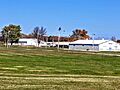
Dodge County Fairgrounds
-
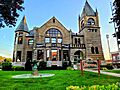
Dodge County Historical Society
-
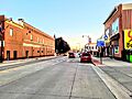
Downtown Beaver Dam, Wisconsin
-
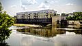
Watertown Riverwalk


See also
 In Spanish: Condado de Dodge (Wisconsin) para niños
