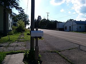
Alderley, Wisconsin facts for kids
Quick facts for kids
Alderley, Wisconsin
|
|
|---|---|

County Road O is the primary and sole modern-day thoroughfare for the small hamlet.
|
|
| Country | |
| State | |
| County | Dodge County |
| Town | Ashippun |
| Elevation | 290 m (951 ft) |
| Time zone | UTC-6 (Central (CST)) |
| • Summer (DST) | UTC-5 (CDT) |
| Area code(s) | 920 |
| GNIS feature ID | 1560746 |
Alderley is a small, unincorporated community located in Dodge County, Wisconsin, in the United States. An unincorporated community is a place that doesn't have its own local government. Instead, it is part of a larger area, like a town or county.
Alderley is found within the town of Ashippun. It sits about 7 miles (11 km) north of Stone Bank. It is also about 3 miles (5 km) north of Mapleton. The community is also 3 miles (5 km) east of the main Ashippun community.
Contents
Where is Alderley Located?
Alderley is situated in the southeastern part of Wisconsin. It is specifically in Dodge County. This county is known for its rich farming areas. The community's main road is Highway O. This road helps connect Alderley to nearby towns.
Geography of Alderley
The area around Alderley is mostly flat. It has many farms and open spaces. The elevation of Alderley is about 951 feet above sea level. This means it is not very high up. The land is good for growing crops.
The Name Alderley
The name "Alderley" has an interesting history. Early settlers came to this area from England. They decided to name their new home after a place they knew. This place was called Alderley Edge in England. It is a village and civil parish in Cheshire, England.
Why Communities are Named
Communities are often named for different reasons. Sometimes they are named after important people. Other times, they are named for local features. In Alderley's case, it was named to honor a place from the settlers' homeland. This shows a connection to their past.
 | Jackie Robinson |
 | Jack Johnson |
 | Althea Gibson |
 | Arthur Ashe |
 | Muhammad Ali |


