
Lomira, Wisconsin facts for kids
Quick facts for kids
Lomira, Wisconsin
|
|
|---|---|

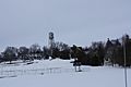
Downtown Lomira
|
|

Location of Lomira in Dodge County, Wisconsin.
|
|
| Country | |
| State | |
| County | Dodge |
| Area | |
| • Total | 2.15 sq mi (5.57 km2) |
| • Land | 2.14 sq mi (5.54 km2) |
| • Water | 0.01 sq mi (0.04 km2) |
| Elevation | 1,053 ft (321 m) |
| Population
(2020)
|
|
| • Total | 2,678 |
| • Density | 1,253.2/sq mi (483.8/km2) |
| Time zone | UTC-6 (Central (CST)) |
| • Summer (DST) | UTC-5 (CDT) |
| Area code(s) | 920 |
| FIPS code | 55-45500 |
| GNIS feature ID | 1568503 |
Lomira is a small village in Dodge County, Wisconsin, United States. In 2020, about 2,678 people lived there. The village is part of the Town of Lomira. It's easy to find because it sits at the intersection of several main roads: State Highways 49, 67, and 175, plus Interstate 41.
Contents
A Look Back: History of Lomira
The early story of Lomira village is connected to the wider Town of Lomira. Before white settlers arrived, it's believed that the son of Chief Black Hawk once camped nearby. He was blazing a trail from Milwaukee to Green Bay.
There are no records of a town in Lomira before 1849. It was first called Springfield. But in 1849, its name changed to Lomira. People say the village was named after Elmira Schoonover. She was the daughter of Sam Schoonover, one of the first settlers. The first Post Office opened on May 11, 1849.
Becoming an Official Village
On March 24, 1899, people asked the court to make Lomira an official village. The petition said that 433 people lived there. It also mentioned many businesses like stores, hotels, and a cheese factory. Lomira was also a train station.
Copies of the petition were put up in public places. On May 9, 1899, the court reviewed the request. A public vote was held on June 3, 1899. Out of 104 votes, 58 were for becoming a village, and 45 were against. So, Lomira officially became a village!
Where is Lomira? Geography
Lomira is located at coordinates 43°35′42″N 88°26′40″W / 43.59500°N 88.44444°W.
The United States Census Bureau says the village covers about 2.15 square miles (5.57 square kilometers). Most of this area is land, with only a tiny bit being water.
Many people in Lomira say it's in the middle of a "triangle." The three points of this triangle are Milwaukee, Green Bay, and Madison. Each of these bigger cities is about an hour's drive from Lomira.
Who Lives in Lomira? Demographics
| Historical population | |||
|---|---|---|---|
| Census | Pop. | %± | |
| 1900 | 492 | — | |
| 1910 | 529 | 7.5% | |
| 1920 | 554 | 4.7% | |
| 1930 | 603 | 8.8% | |
| 1940 | 659 | 9.3% | |
| 1950 | 746 | 13.2% | |
| 1960 | 807 | 8.2% | |
| 1970 | 1,084 | 34.3% | |
| 1980 | 1,446 | 33.4% | |
| 1990 | 1,542 | 6.6% | |
| 2000 | 2,233 | 44.8% | |
| 2010 | 2,430 | 8.8% | |
| 2020 | 2,678 | 10.2% | |
| U.S. Decennial Census | |||
In 2010, there were 2,430 people living in Lomira. The village had 1,002 households. About 95% of the people were White. A small number of people were African American, Native American, or Asian. About 4.6% of the population was Hispanic or Latino.
The average age of people in Lomira in 2010 was 36.7 years old. About 24.7% of residents were under 18.
Getting Around: Transportation
Lomira is a hub for travel because several major roads meet there. These include State Highways 49, 67, and 175. The important Interstate 41 also passes through.
The Canadian National Railroad offers train services for local businesses. If you need to fly, there are private airports in Fond du Lac, about 10 miles (16 km) north. For bigger commercial flights, you can go to airports in Appleton (50 miles/80 km north), Milwaukee (60 miles/97 km south), or Oshkosh (30 miles/48 km north).
Learning in Lomira: Education
The Lomira School District covers about 65 square miles (168 square kilometers). It includes Lomira village, plus nearby villages like Brownsville and Theresa. It also includes parts of several towns in Dodge, Fond du Lac, and Washington Counties.
The district has two elementary schools. One is in Lomira, part of a building that teaches students from kindergarten through 12th grade. The other elementary school is in Theresa. The high school in Lomira has about 355 students.
Lomira also has a private school called St. John's Lutheran School. Another Catholic school, Consolidated Catholic School Lomira-Theresa (CCLT), closed in 2010. In 2013, people in the district voted for big improvements to the schools. These plans included a new high school gym, new classrooms, and moving the football field.
What Lomira Does: Business and Industry
Lomira is in an area known for farming. Because of this, many local businesses are related to agriculture.
In 1985, printing became a major industry when Quad Graphics opened a large production plant. This plant is one of the biggest printing facilities in the Western Hemisphere! In 2007, Kondex Corporation, a company that makes farm machinery, opened a new factory in an industrial park.
Even though it's a small village, Lomira has many services. You can find 5 restaurants, 4 gas stations, 2 car dealerships, and several other businesses.
Places of Worship: Religion
| Church name | Denomination | Street address | Founding date |
|---|---|---|---|
| Nativity of St. Mary Parish | Catholic (Roman Rite) | 699 Milwaukee Street | 1870 |
| St. John's Lutheran Church & School | Lutheran (WELS) | 558 Water Street | 1863 |
| Trinity United Methodist Church | United Methodist | 300 Church Street | 1851 |
| Springfield Community Church | Non-Denominational | 412 Pleasant Hill Avenue | 2016 |
Famous Faces: Notable People
- Josh Bilicki, a NASCAR driver, is from Lomira.
Images for kids
-
Looking north at Lomira's skyline
-

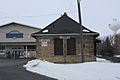
Post office
-
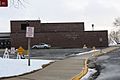
School
-
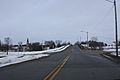
Looking east on Wisconsin Highway 67
-
Train depot
-
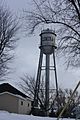
Water tower
-
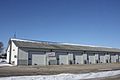
Public Works
-
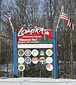
City welcome sign
-
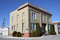
W. H. Boller Meat Market and Residence


See also
 In Spanish: Lomira (Wisconsin) para niños
