East Waupun, Wisconsin facts for kids
Quick facts for kids
East Waupun, Wisconsin
|
|
|---|---|

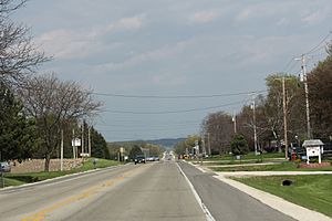
Looking east in East Waupun on Wisconsin Highway 49
|
|
| Country | |
| State | |
| County | Dodge County |
| Town | Chester |
| Elevation | 269 m (883 ft) |
| Time zone | UTC-6 (Central (CST)) |
| • Summer (DST) | UTC-5 (CDT) |
| Area code(s) | 920 |
| GNIS feature ID | 1577583 |
East Waupun is a small place in Wisconsin, United States. It's known as an unincorporated community. This means it's a group of homes and businesses that don't have their own local government like a city or a village does. Instead, it's part of a larger area called a town. East Waupun is located in the town of Chester.
Where is East Waupun?
East Waupun is found in Dodge County, Wisconsin. It's quite close to the city of Waupun, about 1 mile (2 kilometers) to its east. You can find it right along Wisconsin Highway 49, which is a road that connects different places in Wisconsin.
What is an Unincorporated Community?
An unincorporated community is a place where people live, but it's not officially a city or a town with its own mayor or town council. Instead, it's usually governed by the county or a larger local government, like the town of Chester in this case. People in these communities still get services like roads and police, but those services are managed by the bigger government.
Time Zone and Location Details
East Waupun is in the Central Time Zone. This means that during most of the year, its time is 6 hours behind UTC (the world's main time standard). When it's summer, they switch to Daylight Saving Time (CDT), which is 5 hours behind UTC. The area is also about 883 feet (269 meters) above sea level. This information helps us pinpoint exactly where East Waupun is on a map.
 | George Robert Carruthers |
 | Patricia Bath |
 | Jan Ernst Matzeliger |
 | Alexander Miles |


