
Fond du Lac County, Wisconsin facts for kids
Quick facts for kids
Fond du Lac County, Wisconsin
|
||
|---|---|---|

Fond du Lac County City/County Government Center.
|
||
|
||

Map of Wisconsin showing Fond du Lac County
|
||

Wisconsin's location in the contiguous United States
|
||
| Incorporated | 1839 | |
| Named for | French term meaning 'farthest end of the lake'. | |
| County seat | Fond du Lac | |
| Largest city | Fond du Lac | |
| Municipalities |
33 (total)
3 cities
21 towns 9 villages |
|
| Government | ||
| • Type | County | |
| • Body | Board of Supervisors | |
| Area | ||
| • Total | 1,980 km2 (766 sq mi) | |
| • Land | 1,900 km2 (720 sq mi) | |
| • Water | 120 km2 (46 sq mi) | |
| Area rank | 40th largest county in Wisconsin | |
| Population
(2020)
|
||
| • Total | 104,154 | |
| • Estimate
(2023)
|
103,948 |
|
| • Rank | 16th largest county in Wisconsin | |
| • Density | 55.9/km2 (144.7/sq mi) | |
| Time zone | UTC−6 (Central) | |
| • Summer (DST) | UTC−5 (Central) | |
| ZIP Code |
54971, 53931, 53919, 53946, 53963, 54964, 54932, 54974, 53065, 53006, 54979, 54937, 54935, 53048, 53010, 53040, 53011, 53019, 53057, 53079, 53049, 53061, 53014
|
|
| Area codes | 920 | |
| Congressional districts | 6th | |
| Interstates | ||
| U.S. Highways | ||
| State Routes | ||
| Airports | Fond du Lac County Airport
|
|
| Waterways | Fond du Lac River Milwaukee River Rock River Sheboygan River Lake Winnebago |
|
| Website | www.fdlco.wi.gov | |

Fond du Lac County is a county located in the state of Wisconsin, United States. In 2020, about 104,154 people lived here. The main city and county seat is Fond du Lac.
The county was created in 1836 when Wisconsin was still a territory. It was officially organized in 1844. The name "Fond du Lac" comes from French words meaning "bottom of the lake." This name was chosen because the county is located at the southern end of Lake Winnebago. Fond du Lac County is also part of a larger area called the Fond du Lac, Wisconsin Metropolitan Statistical Area. A special area known as The Holyland is found in the northeastern part of the county.
Contents
Exploring Fond du Lac County's Geography
Fond du Lac County covers a total area of about 766 square miles. Most of this area, 720 square miles, is land. The remaining 46 square miles (about 6%) is covered by water.
Neighboring Counties Around Fond du Lac
Fond du Lac County shares its borders with several other counties:
- Winnebago County to the north
- Calumet County to the northeast
- Sheboygan County to the east
- Washington County to the southeast
- Dodge County to the southwest
- Green Lake County to the west
Protected Natural Areas
Part of the Horicon National Wildlife Refuge is located within Fond du Lac County. This refuge helps protect wildlife and their habitats.
Travel and Transportation in Fond du Lac County
Getting around Fond du Lac County is easy thanks to its many roads and transportation options.
Main Highways and Routes
Many important roads pass through the county, connecting it to other parts of Wisconsin and beyond.
 Interstate 41
 U.S. Highway 41
 U.S. Highway 45
 U.S. Highway 151
 Highway 23 (Wisconsin)
 Highway 26 (Wisconsin)
 Highway 44 (Wisconsin)
 Highway 49 (Wisconsin)
 Highway 67 (Wisconsin)
 Highway 175 (Wisconsin)
Railroads Serving the County
Trains also play a role in transportation. The county is served by:
- Canadian National
- Wisconsin and Southern Railroad
Bus Services
For public transport, people can use:
- Fond du Lac Area Transit
- Intercity bus services
Local Airport
The Fond du Lac County Airport (FLD) helps connect the county by air. It serves the local community and nearby areas.
Understanding Fond du Lac County's Climate
|
||||||||||||||||||||||||||||||||||||||||||||||||||||||||||||||||||||||||||||||||||||||||||||||||
Fond du Lac County experiences a typical Midwestern climate. This means it has warm summers and cold, snowy winters. The climate chart above shows average temperatures and rainfall throughout the year.
Population and People of Fond du Lac County
| Historical population | |||
|---|---|---|---|
| Census | Pop. | %± | |
| 1840 | 139 | — | |
| 1850 | 14,510 | 10,338.8% | |
| 1860 | 34,154 | 135.4% | |
| 1870 | 46,273 | 35.5% | |
| 1880 | 46,859 | 1.3% | |
| 1890 | 44,088 | −5.9% | |
| 1900 | 47,589 | 7.9% | |
| 1910 | 51,610 | 8.4% | |
| 1920 | 56,119 | 8.7% | |
| 1930 | 59,883 | 6.7% | |
| 1940 | 62,353 | 4.1% | |
| 1950 | 67,829 | 8.8% | |
| 1960 | 75,085 | 10.7% | |
| 1970 | 84,567 | 12.6% | |
| 1980 | 88,964 | 5.2% | |
| 1990 | 90,083 | 1.3% | |
| 2000 | 97,296 | 8.0% | |
| 2010 | 101,633 | 4.5% | |
| 2020 | 104,154 | 2.5% | |
| U.S. Decennial Census 1790–1960 1900–1990 1990–2000 2010–2020 |
|||
The population of Fond du Lac County has grown a lot over the years. In 1840, only 139 people lived here. By 2020, the population had grown to 104,154 people.
Population Details from the 2020 Census
In 2020, the county had a population of 104,154. There were about 144.7 people living per square mile. The county had 45,740 housing units.
The people living in Fond du Lac County come from many different backgrounds:
- 88.0% were White.
- 2.3% were Black or African American.
- 1.2% were Asian.
- 0.5% were Native American.
- 3.0% were from other races.
- 5.0% were from two or more races.
About 6.4% of the population identified as Hispanic or Latino.
Cities, Towns, and Villages in Fond du Lac County
Fond du Lac County is made up of many different communities. These include cities, villages, and towns.


Cities in the County
- Fond du Lac (This is the main city and the county seat)
- Ripon
- Waupun (Most of this city is in Dodge County)
Villages in the County
- Brandon
- Campbellsport
- Eden
- Fairwater
- Kewaskum (Most of this village is in Washington County)
- Mount Calvary
- North Fond du Lac
- Oakfield
- Rosendale
- St. Cloud
Towns in the County
Census-Designated Places (CDPs)
These are areas that are like towns but are not officially incorporated as cities or villages.
Unincorporated Communities
These are smaller communities that are not part of any city, village, or town government.

- Alto
- Arcade Acres
- Armstrong
- Artesia Beach
- Ashford
- Banner
- Bergen Beach
- Byron
- Calumet Harbor
- Calumetville
- Calvary
- Chinatown
- Dexter
- Dotyville
- Dundee
- Eldorado
- Elmore
- Garnet
- Gladstone Beach
- Graham Corners
- Hamilton
- Highland Park
- Hopokoekau Beach
- Johnsburg
- Ladoga
- Laudolff Beach
- Luco
- Malone
- Marblehead
- Marytown
- Metomen
- Minawa Beach
- New Fane
- New Prospect
- Oak Center
- Peebles
- Pipe
- Pukwana Beach
- Rogersville
- Rosendale Center
- St. Joe
- Silica
- South Byron
- Waucousta
- Welling Beach
- West Rosendale
- Wilmoore Heights
- Winnebago Heights
- Winnebago Park
- Woodhull
High Schools in Fond du Lac County
Students in Fond du Lac County attend several public high schools:
- Campbellsport High School
- Fond Du Lac High School
- Horace Mann High School
- Ripon High School
Images for kids
-
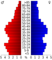
This chart shows the age groups of people in Fond du Lac County from the 2000 Census.

See also
 In Spanish: Condado de Fond du Lac para niños
