
Winnebago County, Wisconsin facts for kids
Quick facts for kids
Winnebago County
|
|
|---|---|

Winnebago County Courthouse
|
|

Location within the U.S. state of Wisconsin
|
|
 Wisconsin's location within the U.S. |
|
| Country | |
| State | |
| Founded | 1848 |
| Named for | Winnebago people |
| Seat | Oshkosh |
| Largest city | Oshkosh |
| Area | |
| • Total | 579 sq mi (1,500 km2) |
| • Land | 434 sq mi (1,120 km2) |
| • Water | 144 sq mi (370 km2) 25%% |
| Population
(2020)
|
|
| • Total | 171,730 |
| • Estimate
(2023)
|
171,735 |
| • Density | 395.1/sq mi (152.5/km2) |
| Time zone | UTC−6 (Central) |
| • Summer (DST) | UTC−5 (CDT) |
| Congressional districts | 6th, 8th |
Winnebago County is a county in the state of Wisconsin in the United States. In 2020, about 171,730 people lived here. The main city and government center is Oshkosh.
The county is named after the Winnebago people. They are a Native American tribe. Today, they are known as the Ho-Chunk Nation. Chief Oshkosh was an important Menominee leader in this area. The Oshkosh and Neenah areas are part of a larger group of cities called the Fox Cities.
Contents
History of Winnebago County
Long ago, several Native American tribes lived in this area. These included the Sauk, Fox, Menominee, and Ojibwa tribes. French traders and missionaries came here first. They wanted to trade and share their religion.
Later, European and American settlers moved into the area. This pushed the Native American tribes from their traditional lands. In the mid-1800s, the United States government made agreements with the tribes. These agreements often moved the tribes further west.
Winnebago County was officially created in 1840. It started its government in 1848. The name Winnebago comes from an Algonquin word. It means 'people dwelling by the muddy or smelly water'. This might refer to the Fox River or a sulfur spring.
Oshkosh, the county's main city, became a city in 1853. It already had almost 2,800 people living there. The city was named after Chief Oshkosh. He was a Menominee leader. He helped 2,500 of his people stay in Wisconsin. This was at a time when the government wanted to move all Native Americans west.
Geography of Winnebago County
Winnebago County covers about 579 square miles. About 434 square miles are land. The other 144 square miles (25%) are water.
Neighboring Counties
Winnebago County shares borders with these counties:
- Waupaca County (northwest)
- Outagamie County (northeast)
- Calumet County (east)
- Fond du Lac County (south)
- Green Lake County (southwest)
- Waushara County (west)
Main Roads
Many important roads run through Winnebago County:
 Interstate 41
 U.S. Highway 10
 U.S. Highway 41
 U.S. Highway 45
 Wisconsin Highway 21
 Wisconsin Highway 26
 Wisconsin Highway 44
 Wisconsin Highway 47
 Wisconsin Highway 76
 Wisconsin Highway 91
 Wisconsin Highway 114
 Wisconsin Highway 116
 Wisconsin Highway 441
Trains and Buses
- Trains: Canadian National and Wisconsin and Southern Railroad operate here.
- Buses: GO Transit (Wisconsin) and Valley Transit (Wisconsin) provide bus services.
Airports
Wittman Regional Airport (KOSH) serves the county. It is used for general aviation. Brennand Airport (79C) is a popular spot for recreational planes. For bigger flights, people use Appleton International Airport. It is in the nearby Outagamie County.
Population Information
| Historical population | |||
|---|---|---|---|
| Census | Pop. | %± | |
| 1840 | 135 | — | |
| 1850 | 10,167 | 7,431.1% | |
| 1860 | 23,770 | 133.8% | |
| 1870 | 37,279 | 56.8% | |
| 1880 | 42,740 | 14.6% | |
| 1890 | 50,097 | 17.2% | |
| 1900 | 58,225 | 16.2% | |
| 1910 | 62,116 | 6.7% | |
| 1920 | 63,897 | 2.9% | |
| 1930 | 76,622 | 19.9% | |
| 1940 | 80,507 | 5.1% | |
| 1950 | 91,103 | 13.2% | |
| 1960 | 107,928 | 18.5% | |
| 1970 | 129,931 | 20.4% | |
| 1980 | 131,703 | 1.4% | |
| 1990 | 140,320 | 6.5% | |
| 2000 | 156,763 | 11.7% | |
| 2010 | 166,994 | 6.5% | |
| 2020 | 171,730 | 2.8% | |
| U.S. Decennial Census 1790–1960 1900–1990 1990–2000 2010–2020 |
|||
In 2020, the population of Winnebago County was 171,730 people. Most people (86.2%) were White. Other groups included Asian (3.3%), Black or African American (3.0%), and Native American (0.7%). About 4.8% of the population was Hispanic or Latino.
Cities and Towns
Winnebago County has several cities, villages, and towns.
Cities
- Appleton (mostly in other counties)
- Menasha (partly in another county)
- Neenah
- Omro
- Oshkosh (the county seat)
Villages
Towns
Census-Designated Places
These are special areas that are like towns but not officially incorporated:
Unincorporated Communities
These are smaller communities that are not part of a city or village:
- Adella Beach
- Allenville
- Black Wolf
- Black Wolf Point
- Clarks Point
- Decorah Beach
- Elo
- Fairview Beach
- Fisk
- Fitzgerald
- Harbor Springs
- Highland Shore
- Indian Shores
- Island Park
- Larsen
- Lasleys Point
- Leonards Point
- Little Point
- Koro
- Medina Junction
- Melrose Park
- Metz (partial)
- Mikesville
- Nichols Shore Acres
- Oakwood
- Orihula
- Paukotuk
- Piacenza
- Pickett
- Plummer Point
- Point Comfort
- Reighmoor
- Ricker Bay
- Ring
- Rivermoor
- Rush Lake
- Shangri La Point
- Snells
- Sunrise Bay
- Waverly Beach (partial)
- Winnebago
- Zion
- Zittau
Former Communities
Images for kids
-
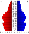
This chart shows the age groups of people in Winnebago County from the 2000 Census.

See also
 In Spanish: Condado de Winnebago (Wisconsin) para niños
