Waushara County, Wisconsin facts for kids
Quick facts for kids
Waushara County
|
|
|---|---|

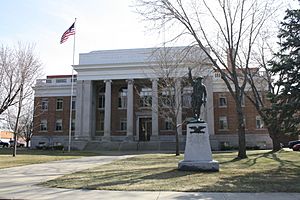
Waushara County Courthouse
|
|

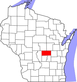
Location within the U.S. state of Wisconsin
|
|
 Wisconsin's location within the U.S. |
|
| Country | |
| State | |
| Founded | 1852 |
| Named for | Ho-Chunk term meaning "good earth" |
| Seat | Wautoma |
| Largest city | Berlin |
| Area | |
| • Total | 637 sq mi (1,650 km2) |
| • Land | 626 sq mi (1,620 km2) |
| • Water | 11 sq mi (30 km2) 1.8%% |
| Population
(2020)
|
|
| • Total | 24,520 |
| • Estimate
(2023)
|
24,934 |
| • Density | 39.2/sq mi (15.1/km2) |
| Time zone | UTC−6 (Central) |
| • Summer (DST) | UTC−5 (CDT) |
| Congressional district | 6th |
Waushara County is a special area called a county in the state of Wisconsin, USA. In 2020, about 24,520 people lived here. The main town, or county seat, where the county government is located, is Wautoma.
Waushara County is in the middle of Wisconsin. It is about 80 miles (129 km) north of Madison, the state capital.
Contents
History of Waushara County
Waushara County was officially created on February 15, 1851. At first, it had only one organized area called the Town of Waushara. In 1852, the county became fully organized and ready to operate.
The first county seat was in a place called Sacramento. But in 1854, after a big disagreement, the county seat was moved to Wautoma. The name "Waushara" comes from the Ho-Chunk people. It is thought to mean "good land."
Geography and Landscape
Waushara County covers a total area of 637 square miles (1,650 km²). Most of this area, 626 square miles (1,621 km²), is land. The remaining 11 square miles (28 km²), which is about 1.8%, is water.
Main Roads in Waushara County
These are the most important roads that help people travel through Waushara County:
 Interstate 39
 U.S. Highway 51
 Highway 21 (Wisconsin)
 Highway 22 (Wisconsin)
 Highway 49 (Wisconsin)
 Highway 73 (Wisconsin)
 Highway 152 (Wisconsin)
Airports Serving Waushara County
Two airports serve Waushara County and nearby towns:
- Wautoma Municipal Airport (Y50)
- Wild Rose Idlewild Airport (W23)
Neighboring Counties
Waushara County shares borders with these other counties:
- Portage County to the north
- Waupaca County to the northeast
- Winnebago County to the east
- Green Lake County to the south
- Marquette County to the south
- Adams County to the west
Climate in Waushara County
|
||||||||||||||||||||||||||||||||||||||||||||||||||||||||||||||||||||||||||||||||||||||||||||||||
Population and People
| Historical population | |||
|---|---|---|---|
| Census | Pop. | %± | |
| 1860 | 8,770 | — | |
| 1870 | 11,279 | 28.6% | |
| 1880 | 12,687 | 12.5% | |
| 1890 | 13,507 | 6.5% | |
| 1900 | 15,972 | 18.2% | |
| 1910 | 18,886 | 18.2% | |
| 1920 | 16,712 | −11.5% | |
| 1930 | 14,427 | −13.7% | |
| 1940 | 14,268 | −1.1% | |
| 1950 | 13,920 | −2.4% | |
| 1960 | 13,497 | −3.0% | |
| 1970 | 14,795 | 9.6% | |
| 1980 | 18,526 | 25.2% | |
| 1990 | 19,385 | 4.6% | |
| 2000 | 23,154 | 19.4% | |
| 2010 | 24,496 | 5.8% | |
| 2020 | 24,520 | 0.1% | |
| U.S. Decennial Census 1790–1960 1900–1990 1990–2000 2010 2020 |
|||
2020 Census Information
In 2020, the population of Waushara County was 24,520 people. This means there were about 39.2 people living in each square mile (15.1 people per km²). There were also 14,710 homes, with about 23.5 homes per square mile (9.1 homes per km²).
Most people in the county, about 89.9%, were White. Other groups included 1.6% Black or African American, 0.6% Native American, and 0.4% Asian. About 2.8% of people were from other races, and 4.6% identified with two or more races. When looking at ethnicity, 6.9% of the population was Hispanic or Latino.
Communities in Waushara County
Waushara County has several different types of communities:
Cities
- Berlin (most of this city is in Green Lake County)
- Wautoma (This is the county seat, where the main government offices are.)
Villages
Towns
Census-Designated Places
These are areas that are like towns but are not officially incorporated as cities or villages:
Unincorporated Communities
These are smaller communities that are not part of any city or village government:
- Auroraville
- Bannerman
- Borth
- Brushville
- Dakota
- Fountain Valley
- Heffron (partially)
- Metz (partial)
- Mount Morris
- Richford
- Saxeville
- Silver Lake
- Spring Lake
- West Bloomfield
Ghost Towns
See also
 In Spanish: Condado de Waushara para niños
 | Audre Lorde |
 | John Berry Meachum |
 | Ferdinand Lee Barnett |


