Adams County, Wisconsin facts for kids
Quick facts for kids
Adams County
|
|
|---|---|
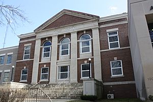
Adams County Courthouse
|
|
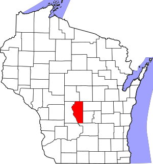
Location within the U.S. state of Wisconsin
|
|
 Wisconsin's location within the U.S. |
|
| Country | |
| State | |
| Founded | 1853 |
| Named for | John Adams or John Quincy Adams |
| Seat | Friendship (village) |
| Largest city | Adams |
| Area | |
| • Total | 689 sq mi (1,780 km2) |
| • Land | 646 sq mi (1,670 km2) |
| • Water | 43 sq mi (110 km2) 6.2% |
| Population
(2020)
|
|
| • Total | 20,654 |
| • Estimate
(2023)
|
21,449 |
| • Density | 32.0/sq mi (12.4/km2) |
| Time zone | UTC−6 (Central) |
| • Summer (DST) | UTC−5 (CDT) |
| Congressional district | 3rd |
Adams County is a county located in the state of Wisconsin, United States. In 2020, about 20,654 people lived here. The main town and county seat is Friendship.
Adams County was officially created in 1848 and started its government in 1853. People aren't sure if it was named after John Adams, who was the second U.S. President, or his son, John Quincy Adams, who was the sixth President.
History of Adams County
The first settlers in Adams County came from upstate New York. These families were often called "Yankee" settlers. They were descendants of English people who settled in New England in the 1600s.
These settlers were part of a big move west in the early 1800s. They traveled to what was then the wild Northwest Territory. Many arrived after the Erie Canal was finished and the Black Hawk War ended. They reached Adams County by sailing up the Wisconsin River from the Mississippi River. They built small boats from wood they found nearby.
When they arrived, the area was a thick forest. The "Yankee" settlers cleared land for farms and built roads. They also set up government buildings and postal routes. They brought their New England values with them. This included a strong belief in education, so they built many schools. They also strongly supported ending slavery. Most were members of the Congregationalist Church. Some had become Methodists or Baptists before moving. For a long time, Adams County's culture was very similar to early New England.
In the late 1880s, people from Germany started moving to Adams County. Before this time, very few German settlers lived there. Generally, the German and "Yankee" settlers got along well. However, they sometimes disagreed on certain issues.
One disagreement was about banning alcohol. The "Yankees" were split on this, but almost all Germans were against banning it. This helped stop alcohol from being banned. Later, they also had different views on World War I. The "Yankees" were generally supportive of Britain. However, many of them did not want America to join the war. The Germans felt sympathy for Germany and did not want the U.S. to fight against it. But the Germans were not against Britain. Before the war, many German leaders in Wisconsin praised America. They liked that America had English laws and political ideas. They felt this was better than the problems they had left behind in Germany.
How Adams County Got Its Shape
The land that is now Adams County was once part of other counties. In 1840, it was the southwestern part of Brown County. In 1836, Portage County was created. This included much of what is now Columbia County. In 1846, Portage County was renamed Columbia County. A new Portage County was then created to the north.
In 1848, the southern part of this new Portage County became Adams County. It included all of today's Adams County and the northern part of Juneau County. Adams County officially started its government in April 1853. In 1858, the northwestern part of Adams County joined with part of Sauk County to form Juneau County. At this point, Adams County got its current shape.
The Story of Adams and Friendship
The village of Friendship was founded by settlers from a town called Friendship, New York. Today, Adams is the biggest community in Adams County. But this wasn't always the case.
In the 1880s, a railroad was planned to connect Chicago and St. Paul. It was supposed to go through Friendship. But local landowners in Friendship asked for too much money for their land. So, the railroad decided to build the tracks about 2 miles (3 km) south of Friendship instead. One local resident, Emma Barnes, wrote in 1957 that she thought the people of Friendship should be thankful. She believed that by asking for high prices, they saved their beautiful village from the noise and smoke of a train.
To house the railroad workers, boxcars were stacked up to create homes. This is how the town of Adams was started. The railroad first called this new town "Friendship." However, there were two "Friendship" train stops on the same line. This confused passengers, who often bought the wrong tickets. So, the name had to be changed. The citizens chose between "Adams," named after President John Adams, and "Nottingham." They picked Adams. This railroad line became known as the famous "400" route. Today, Adams has about three times as many people as Friendship.
Geography
According to the U.S. Census Bureau, Adams County covers a total area of 689 square miles. About 646 square miles of this is land, and 43 square miles (6.2%) is water.
Major Highways
 Highway 13 (Wisconsin)
 Highway 21 (Wisconsin)
 Highway 23 (Wisconsin)
 Highway 73 (Wisconsin)
 Highway 82 (Wisconsin)
Railroads
Airport
- 63C - Adams County Airport serves the county and nearby towns.
Neighboring Counties
- Wood County – to the northwest
- Portage County – to the northeast
- Waushara County – to the east
- Marquette County – to the east
- Columbia County – to the southeast
- Sauk County – to the southwest
- Juneau County – to the west
Population Information
| Historical population | |||
|---|---|---|---|
| Census | Pop. | %± | |
| 1850 | 187 | — | |
| 1860 | 6,492 | 3,371.7% | |
| 1870 | 6,601 | 1.7% | |
| 1880 | 6,741 | 2.1% | |
| 1890 | 6,889 | 2.2% | |
| 1900 | 9,141 | 32.7% | |
| 1910 | 8,604 | −5.9% | |
| 1920 | 9,287 | 7.9% | |
| 1930 | 8,003 | −13.8% | |
| 1940 | 8,449 | 5.6% | |
| 1950 | 7,906 | −6.4% | |
| 1960 | 7,566 | −4.3% | |
| 1970 | 9,234 | 22.0% | |
| 1980 | 13,457 | 45.7% | |
| 1990 | 15,682 | 16.5% | |
| 2000 | 18,643 | 18.9% | |
| 2010 | 20,875 | 12.0% | |
| 2020 | 20,654 | −1.1% | |
| U.S. Decennial Census 1790–1960 1900–1990 1990–2000 2010–2020 |
|||
2020 Census Details
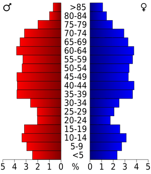
In 2020, the population of Adams County was 20,654 people. There were about 32 people per square mile. The county had 16,692 housing units.
Most residents, about 90.7%, were White. About 2.9% were Black or African American. Around 1.0% were Native American, and 0.4% were Asian. About 1.1% were from other backgrounds, and 3.9% were from two or more backgrounds. About 3.9% of the population identified as Hispanic or Latino.
Communities
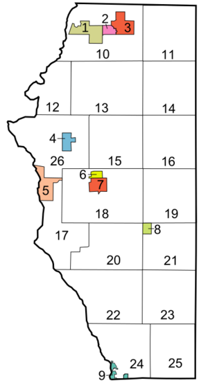
The number in brackets refers to the location on the map to the right.
Cities
- Adams (7)
- Wisconsin Dells (this city is also in Columbia County, Juneau County, and Sauk County) (9)
Village
- Friendship (6) (This is the county seat)
Towns
Census-Designated Places
These are areas that are like towns but are not officially incorporated.
- Arkdale (4)
- Dellwood (5)
- Grand Marsh (8)
- Lake Arrowhead (1)
- Lake Camelot (3)
- Lake Sherwood (2)
Unincorporated Communities
These are small communities that are not officially part of a city or village.
Ghost Towns/Neighborhoods
These are places that used to be communities but are no longer populated.
See also
 In Spanish: Condado de Adams (Wisconsin) para niños
 | Emma Amos |
 | Edward Mitchell Bannister |
 | Larry D. Alexander |
 | Ernie Barnes |


