
Calumet County, Wisconsin facts for kids
Quick facts for kids
Calumet County
|
||
|---|---|---|

Calumet County Courthouse
|
||
|
||

Location within the U.S. state of Wisconsin
|
||
 Wisconsin's location within the U.S. |
||
| Country | ||
| State | ||
| Founded | 1850 | |
| Seat | Chilton | |
| Largest city | Chilton | |
| Area | ||
| • Total | 397 sq mi (1,030 km2) | |
| • Land | 318 sq mi (820 km2) | |
| • Water | 79 sq mi (200 km2) 20% | |
| Population
(2020)
|
||
| • Total | 52,442 | |
| • Estimate
(2023)
|
53,199 |
|
| • Density | 164.8/sq mi (63.6/km2) | |
| Time zone | UTC−6 (Central) | |
| • Summer (DST) | UTC−5 (CDT) | |
| Congressional district | 8th | |


Calumet County is a county in the state of Wisconsin, USA. It is home to over 52,000 people. The main city and county seat is Chilton. The county was officially formed in 1850.
Calumet County is part of a larger area that includes the cities of Appleton, Oshkosh, and Neenah. A special area called The Holyland is also partly located here.
Contents
Discovering Calumet County's Past
The name "Calumet" comes from a French word. It means a special ceremonial pipe used by Native Americans. They used these pipes during important meetings on the east side of Lake Winnebago.
Early Native American Settlements
In the 1830s, the U.S. government moved several Native American groups to this area. These included the Brothertown Indians, Oneida Indians, and Stockbridge-Munsee Indians. They came from New York and New England. These groups had already moved once before. They shared land on the Oneida reservation.
European Settlers Arrive
Many of the first European settlers came from Germany in the 1840s. They settled in the southern part of the county, known as the Holyland region. The county was officially set up on February 5, 1850.
Exploring Calumet County's Geography
Calumet County covers about 397 square miles. About 318 square miles are land, and 79 square miles are water. This means about 20% of the county is water. It is one of the smallest counties in Wisconsin.
The western border of the county is mostly in Lake Winnebago. The Niagara Escarpment is a long ridge of rock that runs through the county. It was shaped by huge sheets of ice called glaciers long ago.
Neighboring Counties
Calumet County shares its borders with several other counties:
- Brown County to the northeast
- Manitowoc County to the east
- Sheboygan County to the southeast
- Fond du Lac County to the southwest
- Winnebago County to the west
- Outagamie County to the northwest
Calumet County's Climate
|
||||||||||||||||||||||||||||||||||||||||||||||||||||||||||||||||||||||||||||||||||||||||||||||||
People of Calumet County
| Historical population | |||
|---|---|---|---|
| Census | Pop. | %± | |
| 1840 | 275 | — | |
| 1850 | 1,743 | 533.8% | |
| 1860 | 1,895 | 8.7% | |
| 1870 | 12,335 | 550.9% | |
| 1880 | 16,632 | 34.8% | |
| 1890 | 16,639 | 0.0% | |
| 1900 | 17,078 | 2.6% | |
| 1910 | 16,701 | −2.2% | |
| 1920 | 17,228 | 3.2% | |
| 1930 | 16,848 | −2.2% | |
| 1940 | 17,618 | 4.6% | |
| 1950 | 18,840 | 6.9% | |
| 1960 | 22,268 | 18.2% | |
| 1970 | 27,604 | 24.0% | |
| 1980 | 30,867 | 11.8% | |
| 1990 | 34,291 | 11.1% | |
| 2000 | 40,631 | 18.5% | |
| 2010 | 48,971 | 20.5% | |
| 2020 | 52,442 | 7.1% | |
| U.S. Decennial Census 1790–1960 1900–1990 1990–2000 2010–2020 |
|||
Population in 2020
In 2020, Calumet County had 52,442 residents. This means there were about 165 people living in each square mile. Most people living here are White (88.7%). There are also people of Asian (2.4%), Black (0.8%), and Native American (0.5%) backgrounds. About 5.4% of the population is Hispanic or Latino.
Calumet County's Economy
Calumet County is a very important place for farming, especially for dairy. There are more cows and calves than people in the county!
Farming and Dairy Industry
As of 2010, there were 28,600 dairy cows and 65,000 total cattle. Farmers own about 73% of the land in the county. Around 2,400 people work in farming. Agriculture brings in a lot of money for the county, about $338 million in economic activity. Most farms (99.3%) are owned by families.
In 1931, the state of Wisconsin said Calumet County was one of the most important places for making American cheese.
Getting Around Calumet County
Main Roads
 U.S. Highway 10
 U.S. Highway 151
 Highway 32 (Wisconsin)
 Highway 55 (Wisconsin)
 Highway 57 (Wisconsin)
 Highway 114 (Wisconsin)
 Highway 441 (Wisconsin)
No major interstate highways run through Calumet County. However, several U.S. routes cross the area. U.S. Route 10 goes east to west across the northern part. U.S. Route 151 runs north to south. State highways like 55, 32, and 57 also help people travel.
Trains and Buses
- Wisconsin and Southern Railroad
- Canadian National
- Valley Transit (Wisconsin) buses also serve the area.
Airport and Waterways
The New Holstein Municipal Airport helps people travel by air. It is near New Holstein.
Lake Winnebago forms most of the county's western border. Early explorers likely used the lake and the Fox River to enter the area. The Manitowoc River and Sheboygan River also flow through the county. They eventually reach Lake Michigan.
Fun Things to Do in Calumet County
County Parks and Fairgrounds
Calumet County has three county parks. It also has two harbors managed by the county.
The Calumet County Fairgrounds hosts the annual county fair. In 2006, they celebrated their 150th fair! The fairgrounds also used to have exciting dirt track stock car races on summer Friday nights.
Enjoying Lake Winnebago
Lake Winnebago is a big part of life in Calumet County. People love to go boating and fishing on the lake in summer. In winter, it becomes a popular spot for ice fishing. The Wisconsin Department of Natural Resources even manages a special sturgeon spearing season in February.
Communities in Calumet County
Cities
- Appleton (mostly in other counties)
- Brillion
- Chilton (county seat)
- Kaukauna (mostly in other counties)
- Kiel (mostly in other counties)
- Menasha (mostly in other counties)
- New Holstein
Villages
- Harrison (partially in another county)
- Hilbert
- Potter
- Sherwood
- Stockbridge
Towns
Other Communities
- Forest Junction (a census-designated place)
Small Communities and Hamlets
- Brant
- Brothertown
- Calumetville (partial)
- Charlesburg
- Dundas
- Eckers Lakeland
- Hayton
- Highland Beach
- Jericho
- Kloten
- Maple Heights
- Meggers (partial)
- Quinney
- Rockaway Beach
- Saint Catherines Bay
- St. Anna (partial)
- St. John
- Utowana Beach
- Waverly Beach (partial)
- Wells (partial)
Old or Lost Towns
Images for kids
-
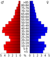
Age pyramid for Calumet County
-

The Calumet County Fair at night in 2006
-
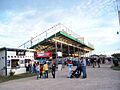
Grandstands at the 2006 Calumet County Fair
-
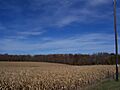
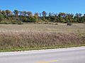
Rolling fields and woods in Calumet County during autumn
-
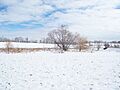
A snowy scene in Calumet County during winter
-
The Niagara Escarpment in Calumet County
-
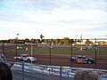
Stock cars at the county fairgrounds
-
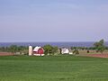
Farmland overlooking Lake Winnebago


See also
 In Spanish: Condado de Calumet para niños
