Sheboygan County, Wisconsin facts for kids
Quick facts for kids
Sheboygan County, Wisconsin
|
|||
|---|---|---|---|
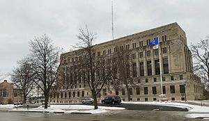
Sheboygan County Courthouse
|
|||
|
|||
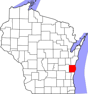
Map of Wisconsin showing Sheboygan County
|
|||
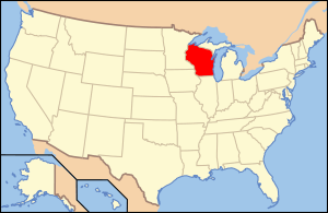
Wisconsin's location in the contiguous United States
|
|||
| Country | |||
| State | |||
| Incorporated | 1846 | ||
| Named for | Sheboygan River | ||
| County seat | Sheboygan | ||
| Largest city | Sheboygan | ||
| Incorporated municipalities |
28 (total)
3 cities
19 towns 11 villages |
||
| Government | |||
| • Type | County | ||
| • Body | Board of Supervisors | ||
| Area | |||
| • Total | 1,271 sq mi (3,290 km2) | ||
| • Land | 511 sq mi (1,320 km2) | ||
| • Water | 760 sq mi (2,000 km2) | ||
| Area rank | 56th largest county in Wisconsin | ||
| Population
(2020)
|
|||
| • Total | 118,034 | ||
| • Estimate
(2023)
|
117,752 |
||
| • Rank | 13th largest county in Wisconsin | ||
| • Density | 92.87/sq mi (35.856/km2) | ||
| Time zone | UTC−6 (Central) | ||
| • Summer (DST) | UTC−5 (Central) | ||
| ZIP Code |
53081, 53083, 53073, 53085, 53070, 53044, 53093, 53001, 53031, 53026, 53082
|
||
| Area codes | 920 | ||
| Congressional districts | 6th | ||
| Interstates | |||
| State Routes | |||
| Airports | Sheboygan County Memorial Airport
|
||
| Waterways | Lake Michigan – Sheboygan River – North Branch Milwaukee River
|
||
| Public transit | Shoreline Metro | ||
Sheboygan County (say it: shih-BOY-gun) is a county in the state of Wisconsin, USA. It gets its name from the Sheboygan River. In 2020, about 118,034 people lived here. The main city and county center is Sheboygan.
The county was first set up in 1836 and officially started in 1846. Back then, it was part of the Wisconsin Territory. Sheboygan County is also part of a larger area called the Sheboygan, WI Metropolitan Statistical Area. A small part of a special area known as the Holyland is in the northwestern part of the county.
Contents
Exploring Sheboygan County: Geography
Sheboygan County covers a total area of about 1,271 square miles. Most of this area, about 760 square miles (60%), is water, mainly from Lake Michigan. The land area is around 511 square miles.
Getting Around: Major Roads
You can travel through Sheboygan County using several important highways:
- Interstate 43
- Highway 23 (Wisconsin)
- Highway 28 (Wisconsin)
- Highway 32 (Wisconsin)
- Highway 42 (Wisconsin)
- Highway 57 (Wisconsin)
- Highway 67 (Wisconsin)
- Highway 144 (Wisconsin)
Trains and Railways
Two main train lines run through the county:
- Union Pacific
- Wisconsin and Southern Railroad
Public Transport: Buses
If you need to get around without a car, Shoreline Metro provides bus services in the area.
Flying In: The Airport
The Sheboygan County Memorial Airport (KSBM) serves the county and nearby towns. It's where smaller planes can land and take off.
Neighboring Counties
Sheboygan County shares its borders with these other counties:
- Manitowoc County to the north
- Ozaukee County to the south
- Washington County to the southwest
- Fond du Lac County to the west
- Calumet County to the northwest
Underwater Wonders: Shipwreck Sanctuary
In 2021, the Wisconsin Shipwreck Coast National Marine Sanctuary was created in Lake Michigan. A part of this special underwater area is off the coast of Sheboygan County. This sanctuary protects many old shipwrecks that are important to history.
Weather in Sheboygan County
This chart shows the average weather in Sheboygan County throughout the year. It includes average high and low temperatures and how much rain or snow falls each month.
|
||||||||||||||||||||||||||||||||||||||||||||||||||||||||||||||||||||||||||||||||||||||||||||||||
People of Sheboygan County
| Historical population | |||
|---|---|---|---|
| Census | Pop. | %± | |
| 1840 | 133 | — | |
| 1850 | 8,379 | 6,200.0% | |
| 1860 | 26,875 | 220.7% | |
| 1870 | 31,749 | 18.1% | |
| 1880 | 34,206 | 7.7% | |
| 1890 | 42,489 | 24.2% | |
| 1900 | 50,345 | 18.5% | |
| 1910 | 54,888 | 9.0% | |
| 1920 | 59,913 | 9.2% | |
| 1930 | 71,235 | 18.9% | |
| 1940 | 76,221 | 7.0% | |
| 1950 | 80,631 | 5.8% | |
| 1960 | 86,484 | 7.3% | |
| 1970 | 96,660 | 11.8% | |
| 1980 | 100,935 | 4.4% | |
| 1990 | 103,877 | 2.9% | |
| 2000 | 112,646 | 8.4% | |
| 2010 | 115,507 | 2.5% | |
| 2020 | 118,034 | 2.2% | |
| U.S. Decennial Census 1790–1960 1900–1990 1990–2000 2010–2020 |
|||
In 2020, the county had 118,034 people. This means there were about 230 people living in each square mile of land. Most people identified as White (83.2%). There were also significant numbers of people identifying as Asian (5.9%), Black or African American (2.2%), and Native American (0.5%). About 7.3% of the population identified as Hispanic or Latino.
Back in 2000, there were 112,646 people living in Sheboygan County. About 92.7% of the people were White. Many people had German (54.9%) or Dutch (7.8%) family backgrounds. Most people (91.9%) spoke English at home. Other languages spoken included Spanish (3.0%), Hmong (2.5%), and German (1.7%).
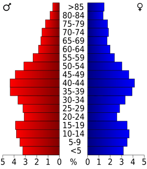
About 25.5% of the population was under 18 years old. The average age in the county was 37 years. For every 100 females, there were about 100.6 males.
Communities in Sheboygan County
Sheboygan County is home to many different cities, villages, and towns.
Main Cities
Here are the largest cities in Sheboygan County:
| Rank | Community | Population | Year | Zip Code |
| 1 | Sheboygan | 49,929 | 1846 | 53081 |
| 2 | Plymouth | 8,932 | 1880 | 53073 |
| 3 | Sheboygan Falls | 8,210 | 1835 | 53085 |
Charming Villages
- Adell
- Cascade
- Cedar Grove
- Elkhart Lake
- Glenbeulah
- Howards Grove
- Kohler
- Oostburg
- Random Lake
- Waldo
Local Towns
Special Communities
These are areas that the census bureau defines as specific places:
Smaller Communities
These are smaller places that are not officially cities, villages, or towns:
Historic Ghost Towns
High Schools in Sheboygan County
Here are some of the public high schools in the county:
- Elkhart Lake-Glenbeulah High School
- Étude High School
- Howards Grove High School
- Kohler High School
- North High School (Sheboygan)
- Oostburg High School
- Plymouth Comprehensive High School
- Random Lake High School
- Sheboygan Falls High School
- Sheboygan South High School
Law Enforcement: Sheboygan County Sheriff's Office
| Sheboygan County Sheriff's Office | |
|---|---|
| Agency overview | |
| Formed | 1846 |
| Employees | 180 |
| Annual budget | $17 million |
| Jurisdictional structure | |
| General nature | |
| Operational structure | |
| Headquarters | 525 North 6th Street Sheboygan, Wisconsin 53081 |
| Sworn members | 73 |
| Sheriff responsible |
|
| Facilities | |
| Stations | 1 |
| Patrol Boats | 2 |
| Patrol Dogs | 3 |
The Sheboygan County Sheriff's Office started in 1846. T.C. Horner was the first sheriff elected. For a while, the Sheriff's Office was in the David Taylor House. The county jail was in the basement of this house from 1915 to 1936. The sheriff and their family lived on the second floor.
In 1936, the Sheriff's Office and the county jail moved to the top floor of the Sheboygan County Courthouse. Later, in 1981, the Sheriff's Office moved to its current spot at the Law Enforcement Center. This new building had modern security systems. The second floor of this center was used as the county jail until 1998. That's when a new, larger Detention Center was built on the south side of the city.
In 2012, Sheboygan County and the City of Sheboygan agreed to combine their emergency dispatch services. This means that 911 calls for both the county and the city now go to one place. The new Joint Dispatch Center began working in 2016.
The current sheriff is Cory Roeseler. He was first elected to this role in 2018.
See also
 In Spanish: Condado de Sheboygan para niños
 | Victor J. Glover |
 | Yvonne Cagle |
 | Jeanette Epps |
 | Bernard A. Harris Jr. |


