
Van Dyne, Wisconsin facts for kids
Quick facts for kids
Van Dyne, Wisconsin
|
|
|---|---|
|
Census-designated place
|
|

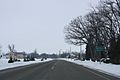
Looking south at downtown Van Dyne
|
|

Van Dyne, Wisconsin
Location in Wisconsin
|
|
| Country | |
| State | |
| County | Fond du Lac |
| Area | |
| • Total | 2.05 km2 (0.790 sq mi) |
| • Land | 2.04 km2 (0.788 sq mi) |
| • Water | 0.005 km2 (0.002 sq mi) |
| Elevation | 241 m (791 ft) |
| Population
(2020)
|
|
| • Total | 292 |
| • Density | 142.7/km2 (369.6/sq mi) |
| Time zone | UTC-6 (Central (CST)) |
| • Summer (DST) | UTC-5 (CDT) |
| ZIP Code |
54979
|
| Area code(s) | 920 |
| GNIS feature ID | 1584511 |
Van Dyne is a small community in Fond du Lac County, Wisconsin, United States. It's known as an unincorporated community and a census-designated place. This means it's a group of homes and businesses that isn't officially a city or town, but the government counts its population separately.
In 2020, about 292 people lived in Van Dyne. A main road, once part of the historic Yellowstone Trail and later Wisconsin Highway 175, runs north and south through the community. Today, this road is a county highway.
Contents
A Look Back: Van Dyne's History
Van Dyne was first planned out in 1866 by a person named Daniel Van Duyne. It became an important stop along the railroad line that connected the cities of Fond du Lac and Oshkosh. This made it a busy place for people traveling and sending goods. A post office has been helping people send and receive mail in Van Dyne ever since 1866.
Who Lives Here: Population Numbers
The number of people living in Van Dyne has changed a little over the years. Here's how the population has been counted:
| Historical population | |||
|---|---|---|---|
| Census | Pop. | %± | |
| 2010 | 279 | — | |
| 2020 | 292 | 4.7% | |
| U.S. Decennial Census | |||
Images for kids
-
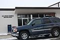
The Van Dyne Post Office
-
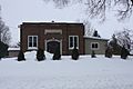
A school building in Van Dyne
-
A sign for Van Dyne along WIS 175


See also
 In Spanish: Van Dyne (Wisconsin) para niños
