Rosendale, Wisconsin facts for kids
Quick facts for kids
Rosendale, Wisconsin
|
|
|---|---|

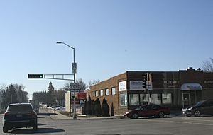
Downtown Rosendale at the intersection of WIS 23 / WIS 26
|
|

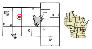
Location of Rosendale in Fond du Lac County, Wisconsin.
|
|
| Country | |
| State | |
| County | Fond du Lac |
| Area | |
| • Total | 1.24 sq mi (3.20 km2) |
| • Land | 1.23 sq mi (3.19 km2) |
| • Water | 0.00 sq mi (0.01 km2) |
| Elevation | 873 ft (266 m) |
| Population
(2020)
|
|
| • Total | 1,039 |
| • Density | 837.90/sq mi (323.51/km2) |
| Time zone | UTC-6 (Central (CST)) |
| • Summer (DST) | UTC-5 (CDT) |
| Zip Codes |
54974
|
| Area code(s) | 920 |
| FIPS code | 55-69550 |
| GNIS feature ID | 1572611 |
Rosendale is a small village located in Fond du Lac County, Wisconsin, in the United States. In 2020, about 1,039 people lived there. The village is partly in the Town of Rosendale and partly in the Town of Springvale.
Contents
Discovering Rosendale's Past
Rosendale got its name from the many wild rose bushes that grew in a valley, or 'dale,' near where the village first started.
Rosendale's Location and Size
Rosendale is found at specific map coordinates: 43.80962 degrees North and -88.673154 degrees West.
The United States Census Bureau says that the village covers a total area of about 1.22 square miles (3.16 square kilometers). All of this area is land.
Who Lives in Rosendale?
| Historical population | |||
|---|---|---|---|
| Census | Pop. | %± | |
| 1920 | 305 | — | |
| 1930 | 305 | 0.0% | |
| 1940 | 317 | 3.9% | |
| 1950 | 388 | 22.4% | |
| 1960 | 415 | 7.0% | |
| 1970 | 464 | 11.8% | |
| 1980 | 725 | 56.3% | |
| 1990 | 777 | 7.2% | |
| 2000 | 923 | 18.8% | |
| 2010 | 1,063 | 15.2% | |
| 2020 | 1,039 | −2.3% | |
| U.S. Decennial Census | |||
Population in 2020
According to the census from 2020, there were 1,039 people living in Rosendale. These people made up 400 households, with 267 of them being families. The village had about 837.9 people per square mile (323.5 people per square kilometer).
There were 413 houses or other living spaces. On average, there were about 333 housing units per square mile (128.6 per square kilometer). Most of the people living in the village, about 93.8%, were White. A smaller number were African American (0.3%), Native American (0.5%), or Asian (0.1%). About 2.6% of the population were from other races, and another 2.6% were from two or more races. People who identified as Hispanic or Latino made up 2.9% of everyone living in the village.
Population in 2010
The census from 2010 showed that 1,063 people lived in Rosendale. There were 407 households, and 299 of them were families. The population density was about 871.3 people per square mile (336.4 people per square kilometer).
There were 417 housing units, with an average of 341.8 units per square mile (132.0 per square kilometer). The racial makeup of the village was mostly White (96.0%). Other groups included African American (0.2%), Native American (0.9%), and Asian (0.4%). About 1.7% of the people were from other races, and 0.8% were from two or more races. About 3.0% of the population was Hispanic or Latino.
Getting Around Rosendale
Rosendale is located along Highway 23 and Highway 26. Highway 23 goes west towards Ripon and east towards Fond du Lac. Highway 26 goes north to Oshkosh and south to Waupun. Highway 26 is also a special alternate route for Interstate 41. The place where Highway 23 and Highway 26 meet used to have stop signs, which caused traffic to back up a lot during busy times. Now, there is a traffic light to help cars move more smoothly.
Historic Places in Rosendale
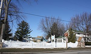
Rosendale is home to Sisson's Peony Gardens, which is a special place listed on the National Register of Historic Places. You can visit these gardens, and they even have an annual "Peony Sunday" in early June when the flowers are blooming beautifully.
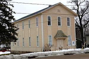
The Rosendale Historical Society has its main office on Main Street. Since 2001, this building has been used as a museum. It used to be the Independent Order of Odd Fellows Lodge No. 89, and it was added to the National Register in 2016. The Historical Society keeps many items and stories about the history of the village and the areas nearby.
Images for kids
See also
 In Spanish: Rosendale (Wisconsin) para niños
 | Toni Morrison |
 | Barack Obama |
 | Martin Luther King Jr. |
 | Ralph Bunche |


