
Jo Daviess County, Illinois facts for kids
Quick facts for kids
Jo Daviess County
|
|
|---|---|

Hill terrain in the county, part of the Driftless Area
|
|

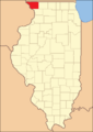
Location within the U.S. state of Illinois
|
|
 Illinois's location within the U.S. |
|
| Country | |
| State | |
| Founded | 1827 |
| Named for | Joseph Hamilton Daveiss |
| Seat | Galena |
| Largest city | Galena |
| Area | |
| • Total | 619 sq mi (1,600 km2) |
| • Land | 601 sq mi (1,560 km2) |
| • Water | 18 sq mi (50 km2) 2.9% |
| Population
(2020)
|
|
| • Total | 22,035 |
| • Estimate
(2023)
|
21,756 |
| • Density | 35.598/sq mi (13.744/km2) |
| Time zone | UTC−6 (Central) |
| • Summer (DST) | UTC−5 (CDT) |
| Congressional district | 16th |
Jo Daviess County is located in the very northwest corner of Illinois. In 2020, about 22,035 people lived there. The main town, or county seat, is Galena.
This county is part of the Tri-State Area, which means it's close to Dubuque, Iowa, and Platteville, Wisconsin. Jo Daviess County is special because it's part of the Driftless Area. This means it has hills and valleys, unlike most of flat Illinois. Charles Mound, the highest natural point in Illinois, is found here. In fact, eight of the ten highest points in Illinois are in Jo Daviess County!
Contents
History of Jo Daviess County
How Jo Daviess County Was Formed
Jo Daviess County was created in 1827. It was made from parts of Henry and Putnam counties. The county is named after Major Joseph Hamilton Daveiss. He was a lawyer for the United States in Kentucky. He sadly died in 1811 during a battle called the Battle of Tippecanoe. People in the area usually say his name like "Davis."
Early Settlers and Their Background
The first people to settle Jo Daviess County came from New England. These were "Yankee" immigrants. This means their families were originally English Puritans who settled New England in the 1600s. When the Erie Canal was finished, many more people from New England moved to this area. Back then, it was called the Northwest Territory.
After the Black Hawk War ended, even more people moved here. Most of them still came from the six New England states. They moved because there were too many people and not enough land in New England. Some settlers came from upstate New York. Their parents had moved there from New England after the Revolutionary War. For many years, most people in Jo Daviess County were from New England or had New England roots.
These early settlers were often part of the Congregational Church. However, during a time called the Second Great Awakening, many became Methodists or Baptists. Today, some parts of the Congregational Church, including those in Jo Daviess County, are known as the Church of Christ or the United Church of Christ.
Because of their New England background, most people in Jo Daviess County strongly supported the movement to end slavery. This was true in the years leading up to the Civil War.
Later Immigrants to the County
In the late 1880s and early 1890s, people of Irish and German heritage started moving into Jo Daviess County. Most of them didn't come directly from Ireland or Germany. Instead, they moved from other parts of the Midwest, especially Ohio, where they had been living.
How the County Borders Changed Over Time
- 1830: The northern border between Illinois and Wisconsin was officially set. Before this, some towns in Wisconsin were actually part of Jo Daviess County.
- 1831: Rock Island County was created from a part of Jo Daviess County. New northern parts of Henry and Putnam counties were also added.
- 1836: Whiteside, Ogle, and Winnebago counties were formed. They were made from the southern and eastern parts of Jo Daviess County.
- 1837: Stephenson County was created from the eastern part of Jo Daviess County.
- 1839: Carroll County was formed from the southern part of the county. This made Jo Daviess County its current size.
Geography and Nature

The U.S. Census Bureau says Jo Daviess County covers about 619 square miles. Most of this (601 square miles) is land, and about 18 square miles (2.9%) is water.
Weather and Climate in Jo Daviess County
| Weather chart for Galena, Illinois | |||||||||||||||||||||||||||||||||||||||||||||||
|---|---|---|---|---|---|---|---|---|---|---|---|---|---|---|---|---|---|---|---|---|---|---|---|---|---|---|---|---|---|---|---|---|---|---|---|---|---|---|---|---|---|---|---|---|---|---|---|
| J | F | M | A | M | J | J | A | S | O | N | D | ||||||||||||||||||||||||||||||||||||
|
1.1
27
9
|
1.3
33
14
|
2.3
45
25
|
3.3
59
36
|
3.7
71
47
|
4.6
81
57
|
3.3
84
62
|
4.4
82
60
|
3.6
74
51
|
2.5
62
39
|
2.6
45
27
|
1.6
32
16
|
||||||||||||||||||||||||||||||||||||
| temperatures in °F precipitation totals in inches source: The Weather Channel |
|||||||||||||||||||||||||||||||||||||||||||||||
|
Metric conversion
|
|||||||||||||||||||||||||||||||||||||||||||||||
In Galena, the county seat, average temperatures change a lot. In January, it's usually around 9°F. In July, it can reach 84°F. The coldest temperature ever recorded was -35°F in February 1996. The hottest was 103°F in August 1988.
The amount of rain and snow also varies. January usually gets about 1.14 inches of precipitation. June is the wettest month, with about 4.58 inches.
Important Roads in the County
![]() U.S. Route 20 is called the General Ulysses S. Grant Highway in Illinois. It's the longest road in the United States! In eastern Jo Daviess County, US 20 is one of the few places where it's still a two-lane road. The road between Dubuque and Stockton used to be known as very dangerous. This was because of its many hills, curves, cliffs, and valleys. Signs would warn drivers to be careful when entering this part of the road.
U.S. Route 20 is called the General Ulysses S. Grant Highway in Illinois. It's the longest road in the United States! In eastern Jo Daviess County, US 20 is one of the few places where it's still a two-lane road. The road between Dubuque and Stockton used to be known as very dangerous. This was because of its many hills, curves, cliffs, and valleys. Signs would warn drivers to be careful when entering this part of the road.
Other important roads include:
 Illinois Route 35
 Illinois Route 78
 Illinois Route 84
Neighboring Counties
Jo Daviess County shares borders with several other counties:
- Lafayette County, Wisconsin - to the north
- Stephenson County - to the east
- Carroll County - to the south
- Jackson County, Iowa - to the southwest
- Dubuque County, Iowa - to the west
- Grant County, Wisconsin - to the northwest
Protected Natural Areas
Jo Daviess County has several areas set aside to protect nature:
- Upper Mississippi River National Wildlife and Fish Refuge (part of it is here)
- Apple River Canyon State Park
The charitable organization Jo Daviess Conservation Foundation also protects several local areas:
- Buehler Preserve
- Casper Bluff Land & Water Reserve
- Horseshoe Mound
- Schurmeier Teaching Forest
- Valley of Eden Bird Sanctuary
- Wapello Land & Water Reserve
People and Population
| Historical population | |||
|---|---|---|---|
| Census | Pop. | %± | |
| 1830 | 2,111 | — | |
| 1840 | 6,180 | 192.8% | |
| 1850 | 18,604 | 201.0% | |
| 1860 | 27,325 | 46.9% | |
| 1870 | 27,820 | 1.8% | |
| 1880 | 27,528 | −1.0% | |
| 1890 | 25,101 | −8.8% | |
| 1900 | 24,533 | −2.3% | |
| 1910 | 22,657 | −7.6% | |
| 1920 | 21,917 | −3.3% | |
| 1930 | 20,235 | −7.7% | |
| 1940 | 19,989 | −1.2% | |
| 1950 | 21,459 | 7.4% | |
| 1960 | 21,821 | 1.7% | |
| 1970 | 21,766 | −0.3% | |
| 1980 | 23,520 | 8.1% | |
| 1990 | 21,821 | −7.2% | |
| 2000 | 22,289 | 2.1% | |
| 2010 | 22,691 | 1.8% | |
| 2020 | 22,035 | −2.9% | |
| 2023 (est.) | 21,756 | −4.1% | |
| U.S. Decennial Census 1790-1960 1900-1990 1990-2000 2010 |
|||

In 2010, there were about 22,678 people living in Jo Daviess County. They lived in 9,753 homes, with 6,514 of those being families. On average, there were about 38 people per square mile.
Most people in the county were white (97.2%). A small number were Black or African American (0.5%), Asian (0.3%), or American Indian (0.2%). About 2.7% of the population was of Hispanic or Latino background.
Many people had German (49.4%), Irish (19.7%), or English (11.1%) family backgrounds. The average age in the county was 47.1 years old.
Towns and Villages
Cities in Jo Daviess County
- East Dubuque
- Galena (This is the county seat, where the main government offices are.)
Villages in Jo Daviess County
Special Communities (Census-Designated Places)

Townships in Jo Daviess County
Jo Daviess County is divided into twenty-three smaller areas called townships:
- Apple River
- Berreman
- Council Hill
- Derinda
- Dunleith
- East Galena
- Elizabeth
- Guilford
- Hanover
- Menominee
- Nora
- Pleasant Valley
- Rawlins
- Rice
- Rush
- Scales Mound
- Stockton
- Thompson
- Vinegar Hill
- Wards Grove
- Warren
- West Galena
- Woodbine
Other Small Communities (Unincorporated)
These are smaller places that are not officially cities or villages:
Historic Sites to Visit
Education in Jo Daviess County
Here are the school districts in Jo Daviess County that serve students from kindergarten through 12th grade:
- East Dubuque Community Unit School District 119
- Galena Unit School District 120
- Lena-Winslow Community Unit School District 202
- Pearl City Community Unit School District 200
- River Ridge Community Unit School District 210
- Scales Mound Community Unit School District 211
- Stockton Community Unit School District 206
- Warren Community Unit School District 205
- West Carroll Community Unit School District 314
Images for kids
-
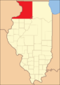
Jo Daviess County when it was first created (1827-1831). The Wisconsin border change isn't shown here.
-
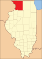
Jo Daviess County between 1831 and 1836.
-
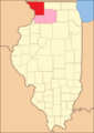
Jo Daviess County between 1836 and 1837. Whiteside and Ogle counties were still connected until their own governments were set up.
-
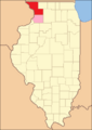
Jo Daviess County between 1837 and 1839.
-
Jo Daviess County became its current size in 1839 after Carroll County was created and Whiteside County's government was organized.


See also
 In Spanish: Condado de Jo Daviess para niños
