Dubuque County, Iowa facts for kids
Quick facts for kids
Dubuque County
|
||
|---|---|---|

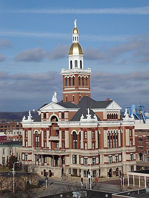
The Dubuque County Courthouse is an example of Beaux-Arts architecture.
|
||
|
||

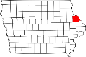
Location within the U.S. state of Iowa
|
||
 Iowa's location within the U.S. |
||
| Country | ||
| State | ||
| Founded | 1834 | |
| Named for | Julien Dubuque | |
| Seat | Dubuque | |
| Largest city | Dubuque | |
| Area | ||
| • Total | 617 sq mi (1,600 km2) | |
| • Land | 608 sq mi (1,570 km2) | |
| • Water | 8.3 sq mi (21 km2) 1.4% | |
| Population
(2020)
|
||
| • Total | 99,266 | |
| • Density | 160.88/sq mi (62.12/km2) | |
| Time zone | UTC−6 (Central) | |
| • Summer (DST) | UTC−5 (CDT) | |
| Congressional district | 2nd | |
Dubuque County is a county in the state of Iowa, USA. It is located in the northeastern part of the state. In 2020, about 99,266 people lived here. This makes it the eighth-largest county in Iowa by population.
The main city and county seat is Dubuque. The county is named after Julien Dubuque. He was the first European settler to live in Iowa. Dubuque County is part of the Dubuque, Iowa, Metropolitan Statistical Area. This means it's a big area with a main city and nearby towns that are closely connected.
Contents
History of Dubuque County
How Dubuque County Began
Dubuque County is named after Julien Dubuque. He was a French trader and one of the first Europeans to settle in Iowa. He was also a pioneer in lead mining in this area. Julien Dubuque was French Canadian. He had a good relationship with the local Meskwaki people.
He and other early settlers started a successful business. They mined lead and traded goods. When the lead mines started to run out, people found new ways to make a living. They began building boats, working with lumber, milling, brewing, and making machines.
The city of Dubuque was officially started in 1833. It was the first city in Iowa. This led to many people moving to the areas around it. The Roman Catholic Church encouraged this growth. They sent priests, bishops, and nuns to build churches. Many Irish and German immigrants, who were often Catholic, came to the region.
Growing and Changing Times
In September 1834, the Michigan Territory divided the Iowa District into two counties. The northern part was named Dubuque County. The southern part was called Demoine County. At that time, Dubuque County was much larger than it is today. It even included parts of what are now Minnesota, North Dakota, and South Dakota.
Dubuque County became part of the Wisconsin Territory in 1836. Its size was greatly reduced in 1837. Its original large area was split into 13 new counties. The land in present-day Minnesota and the Dakotas went to a new county called Fayette. Dubuque County then became part of the Iowa Territory in 1838.
In 1858, Saint Francis Catholic Church was built in Dubuque County.
Challenges and Recovery
In the 1980s, a "farm crisis" hit the Midwest, including Dubuque County. This was a tough time for farmers. Many businesses linked to farming, like Deere and Company, struggled. The Dubuque Packing Company also closed. This caused many people to lose their jobs.
In 1982, Dubuque County had 23% unemployment in one month. This was the highest in the nation. Many workers left the area to find jobs elsewhere. The county did not fully recover until the late 1990s. The economy then became more diverse. It shifted from mostly manufacturing to different service jobs. Today, the county is growing and doing well.
Modern Dubuque County
Since the 1990s, the area has become much more successful. Today, many people have jobs, and the population is growing. You can see this growth especially on the west side of the City of Dubuque. Nearby towns like Peosta and Asbury have also grown a lot. People are now thinking about how to manage this growth. This is a big change from 20 years ago.
Dubuque County is one of Iowa's two original counties. The other is Des Moines County. Both were created by the Michigan Territorial government in 1834.
In 2021, the Dubuque County Minutemen baseball team did very well. They reached the semi-finals of the American Legion World Series. This was the first team from Iowa to go that far since 1975.
Geography of Dubuque County
Land and Water Features
Dubuque County shares borders with Illinois and Wisconsin. The Mississippi River forms its northeast border. The county covers about 617 square miles. Most of this is land (608 square miles), and a small part is water (8.3 square miles). The Maquoketa River has north and south branches that flow through the county.
The county seat, Dubuque, is on the Mississippi River. It is in the east-central part of the county. Eastern Dubuque County looks very different from the western part. The eastern part has many steep hills, bluffs, and deep valleys. It also has more trees. The western part is mostly rolling farmland.
Dubuque County is famous for its tall bluffs along the Mississippi River. These bluffs are part of Iowa's Coulee Region, also called the Driftless Area. During the last ice age, glaciers missed this area. This is why the land here is unusually rugged, unlike the flatter areas around it.
Parks and Outdoor Fun
The Iowa Department of Natural Resources manages three park and preserve areas in the county:
- Little Maquoketa River Mounds State Preserve
- Mines of Spain State Recreation Area/E. B. Lyons Nature Center
- White Pine Hollow State Forest
The Dubuque County Conservation Board manages 11 park and recreation areas:
- Bankston Park
- Fillmore Recreation Area & Fairways
- Finley's Landing Park
- Heritage Trail & Pond
- Interstate Power Forest Preserve
- Massey Marina Park
- Mud Lake Park
- New Wine Park
- Pohlman Prairie Preserve
- Swiss Valley Nature Park & Preserve
- Whitewater Canyon Park
The City of Dubuque and other towns also have their own public parks.
Main Roads and Transportation
Here are the major highways in Dubuque County:
For local travel, The Jule provides public transportation.
Neighboring Counties
Dubuque County is next to these counties:
- Clayton County (north)
- Grant County, Wisconsin (northeast)
- Jo Daviess County, Illinois (east)
- Jackson County (southeast)
- Jones County (southwest)
- Delaware County (west)
Protected Natural Areas
Parts of these national protected areas are in Dubuque County:
People of Dubuque County (Demographics)
| Historical population | |||
|---|---|---|---|
| Census | Pop. | %± | |
| 1840 | 3,059 | — | |
| 1850 | 10,841 | 254.4% | |
| 1860 | 31,164 | 187.5% | |
| 1870 | 38,969 | 25.0% | |
| 1880 | 42,996 | 10.3% | |
| 1890 | 49,848 | 15.9% | |
| 1900 | 56,403 | 13.1% | |
| 1910 | 57,450 | 1.9% | |
| 1920 | 58,262 | 1.4% | |
| 1930 | 61,214 | 5.1% | |
| 1940 | 63,768 | 4.2% | |
| 1950 | 71,337 | 11.9% | |
| 1960 | 80,048 | 12.2% | |
| 1970 | 90,609 | 13.2% | |
| 1980 | 93,745 | 3.5% | |
| 1990 | 86,403 | −7.8% | |
| 2000 | 89,143 | 3.2% | |
| 2010 | 93,653 | 5.1% | |
| 2020 | 99,266 | 6.0% | |
| 2023 (est.) | 98,887 | 5.6% | |
| U.S. Decennial Census 1790-1960 1900-1990 1990-2000 2010-2019 |
|||
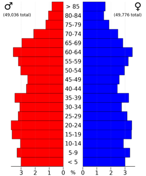
The 2020 census counted 99,266 people in Dubuque County. This means there were about 160 people per square mile. There were 42,630 homes, and 39,891 of them were lived in.
Here's a look at the different groups of people living in Dubuque County in 2020:
| Race | Num. | Perc. |
|---|---|---|
| White (not Hispanic) | 87,349 | 88% |
| Black or African American (not Hispanic) | 4,035 | 4.1% |
| Native American (not Hispanic) | 131 | 0.13% |
| Asian (not Hispanic) | 1,018 | 1.02% |
| Pacific Islander (not Hispanic) | 813 | 0.82% |
| Other/Mixed (not Hispanic) | 2,943 | 3% |
| Hispanic or Latino | 2,977 | 3% |
Economy and Jobs
How People Make a Living
In the past, Dubuque County's economy relied a lot on big factories. Companies like Deere and Company and the Dubuque Packing Company were very important. But over the last 20 years, the economy has changed a lot. Now, besides manufacturing, many people work in other areas. These include tourism, gaming (like casinos), healthcare, education, publishing, and financial services.
Most of the county's economy is centered around businesses in the City of Dubuque. Some industrial areas are also found in Cascade, Dyersville, and Peosta. The rest of the county is mostly rural and focused on farming.
Some of the key companies in Dubuque County are:
- Deere and Company
- Eagle Window & Door Co.
- Flexsteel Industries
- Mi-T-M Corp.
- A.Y. McDonald Mfg. Co.
- Klauer Mfg.
- Georgia-Pacific
- Swiss Valley Farms
Many people also work for large organizations like:
- Dubuque Community School District
- Mercy Medical Center - Dubuque
- Medical Associates
- Finley Hospital
- Prudential Financial
- The City of Dubuque
- Cottingham & Butler
Economic Growth
Recently, Dubuque County has seen a lot of job growth. Unemployment rates are low, and businesses are expanding quickly. Along with these good changes, the county's population is also growing. The population was about 86,403 in 1990. Now, it's around 97,000 and still increasing.
This growth is very important. Most counties around Dubuque County have fewer people now than they did in 1900. The only exception is Grant County, Wisconsin. This shows how much Dubuque County has improved.
Education in Dubuque County
Colleges and Universities
Dubuque County has several places for higher education:
- Capri Cosmetology College
- Clarke University
- Divine Word College
- Emmaus Bible College
- Loras College
- Northeast Iowa Community College
- University of Dubuque
- Wartburg Theological Seminary
Local School Districts
Here are the school districts for K-12 students:
- Dubuque Community School District
- Maquoketa Community School District
- Monticello Community School District
- Western Dubuque Community School District
Religion
As of 2022, a large number of people in Dubuque County are Catholic.
Communities in Dubuque County
Cities and Towns
Small Unincorporated Communities
These are smaller places that are not officially cities:
Townships
Dubuque County is divided into eighteen townships:
- Cascade
- Center
- Concord
- Dodge
- Dubuque
- Iowa
- Jefferson
- Julien
- Liberty
- Mosalem
- New Wine
- Peru
- Prairie Creek
- Table Mound
- Taylor
- Vernon
- Washington
- Whitewater
City Population Ranking
Here are the cities in Dubuque County, ranked by how many people live there:
| Rank | City | 2020 City Population | 2010 City Population | Change |
|---|---|---|---|---|
| 1 | Dubuque† | 59,667 | 57,637 | +3.52% |
| 2 | Asbury | 5,943 | 4,170 | +42.52% |
| 3 | Dyersville (partially in Delaware County) | 4,477 | 4,058 | +10.33% |
| 4 | Cascade (partially in Jones County) | 2,386 | 2,159 | +10.51% |
| 5 | Epworth | 2,023 | 1,860 | +8.76% |
| 6 | Peosta | 1,908 | 1,377 | +38.56% |
| 7 | Farley | 1,766 | 1,537 | +14.90% |
| 8 | New Vienna | 382 | 407 | −6.14% |
| 9 | Worthington | 382 | 401 | −4.74% |
| 10 | Holy Cross | 356 | 374 | −4.81% |
| 11 | Luxemburg | 245 | 240 | +2.08% |
| 12 | Rickardsville | 202 | 182 | +10.99% |
| 13 | Sherrill | 189 | 177 | +6.78% |
| 14 | Centralia | 116 | 134 | −13.43% |
| 15 | Bernard | 114 | 112 | +1.79% |
| 16 | Sageville | 95 | 122 | −22.13% |
| 17 | Zwingle (partially in Jackson County) | 84 | 91 | −7.69% |
| 18 | Balltown | 79 | 68 | +16.18% |
| 19 | Bankston | 23 | 25 | −8.00% |
| 20 | Durango | 20 | 22 | −9.09% |
See also
 In Spanish: Condado de Dubuque para niños
 | Sharif Bey |
 | Hale Woodruff |
 | Richmond Barthé |
 | Purvis Young |


