Clayton County, Iowa facts for kids
Quick facts for kids
Clayton County
|
|
|---|---|
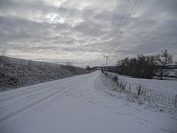
Winter scene near Elkader
|
|
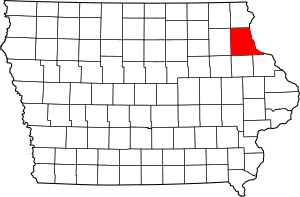
Location within the U.S. state of Iowa
|
|
 Iowa's location within the U.S. |
|
| Country | |
| State | |
| Founded | 1837 |
| Named for | John M. Clayton |
| Seat | Elkader |
| Largest city | Guttenberg |
| Area | |
| • Total | 793 sq mi (2,050 km2) |
| • Land | 779 sq mi (2,020 km2) |
| • Water | 14 sq mi (40 km2) 1.8% |
| Population
(2020)
|
|
| • Total | 17,043 |
| • Density | 21.492/sq mi (8.298/km2) |
| Time zone | UTC−6 (Central) |
| • Summer (DST) | UTC−5 (CDT) |
| Congressional district | 1st |
Clayton County is a special area of land in the state of Iowa, USA. It's like a big neighborhood with its own local government. In 2020, about 17,043 people lived here. The main town, or county seat, where the county government offices are, is Elkader.
Clayton County was created in 1837. It was named after a famous person named John M. Clayton. He was a Senator from Delaware and later worked for President Zachary Taylor as the Secretary of State.
Exploring Clayton County's Land
Clayton County covers a total area of about 793 square miles. Most of this is land, about 779 square miles. The rest, about 14 square miles, is water. This makes it the fifth-largest county in Iowa by size.
Neighboring Counties
Clayton County shares its borders with several other counties:
- Allamakee County (north)
- Crawford County, Wisconsin (northeast)
- Grant County, Wisconsin (east)
- Dubuque County (southeast)
- Delaware County (south)
- Buchanan County (southwest)
- Fayette County (west)
- Winneshiek County (northwest)
Main Roads and Highways
Many important roads run through Clayton County, helping people travel around.
Protected Natural Areas
Parts of these special natural areas are found in Clayton County:
- Driftless Area National Wildlife Refuge (a place for wildlife)
- Effigy Mounds National Monument (ancient earth mounds)
- Upper Mississippi River National Wildlife and Fish Refuge (another wildlife area)
Unique Land Features
Clayton County is part of a special region called the Driftless Area. This area was not covered by ice during the last ice age. Because of this, its rivers have carved deep valleys. The Mississippi River also has amazing tall cliffs, called bluffs, along its banks.
People and Population
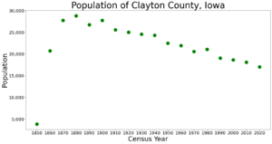
| Historical population | |||
|---|---|---|---|
| Census | Pop. | %± | |
| 1850 | 3,873 | — | |
| 1860 | 20,728 | 435.2% | |
| 1870 | 27,771 | 34.0% | |
| 1880 | 28,829 | 3.8% | |
| 1890 | 26,733 | −7.3% | |
| 1900 | 27,750 | 3.8% | |
| 1910 | 25,576 | −7.8% | |
| 1920 | 25,032 | −2.1% | |
| 1930 | 24,559 | −1.9% | |
| 1940 | 24,334 | −0.9% | |
| 1950 | 22,522 | −7.4% | |
| 1960 | 21,962 | −2.5% | |
| 1970 | 20,606 | −6.2% | |
| 1980 | 21,098 | 2.4% | |
| 1990 | 19,054 | −9.7% | |
| 2000 | 18,678 | −2.0% | |
| 2010 | 18,129 | −2.9% | |
| 2020 | 17,043 | −6.0% | |
| 2023 (est.) | 16,969 | −6.4% | |
| U.S. Decennial Census 1790-1960 1900-1990 1990-2000 2010-2018 |
|||
2020 Population Count
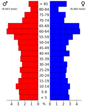
In 2020, a count of the population showed that 17,043 people lived in Clayton County. This means there were about 22 people living in each square mile. Most people, about 93 out of every 100, were non-Hispanic White. There were 8,758 homes, and 7,315 of them were lived in.
2010 Population Count
The 2010 population count found 18,130 people living in the county. There were 8,999 homes, and 7,599 of them were lived in.
Towns and Villages
Cities in Clayton County
These are the cities you can find in Clayton County:
Smaller Communities (Unincorporated)
These are smaller places that are not officially cities:
- Beulah
- Ceres
- Clayton Center
- Communia
- Eckards
- Fairview
- Froelich
- Giard
- Gunder
- Hardin
- Highland
- Littleport
- McGregor Heights
- Mederville
- Millville
- Motor
- Osborne
- Saint Sebald
- Thomasville
- Turkey River
- Updegraff
- Watson
- Wood
County Divisions (Townships)
Clayton County is also divided into these smaller areas called townships:
- Boardman
- Buena Vista
- Cass
- Clayton
- Cox Creek
- Elk
- Farmersburg
- Garnavillo
- Giard
- Grand Meadow
- Highland
- Jefferson
- Lodomillo
- Mallory
- Marion
- Mendon
- Millville
- Monona
- Read
- Sperry
- Volga
- Wagner
City Population Sizes (2020)
Here is a list of the cities and towns in Clayton County, ranked by how many people lived there in 2020. † This symbol means it's the county seat, the main town.
| Rank | City/Town/etc. | Population (2020 Census) |
|---|---|---|
| 1 | Postville (partially in Allamakee County) | 2,503 |
| 2 | Guttenberg | 1,817 |
| 3 | Monona | 1,471 |
| 4 | † Elkader | 1,209 |
| 5 | Strawberry Point | 1,155 |
| 6 | Edgewood (partially in Delaware County) | 909 |
| 7 | Garnavillo | 763 |
| 8 | McGregor | 742 |
| 9 | Marquette | 429 |
| 10 | Luana | 301 |
| 11 | Farmersburg | 271 |
| 12 | Volga | 203 |
| 13 | North Buena Vista | 109 |
| 14 | St. Olaf | 106 |
| 15 | Garber | 76 |
| 16 | Clayton | 45 |
| 17 | Osterdock | 43 |
| 18 | Elkport | 29 |
See also
 In Spanish: Condado de Clayton (Iowa) para niños
 | William L. Dawson |
 | W. E. B. Du Bois |
 | Harry Belafonte |


