Winneshiek County, Iowa facts for kids
Quick facts for kids
Winneshiek County
|
||
|---|---|---|
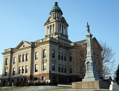
Courthouse and Civil War Monument located in Decorah
|
||
|
||
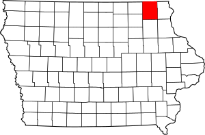
Location within the U.S. state of Iowa
|
||
 Iowa's location within the U.S. |
||
| Country | ||
| State | ||
| Founded | 1847 | |
| Named for | Chief Winneshiek | |
| Seat | Decorah | |
| Largest city | Decorah | |
| Area | ||
| • Total | 690 sq mi (1,800 km2) | |
| • Land | 690 sq mi (1,800 km2) | |
| • Water | 0.3 sq mi (0.8 km2) 0.04% | |
| Population
(2020)
|
||
| • Total | 20,070 | |
| • Density | 29.09/sq mi (11.23/km2) | |
| Time zone | UTC−6 (Central) | |
| • Summer (DST) | UTC−5 (CDT) | |
| Congressional district | 1st | |
Winneshiek County is a special area in the state of Iowa, USA. Think of a county as a smaller part of a state, like a big neighborhood with its own local government. The main city and center of the county is Decorah. In 2020, about 20,070 people lived here.
Contents
History of Winneshiek County
Winneshiek County is mostly made up of farms and open land. It has a very interesting history because many different groups of people came to live here. These include families from Czech, Slovak, English, Irish, German, Swiss, and Norwegian backgrounds.
The first settlers arrived in 1848. They built homes in areas that are now near Castalia, Iowa and Fort Atkinson, Iowa. The county itself was officially created in 1847. It was named after Chief Winneshiek, a leader of the Winnebago Native American tribe.
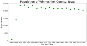
In 1980, Winneshiek County had about 21,842 people. Like many parts of Iowa, the number of people living here went down a bit in the 1980s. By 1990, the population was 20,847. But in the 1990s, more people started moving to the county, and the population grew back to over 21,000.
Geography of Winneshiek County
Winneshiek County covers a total area of about 690 square miles. Almost all of this area is land, with only a tiny bit (0.04%) being water.
Main Roads in the County
These are the most important highways that help people travel through Winneshiek County:
Neighboring Counties
Winneshiek County shares its borders with several other counties:
- To the northwest: Fillmore County, Minnesota
- To the northeast: Houston County, Minnesota
- To the east: Allamakee County
- To the south: Fayette County
- To the southwest: Chickasaw County
- To the west: Howard County
- To the southeast: Clayton County
People of Winneshiek County
The number of people living in Winneshiek County has changed over the years. Here's a quick look at the population from different census counts:
| Historical population | |||
|---|---|---|---|
| Census | Pop. | %± | |
| 1850 | 546 | — | |
| 1860 | 13,942 | 2,453.5% | |
| 1870 | 23,570 | 69.1% | |
| 1880 | 23,938 | 1.6% | |
| 1890 | 22,528 | −5.9% | |
| 1900 | 23,731 | 5.3% | |
| 1910 | 21,729 | −8.4% | |
| 1920 | 22,091 | 1.7% | |
| 1930 | 21,630 | −2.1% | |
| 1940 | 22,263 | 2.9% | |
| 1950 | 21,639 | −2.8% | |
| 1960 | 21,651 | 0.1% | |
| 1970 | 21,758 | 0.5% | |
| 1980 | 21,876 | 0.5% | |
| 1990 | 20,847 | −4.7% | |
| 2000 | 21,310 | 2.2% | |
| 2010 | 21,056 | −1.2% | |
| 2020 | 20,070 | −4.7% | |
| 2023 (est.) | 19,815 | −5.9% | |
| U.S. Decennial Census 1790-1960 1900-1990 1990-2000 2010-2018 |
|||
What the 2020 Census Shows
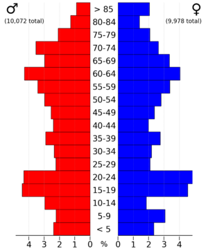
In 2020, the census counted 20,070 people in Winneshiek County. This means there were about 29 people living in each square mile. Most people (97.20%) said they belonged to one race. There were 8,916 homes, and 8,170 of them were lived in.
Here's a breakdown of the different groups of people living in Winneshiek County in 2020:
| Race | Number of People | Percentage of Total |
|---|---|---|
| White | 18,705 | 93.2% |
| Black or African American | 119 | 0.6% |
| Native American | 19 | 0.1% |
| Asian | 178 | 0.9% |
| Pacific Islander | 12 | 0.06% |
| Other/Mixed Race | 452 | 2.3% |
| Hispanic or Latino | 585 | 3% |
Communities in Winneshiek County
Winneshiek County has several cities and smaller communities where people live.
Cities in the County
Other Communities
- Burr Oak (This is a "census-designated place," meaning it's a community that's not officially a city but is recognized for census counting.)
- Bluffton
- Festina
- Frankville
- Freeport
- Highlandville
- Hesper
- Kendallville
Townships in the County
A township is a small area of land, usually with a local government, that helps manage things like roads and services for people living there.
- Bloomfield
- Bluffton
- Burr Oak
- Calmar
- Canoe
- Decorah
- Frankville
- Fremont
- Glenwood
- Hesper
- Highland
- Jackson
- Lincoln
- Madison
- Military
- Orleans
- Pleasant
- Springfield
- Sumner
- Washington
Places That Used to Be Towns
Some places in Winneshiek County that were once towns are now called "ghost towns" because most people have moved away.
- Conover
- Moneek
- Sattre
- Canoe
Population Ranking of Communities
Here's a list of the cities and communities in Winneshiek County, ranked by how many people lived there in 2020. † county seat (the main city of the county)
| Rank | City/Town/Community | Type | Population (2020 Census) |
|---|---|---|---|
| 1 | † Decorah | City | 7,587 |
| 2 | Calmar | City | 1,125 |
| 3 | Ossian | City | 802 |
| 4 | Spillville | City | 385 |
| 5 | Fort Atkinson | City | 312 |
| 6 | Ridgeway | City | 275 |
| 7 | Burr Oak | CDP | 171 |
| 8 | Castalia | City | 145 |
| 9 | Jackson Junction | City | 37 |
Education in Winneshiek County
Schools are very important in Winneshiek County. Here are the school districts that have their main offices in the county:
- Decorah Community School District
- South Winneshiek Community School District
- Turkey Valley Community School District
The North Winneshiek Community School District used to be in the county. However, it joined with the Decorah Community School District on July 1, 2018. The Decorah district also has a special agreement with the Mabel-Canton Public Schools in Minnesota. This means that students who live in the Decorah district but are closer to the Mabel-Canton schools can choose to go to those schools instead.
Some other school districts have their main offices outside of Winneshiek County, but they still serve parts of the county:
- Allamakee Community School District
- Howard–Winneshiek Community School District
- Postville Community School District
Images for kids
See also
 In Spanish: Condado de Winneshiek para niños
 | Aaron Henry |
 | T. R. M. Howard |
 | Jesse Jackson |


