Fort Atkinson, Iowa facts for kids
Quick facts for kids
Fort Atkinson, Iowa
|
|
|---|---|

Iowa-24 runs through town
|
|

Location of Fort Atkinson, Iowa
|
|
| Country | United States |
| State | Iowa |
| County | Winneshiek |
| Incorporated | June 5, 1895 |
| Area | |
| • Total | 0.32 sq mi (0.82 km2) |
| • Land | 0.32 sq mi (0.82 km2) |
| • Water | 0.00 sq mi (0.00 km2) |
| Elevation | 1,047 ft (319 m) |
| Population
(2020)
|
|
| • Total | 312 |
| • Density | 981.13/sq mi (379.31/km2) |
| Time zone | UTC-6 (Central (CST)) |
| • Summer (DST) | UTC-5 (CDT) |
| ZIP code |
52144
|
| Area code(s) | 563 |
| FIPS code | 19-28425 |
| GNIS feature ID | 0456681 |
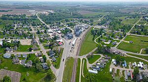
Fort Atkinson is a small city in Winneshiek County, Iowa. In 2020, about 312 people lived there. It is known for the historic Fort Atkinson State Preserve. Every September, the city hosts a big event called a fur-trapper rendezvous. Fort Atkinson also has the largest hay auction in the area every Wednesday.
Contents
The Story of Fort Atkinson
Fort Atkinson was built a long time ago, starting in 1840. It was finished by 1842. The fort was made to help protect the Ho-Chunk people (also known as Winnebago). They were being moved from Wisconsin at that time. The fort is named after Henry Atkinson, who was a leader in the army.
Later, the regular army soldiers left the fort. They were needed for a war called the Mexican–American War. Iowa volunteers took over for a while. The fort was finally left empty on February 14, 1849. This happened after the Ho-Chunk people had moved from Iowa.
Where Fort Atkinson Is
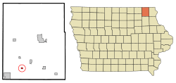
Fort Atkinson is located in the state of Iowa. It is found at these coordinates: 43°8′39″N 91°56′5″W / 43.14417°N 91.93472°W.
The United States Census Bureau says the city covers a total area of about 0.31 square miles (0.80 square kilometers). All of this area is land.
How Many People Live Here
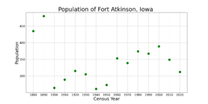
| Historical populations | ||
|---|---|---|
| Year | Pop. | ±% |
| 1880 | 435 | — |
| 1890 | 480 | +10.3% |
| 1900 | 264 | −45.0% |
| 1910 | 289 | +9.5% |
| 1920 | 315 | +9.0% |
| 1930 | 305 | −3.2% |
| 1940 | 261 | −14.4% |
| 1950 | 273 | +4.6% |
| 1960 | 353 | +29.3% |
| 1970 | 339 | −4.0% |
| 1980 | 374 | +10.3% |
| 1990 | 367 | −1.9% |
| 2000 | 389 | +6.0% |
| 2010 | 349 | −10.3% |
| 2020 | 312 | −10.6% |
| Source: and Iowa Data Center Source: |
||
2020 Population Count
In 2020, the census showed that 312 people lived in Fort Atkinson. There were 154 households and 95 families. The city had about 982 people per square mile (379 per square kilometer).
Most people living in the city were White (96.5%). A small number were from other racial backgrounds. About 2.6% of the people were Hispanic or Latino.
About 23.4% of households had children under 18 living with them. The average age of people in the city was 48 years old. About 19.2% of residents were under 20. Also, 25.6% were 65 years old or older. The city had slightly more males (52.9%) than females (47.1%).
2010 Population Count
In 2010, the census counted 349 people in Fort Atkinson. There were 160 households and 102 families. The population density was about 1,126 people per square mile (435 per square kilometer).
Most people were White (98.0%). About 3.2% of the population was Hispanic or Latino.
About 22.5% of households had children under 18. The average age was 47.3 years. About 20.3% of residents were under 18. Also, 25.2% were 65 or older. The city had about 49.6% males and 50.4% females.
Local Schools
Fort Atkinson is part of the Turkey Valley School District. This district is small, serving students from kindergarten to 12th grade. About 575 students attend schools in this district.
The district includes students from nearby towns like Lawler, Waucoma, St. Lucas, Protivin, Fort Atkinson, and Jackson Junction. The main schools are located in Jackson Junction.
There is also a private Catholic school in Protivin. It is called Trinity Catholic School.
Famous People
- Judson Dean Howard (around 1878 – 1961) was a cave expert. He helped create the Lava Beds National Monument in California.
See also
 In Spanish: Fort Atkinson (Iowa) para niños
 | Delilah Pierce |
 | Gordon Parks |
 | Augusta Savage |
 | Charles Ethan Porter |


