Lava Beds National Monument facts for kids
Quick facts for kids Lava Beds National Monument |
|
|---|---|
|
IUCN Category V (Protected Landscape/Seascape)
|
|
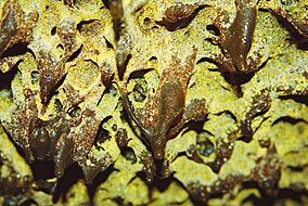
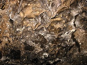
Lavacicles in Golden Dome Cave
|
|
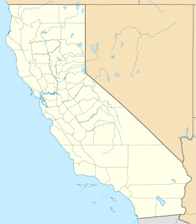
| Location | Siskiyou and Modoc counties, California, United States |
| Nearest city | Tulelake, California |
| Area | 46,692 acres (188.96 km2) |
| Established | November 21, 1925 |
| Visitors | 135,286 (in 2017) |
| Governing body | National Park Service |
| Website | Lava Beds National Monument |
|
Lava Beds National Monument Archeological District
|
|
| NRHP reference No. | 75002182 |
| Added to NRHP | 1991 |
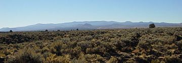
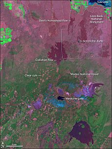
The Lava Beds National Monument is a super cool place in northeastern California. It's found in Siskiyou and Modoc counties. This monument sits on the side of the Medicine Lake Volcano. It covers the largest area of any volcano in the Cascade Range.
This special area is where three different land regions meet: Sierra-Klamath, Cascade, and Great Basin. The monument was created on November 21, 1925. It protects over 46,000 acres (190 km2) of amazing volcanic landscapes.
Lava Beds National Monument has tons of lava tubes. Twenty-five of these tubes have marked entrances and trails. This makes them easy for visitors to explore. The monument also has trails through its high desert and volcanic fields. In 1872 and 1873, this area was the site of the Modoc War. A group of Modoc people, led by Kintpuash (also known as Captain Jack), used the lava beds as a fort. The area called Captain Jack's Stronghold is named after him.
Contents
Awesome Volcanic Formations
Lava Beds National Monument is super important for geology. It has many different kinds of volcanic features. These include lava tubes, fumaroles (steam vents), cinder cones, spatter cones, pit craters, hornitos (small lava mounds), maars (volcanic craters), lava flows, and volcanic fields.
All these cool landforms were made by eruptions from the Medicine Lake Volcano. This volcano is a shield volcano, which means it's wide and gently sloped.
Volcanic Cones: Cinder and Spatter
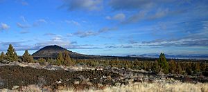
Cinder cones form when hot magma bursts out of the ground. It shoots into the air like a fountain. This lava cools into small pieces called cinders as it falls. These cinders pile up around the opening, creating a cone shape. After the pressure is gone, the rest of the lava flows from the bottom of the cone.
Some cinder cones here are very old, like Hippo Butte and Three Sisters. They are over 30,000 to 40,000 years old. Schonchin Butte formed about 62,000 years ago. The youngest lava flow in the monument is the Callahan flow, which is about 1,110 years old.
Spatter cones are made from thicker lava. This lava is thrown out and builds up in layers. It forms a chimney-like structure around the vent. Fleener Chimneys and Black Crater are examples of spatter cones.
Rivers of Lava: Flows
About 90% of the lava at Lava Beds is a type called basalt. There are two main kinds of basaltic lava flows: pahoehoe and ʻaʻā. Pahoehoe lava is smooth and often looks like ropes. It's the most common type here.
ʻAʻā lava forms when pahoehoe cools and loses some of its gases. It's rough, sharp, and jagged. The Devil's Homestead lava flow, which came from Fleener Chimneys, is a great example of ʻaʻā. Other types of lava, like andesitic and pumice, are also found. Pumice is a light, bubbly rock that rained down about 900 years ago from Glass Mountain.
The lava flows from Mammoth and Modoc Craters make up about two-thirds of the lava in the monument. The flows here range in age from 2 million years old to just 1,110 years old.
Ancient Lava Landscapes: Fields
Gillem Bluff is a large cliff formed by a fault. This happened as the land stretched and a section of earth dropped down. The rock layer on top of Gillem Bluff is 2 million years old. This tells us the rocks underneath are even older.
The oldest lava flow from the Medicine Lake Volcano in the monument is 450,000 years old. It's found near Captain Jack's Stronghold. Petroglyph Point was created about 275,000 years ago. This happened when cinders erupted through the shallow water of Tule Lake. This caused huge explosions of ash and steam.
Hidden Passages: Lava Tubes
Most of the lava tubes in the monument formed about 30,000 to 40,000 years ago. As hot basaltic lava flowed downhill, its top layer cooled and hardened. This created a crust that insulated the lava flowing underneath. This process formed the amazing lava tubes.
The cool formations called lavacicles on the ceiling of a lava tube formed as the lava level dropped. The sticky lava on the ceiling dripped as it cooled. Dripstone formed when lava splashed onto the inner walls of the tubes.
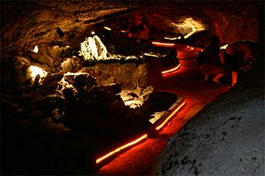
Lava Beds National Monument has the most lava tubes in North America. One tube has electric lights, making it easy to see. Other tubes need flashlights, which you can borrow at the monument.
Recent Earth Activity
In late 1988, a series of small earthquakes happened. These quakes were likely caused by the ground sinking in the volcano's caldera. Cracks in the ground show how the earth's movement and volcanic activity are connected. One big crack, called the Big Crack, runs along the northeastern edge of the monument.
Climate and Weather
Lava Beds National Monument is a high desert area. It gets about 14.8 in (376 mm) of rain each year. This includes about 44 in (110 cm) of snow. Summers are warm and dry, while winters are cold with some snow.
The average daily temperature ranges from 31.5 °F (−0.3 °C) in December to 68.0 °F (20.0 °C) in July. There are about 21 days a year when it gets hotter than 90 °F (32 °C). And about 10 days when the temperature stays below freezing. Freezing temperatures usually occur from late September to early June.
| Climate data for Lava Beds National Monument (1981–2010 normals) | |||||||||||||
|---|---|---|---|---|---|---|---|---|---|---|---|---|---|
| Month | Jan | Feb | Mar | Apr | May | Jun | Jul | Aug | Sep | Oct | Nov | Dec | Year |
| Record high °F (°C) | 62 (17) |
68 (20) |
75 (24) |
88 (31) |
94 (34) |
98 (37) |
103 (39) |
102 (39) |
99 (37) |
90 (32) |
74 (23) |
64 (18) |
103 (39) |
| Mean daily maximum °F (°C) | 41.9 (5.5) |
45.9 (7.7) |
50.9 (10.5) |
57.0 (13.9) |
65.7 (18.7) |
75.0 (23.9) |
84.8 (29.3) |
84.7 (29.3) |
76.8 (24.9) |
64.6 (18.1) |
48.6 (9.2) |
40.7 (4.8) |
61.4 (16.3) |
| Mean daily minimum °F (°C) | 22.9 (−5.1) |
24.6 (−4.1) |
27.8 (−2.3) |
31.6 (−0.2) |
38.0 (3.3) |
44.2 (6.8) |
51.1 (10.6) |
50.3 (10.2) |
44.0 (6.7) |
35.9 (2.2) |
27.3 (−2.6) |
22.3 (−5.4) |
35.0 (1.7) |
| Record low °F (°C) | −13 (−25) |
−13 (−25) |
3 (−16) |
11 (−12) |
19 (−7) |
24 (−4) |
29 (−2) |
30 (−1) |
21 (−6) |
9 (−13) |
2 (−17) |
−18 (−28) |
−18 (−28) |
| Average precipitation inches (mm) | 1.74 (44) |
1.84 (47) |
1.90 (48) |
1.12 (28) |
1.23 (31) |
0.92 (23) |
0.60 (15) |
0.46 (12) |
0.53 (13) |
1.04 (26) |
1.65 (42) |
1.72 (44) |
14.75 (373) |
| Average snowfall inches (cm) | 9.8 (25) |
8.3 (21) |
7.5 (19) |
3.5 (8.9) |
1.1 (2.8) |
0.1 (0.25) |
0 (0) |
0 (0) |
0 (0) |
0.3 (0.76) |
4.7 (12) |
8.6 (22) |
43.9 (111.71) |
| Average precipitation days (≥ 0.01 in) | 9.6 | 8.8 | 10.7 | 8.9 | 7.4 | 5.6 | 2.8 | 2.4 | 3.2 | 5.7 | 9.6 | 9.1 | 83.8 |
| Average snowy days (≥ 0.1 in) | 6.6 | 4.9 | 4.7 | 3.3 | 0.6 | 0.1 | 0 | 0 | 0 | 0.5 | 3.3 | 5.2 | 29.3 |
| Source: NOAA (extremes 1948–present) | |||||||||||||
Plants and Animals of Lava Beds
Amazing Plants (Flora)
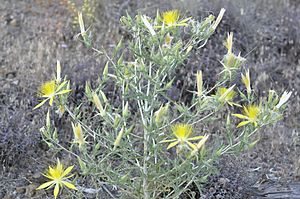
The lava tubes and rocky areas support many different plants. You can find a wide variety of lichens and mosses. Other plants include desert sweet (Chamaebatiaria millefolium) and purple desert sage (Salvia dorrii). The bright yellow blazing star (Mentzelia laevicaulis) also grows here.
Many types of ferns grow near cave entrances. These include the spreading wood fern (Dryopteris expansa) and the western swordfern (Polystichum munitum). It's surprising to see these ferns here. Their usual home is about 90–125 mi (145–201 km) west, along the northern California coast.
Cool Animals (Fauna)
Even though it's a dry, desert-like place, many animals live here. They have learned to survive with little water. There are no natural water sources on the surface in the monument. Some animals get water from caves. Others fly about 12 miles north to Tule Lake.
Many special animal species live here. These include different kinds of bats like the fringed myotis and Townsends big-eared bat. You might also spot a Cooper's hawk or an American badger.
Because there's not much surface water, there are few amphibians. The most common is the Pacific tree frog. This frog also lives near the cave entrances. Many Reptiles call this place home. You can find northern sagebrush lizards, Great Basin fence lizards, and western skinks. There are also Rocky Mountain rubber boas, gopher snakes, and western rattlesnakes.
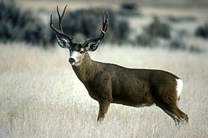
Here are some key animals and where they live:
- Bunch grass-sagebrush grasslands: mule deer, gopher snake, coyote, prairie falcon, western meadowlark, yellow-bellied marmot, kangaroo rat.
- Ponderosa-juniper brushlands: pronghorn, bobcat, scrub jay, jackrabbit, mountain bluebird.
- Pine forest: mountain lion, bald eagle (in winter), golden-mantled ground squirrel.
- Rocky lava flows: western fence lizard, western rattlesnake.
- Cave mouths and inside passages: violet-green swallow, Brazilian free-tailed bat, Townsend's big-eared bat, Pacific tree frog, pika, bushy-tailed woodrat.
- Lake shore areas: skunk, raccoon, great horned owl, short-eared owl.
History of the Lava Beds
Ancient Art at Petroglyph Point
Lava Beds National Monument is home to Petroglyph Point. This is one of the largest collections of Native American rock art in the United States. The Modoc people lived in this area for a very long time. The Lava Beds National Monument Archeological District was added to the National Register of Historic Places in 1991.
The Modoc War
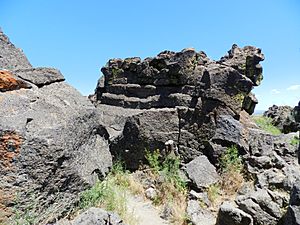
The Modoc War happened in 1872–1873. During this time, a group of Modoc warriors, led by Kintpuash (Captain Jack), used the lava beds as a strong defense. They were trying to avoid being captured. The Modoc people had been moved to a reservation in Oregon, but they wanted their original lands back.
The Modoc took shelter in a natural lava fortress. This place was later named Captain Jack's Stronghold. A small group of 53 Modoc fighting men and their families defended themselves. They held off the US Army, which had ten times more soldiers, for five months!
In April 1873, during a meeting to discuss peace, Captain Jack killed General Edward Canby. Other Modoc people also caused harm to other commissioners. The Modoc thought that if they removed the leaders, the Americans would leave. But instead, more Army soldiers arrived. The Modoc were eventually forced to give up. Kintpuash and his companions were later held responsible for their actions. They were executed at Fort Klamath.
Lava Beds Wilderness Area
The Lava Beds National Wilderness is a 28,460-acre (11,520 ha) wilderness area. It's part of the Lava Beds National Monument. The US Congress officially made it a wilderness area on October 13, 1972.
This wilderness protects more than half of the monument. It's split into two parts: an eastern and a western unit. The eastern unit has the large Schonchin lava flow. The western unit is where the Cascade Range meets the dry Modoc Plateau.
Different types of soil create many plant communities. This provides various habitats for a wide range of wildlife. You can see many coyotes and foxes here. Raptors (birds of prey) also hunt rodents like jackrabbits and kangaroo rats. Kangaroo rats are amazing because they don't need to drink water! They get all the water they need from the seeds they eat.
Many raptors are seen in the wilderness, including 24 different types of hawks. The monument is on the Pacific Flyway, a major bird migration route. The bald eagle spends its winters in the northern part of the wilderness.
The National Park Service manages the Lava Beds wilderness. They have rules to protect the area. For example, you can't camp near cave entrances or trails. Open campfires might be banned during very hot and dry weather.
Lava Beds Hiking Trails
Lava Beds National Monument has 13 hiking trails. All of them go into the backcountry. The most popular trails are short. They lead to historic sites and cool geological areas within the Lava Beds Wilderness. The longer trails are mostly in the wilderness areas.
These trails often lead to the park's main attractions. Many are easy walks with boardwalks and signs that explain what you're seeing.
| Trail name (from Visitor Center) | What you'll see | Where it starts | Length |
|---|---|---|---|
| Short trails | |||
| Bunchgrass Trail | Goes along the northeast side of Crescent Butte. | Across from Site B-7 in the campground. | 1 mi (1.6 km) |
| Missing Link Trail | Connects the Three Sisters Trail to the Bunchgrass Trail. Creates a 10 mi (16 km) loop. | On the Bunchgrass Trail, about 0.5 mi (0.80 km) from campground B-Loop. | 0.7 mi (1.1 km) |
| Heppe Ice Cave | Leads right into Heppe Cave. | On the road to Mammoth Crater, 2.2 mi (3.5 km) from the main park road. | 0.4 mi (0.64 km) |
| Big Nasty Trail | Named for a rough, brushy lava area. | Starts on Mammoth Crater rim, at the Hidden Valley pullout. | 1 mi (1.6 km) |
| Schonchin Butte Trail | A steep trail that climbs 500 feet to a lookout building. | Located on Schonchin Butte. | 0.9 mi (1.4 km) |
| Symbol Bridge Trail | Winds past interesting lava tube shapes and other cool rock features. | First parking area of Skull Cave road, across from Missing Link Trail. | Windy 0.75 mi (1.21 km) |
| Black Crater and Thomas-Wright Battlefield Trail | Mixes volcanic sights with history. Good for wildflowers in season. | Within the Thomas-Wright Battlefield memorial. | 0.3 mi (0.48 km) to the Crater, then 1.2 mi (1.9 km) |
| Gillem Bluff | Climbs to the top of Gillem Bluff for great views. It's a 550-foot climb. | Gillem Bluff. | 0.7 mi (1.1 km) |
| Captain Jack's Stronghold Trail | A rough loop trail with signs explaining the Modoc War battlefield. | Captain Jack's Stronghold 41°49′18″N 121°30′18″W / 41.82167°N 121.50500°W | Inner loop: .6 mi (0.97 km). Outer loop: 1.1 mi (1.8 km) |
| Petroglyph Point Trail | Offers amazing views of the basin and the Medicine Lake Volcano. | Northeast side of Petroglyph Point, about .3 mi (0.48 km) past the bulletin board. | 1.6 mi (2.6 km) |
| Long trails | |||
| Three Sisters Trail | Loops out into the wilderness and comes back to Skull Cave Road. | Trailhead at the campground from A-Loop. | 8.8 mi (14.2 km) |
| Lyons Trail | Crosses the wilderness from north to south. | Skull Cave parking lot. | 9.8 mi (15.8 km) |
| Whitney Butte Trail | Crosses the wilderness from east to west around Whitney Butte. Has the best views of Mount Shasta and the Callahan lava flow. | Trailhead at the Merrill Cave parking area. | 3.3 mi (5.3 km) |
Monument Gets Bigger
The monument grew in 2011 by about 132 acres. Two pieces of land were moved from other government groups to the National Park Service. These new areas are next to the Petroglyph Point Unit of the monument.
 | Sharif Bey |
 | Hale Woodruff |
 | Richmond Barthé |
 | Purvis Young |


