Tulelake, California facts for kids
Quick facts for kids
Tulelake, California
|
|
|---|---|
| City of Tulelake | |

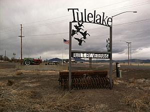
Welcome sign, south Tulelake
|
|

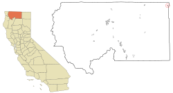
Location in Siskiyou County and the state of California
|
|
| Country | |
| State | |
| County | Siskiyou |
| Incorporated | March 1, 1937 |
| Area | |
| • Total | 0.41 sq mi (1.07 km2) |
| • Land | 0.41 sq mi (1.06 km2) |
| • Water | 0.00 sq mi (0.01 km2) 0.58% |
| Elevation | 4,035 ft (1,230 m) |
| Population
(2020)
|
|
| • Total | 902 |
| • Density | 2,200/sq mi (843/km2) |
| Time zone | UTC-8 (Pacific (PST)) |
| • Summer (DST) | UTC-7 (PDT) |
| ZIP code |
96134
|
| Area code(s) | 530 |
| FIPS code | 06-80686 |
| GNIS feature ID | 1660040 |
Tulelake (pronounced TOO-lee-layk) is a small city in the northeastern part of Siskiyou County, California. It gets its name from the nearby Tule Lake. In 2020, about 902 people lived there.
Police officers from Tulelake can also work in Malin, Oregon, which is a nearby town. This is thanks to an agreement between California and Oregon. Officers from Malin can also help out in Tulelake.
Contents
History of Tulelake
The first public sale of land in Tulelake happened on April 15, 1931. More than 100 pieces of land were sold that day. The city officially became a city in 1937. Today, Tulelake has over 400 homes.
World War II Camps Near Tulelake
During World War II, two important camps were located close to Tulelake.
- Camp Tulelake was a camp for prisoners of war. These prisoners were mainly from Italy and Germany. It was located west of town, near Sheepy Ridge.
- The Tule Lake War Relocation Center was another camp. This camp housed nearly 18,000 Japanese Americans and Japanese residents. It operated from May 1942 to March 1946. This was one of ten such camps in the United States. It was about seven miles southeast of Tulelake. Today, part of this camp area is where the town of Newell is located.
Ancient History of the Area
An ancient place called Nightfire Island is also near Tulelake. This archaeological site is over 5,000 years old. It is located west of Tule Lake, along the shores of Indian Tom Lake.
Geography and Climate
Tulelake is located close to the border between Siskiyou and Modoc Counties. It sits in the northwest part of a large area known as the Great Basin and Range.
The city covers about 0.4 square miles (1.07 square kilometers). Most of this area is land, with a very small amount of water.
Tulelake's Climate
Tulelake has a type of climate called a steppe climate. This means it is generally dry, but not as dry as a desert.
| Climate data for Tulelake, California (1991–2020 normals, extremes 1932–present) | |||||||||||||
|---|---|---|---|---|---|---|---|---|---|---|---|---|---|
| Month | Jan | Feb | Mar | Apr | May | Jun | Jul | Aug | Sep | Oct | Nov | Dec | Year |
| Record high °F (°C) | 64 (18) |
70 (21) |
77 (25) |
84 (29) |
95 (35) |
103 (39) |
102 (39) |
102 (39) |
102 (39) |
90 (32) |
75 (24) |
68 (20) |
103 (39) |
| Mean daily maximum °F (°C) | 42.4 (5.8) |
47.2 (8.4) |
53.4 (11.9) |
59.2 (15.1) |
68.9 (20.5) |
76.8 (24.9) |
86.3 (30.2) |
85.5 (29.7) |
79.0 (26.1) |
65.8 (18.8) |
49.8 (9.9) |
40.8 (4.9) |
62.9 (17.2) |
| Daily mean °F (°C) | 31.9 (−0.1) |
34.9 (1.6) |
39.6 (4.2) |
44.4 (6.9) |
53.0 (11.7) |
59.5 (15.3) |
66.8 (19.3) |
65.0 (18.3) |
58.4 (14.7) |
48.1 (8.9) |
37.4 (3.0) |
30.5 (−0.8) |
47.5 (8.6) |
| Mean daily minimum °F (°C) | 21.4 (−5.9) |
22.5 (−5.3) |
25.8 (−3.4) |
29.6 (−1.3) |
37.1 (2.8) |
42.2 (5.7) |
47.2 (8.4) |
44.4 (6.9) |
37.8 (3.2) |
30.3 (−0.9) |
25.0 (−3.9) |
20.2 (−6.6) |
32.0 (0.0) |
| Record low °F (°C) | −28 (−33) |
−24 (−31) |
−2 (−19) |
6 (−14) |
16 (−9) |
23 (−5) |
29 (−2) |
24 (−4) |
17 (−8) |
7 (−14) |
−10 (−23) |
−27 (−33) |
−28 (−33) |
| Average precipitation inches (mm) | 1.32 (34) |
1.14 (29) |
1.20 (30) |
0.99 (25) |
1.11 (28) |
0.80 (20) |
0.21 (5.3) |
0.25 (6.4) |
0.37 (9.4) |
0.72 (18) |
1.14 (29) |
1.45 (37) |
10.70 (272) |
| Average snowfall inches (cm) | 6.2 (16) |
4.0 (10) |
2.8 (7.1) |
1.6 (4.1) |
0.1 (0.25) |
0.0 (0.0) |
0.0 (0.0) |
0.0 (0.0) |
0.0 (0.0) |
0.1 (0.25) |
3.0 (7.6) |
5.0 (13) |
22.8 (58) |
| Average precipitation days (≥ 0.01 in) | 14.7 | 11.2 | 13.0 | 10.7 | 9.2 | 5.0 | 2.0 | 2.1 | 2.8 | 6.0 | 11.8 | 13.2 | 101.7 |
| Average snowy days (≥ 0.1 in) | 4.5 | 3.0 | 2.4 | 1.4 | 0.1 | 0.0 | 0.0 | 0.0 | 0.0 | 0.2 | 1.7 | 3.3 | 16.6 |
| Source: NOAA | |||||||||||||
People of Tulelake
| Historical population | |||
|---|---|---|---|
| Census | Pop. | %± | |
| 1940 | 785 | — | |
| 1950 | 1,028 | 31.0% | |
| 1960 | 950 | −7.6% | |
| 1970 | 857 | −9.8% | |
| 1980 | 783 | −8.6% | |
| 1990 | 1,010 | 29.0% | |
| 2000 | 1,020 | 1.0% | |
| 2010 | 1,010 | −1.0% | |
| 2020 | 902 | −10.7% | |
| U.S. Decennial Census | |||
As of the 2020 United States Census, Tulelake had a population of 902 people. This was a decrease from 1,010 people in 2010.
Tulelake in 2010
In 2010, the city had 1,010 people living in it. Most people lived in family homes. About 45.5% of homes had children under 18 living there. The average household had about 2.91 people.
The population was quite diverse. About 55.7% of residents were White. A large portion, 59.5%, identified as Hispanic or Latino.
The population included people of all ages. About 33.7% were under 18 years old. The median age was 29.4 years, meaning half the population was younger and half was older than that age.
Education in Tulelake
Tulelake is part of the Tulelake Basin Joint Unified School District. There are two main schools for students.
- Tulelake Elementary teaches students from preschool up to sixth grade. Their school mascot is the Gosling, which is a young goose. This mascot reflects the many waterfowl in the area.
- Tulelake High School serves students from seventh to twelfth grade. The high school mascot is the Honker, which is another name for a Canada goose.
City Infrastructure
Tulelake has its own airport, called the Tulelake Municipal Airport. This helps connect the city to other places.
See also
 In Spanish: Tulelake para niños
 | Emma Amos |
 | Edward Mitchell Bannister |
 | Larry D. Alexander |
 | Ernie Barnes |


