Malin, Oregon facts for kids
Quick facts for kids
Malin
|
||
|---|---|---|
| Malin, Oregon | ||

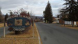
Malin city sign on Klamath Falls-Malin Highway.
|
||
|
||

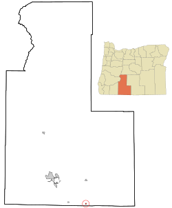
Location in Oregon
|
||
| Country | United States | |
| State | Oregon | |
| County | Klamath | |
| Incorporated | 1922 | |
| Area | ||
| • Total | 0.50 sq mi (1.29 km2) | |
| • Land | 0.50 sq mi (1.29 km2) | |
| • Water | 0.00 sq mi (0.00 km2) | |
| Elevation | 4,062 ft (1,238 m) | |
| Population
(2020)
|
||
| • Total | 731 | |
| • Density | 1,464.93/sq mi (565.36/km2) | |
| Time zone | UTC-8 (Pacific) | |
| • Summer (DST) | UTC-7 (Pacific) | |
| ZIP code |
97632
|
|
| Area code(s) | 458 and 541 | |
| FIPS code | 41-45400 | |
| GNIS feature ID | 1136509 | |
Malin is a small city located in Klamath County, Oregon, in the United States. It's a friendly place with a population of 731 people, according to the 2020 census.
Contents
The Story of Malin's Beginning
Malin was founded on September 30, 1909. About 65 families from Bohemia (a region in what is now the Czech Republic) moved here. They named the new town after their home town, Malín, which is now part of Kutná Hora. The land where Malin stands used to be the bottom of Tule Lake.
Why Malin is Special
When the first settlers arrived, they found a lot of horseradish growing. This plant became very important to Malin. Many descendants of these original Czech families still live in Malin today. They continue to farm the land their ancestors settled.
Where is Malin Located?
Malin is in the southern part of Klamath County. It's close to the border between Oregon and California. The city sits at an elevation of 4,062 feet (1,238 m) above sea level.
Nearby Places and Landmarks
Malin is found along a small road that connects to Oregon Route 39. It is southeast of Klamath Falls and east of Merrill. To the northeast is Tulelake in California. The interesting Lava Beds National Monument is also nearby, just to the south in California.
City Size
If you travel by car, Malin is about 30 miles (48 km) from Klamath Falls. It is much farther from Portland, about 309 miles (497 km) away. The city covers a total area of 0.50 square miles (1.29 km2), and all of it is land.
Malin's Weather and Climate
Malin has a climate with warm, dry summers. The average monthly temperatures do not go above 71.6 °F. This type of weather is called a warm-summer Mediterranean climate. On climate maps, you might see it labeled as "Csb". Because it's quite dry, Malin is almost considered to have a steppe climate.
| Climate data for Malin | |||||||||||||
|---|---|---|---|---|---|---|---|---|---|---|---|---|---|
| Month | Jan | Feb | Mar | Apr | May | Jun | Jul | Aug | Sep | Oct | Nov | Dec | Year |
| Record high °F (°C) | 64 (18) |
76 (24) |
76 (24) |
83 (28) |
93 (34) |
97 (36) |
102 (39) |
102 (39) |
98 (37) |
88 (31) |
74 (23) |
62 (17) |
102 (39) |
| Mean daily maximum °F (°C) | 40.7 (4.8) |
45.1 (7.3) |
49.1 (9.5) |
56.2 (13.4) |
66.1 (18.9) |
74.5 (23.6) |
82.9 (28.3) |
82.1 (27.8) |
74.5 (23.6) |
62.7 (17.1) |
47 (8) |
40.1 (4.5) |
60.1 (15.6) |
| Mean daily minimum °F (°C) | 22 (−6) |
25.3 (−3.7) |
27.3 (−2.6) |
30.8 (−0.7) |
37 (3) |
43.6 (6.4) |
48.7 (9.3) |
47.8 (8.8) |
41.8 (5.4) |
34.9 (1.6) |
27.1 (−2.7) |
21.9 (−5.6) |
34 (1) |
| Record low °F (°C) | −5 (−21) |
−18 (−28) |
−5 (−21) |
9 (−13) |
18 (−8) |
25 (−4) |
29 (−2) |
29 (−2) |
23 (−5) |
7 (−14) |
−3 (−19) |
−20 (−29) |
−20 (−29) |
| Average precipitation inches (mm) | 1.4 (36) |
1.1 (28) |
1.56 (40) |
1.06 (27) |
1.16 (29) |
0.84 (21) |
0.31 (7.9) |
0.5 (13) |
0.63 (16) |
0.99 (25) |
1.44 (37) |
1.42 (36) |
12.43 (316) |
| Average snowfall inches (cm) | 5.1 (13) |
4.7 (12) |
2.8 (7.1) |
1.5 (3.8) |
0.7 (1.8) |
0 (0) |
0 (0) |
0 (0) |
0 (0) |
0.5 (1.3) |
3.4 (8.6) |
7 (18) |
25.7 (65) |
| Average precipitation days | 8 | 7 | 9 | 7 | 6 | 4 | 2 | 2 | 3 | 5 | 9 | 9 | 71 |
Malin's Population Over Time
The number of people living in Malin has changed over the years. Here's a look at the population from different census counts.
| Historical population | |||
|---|---|---|---|
| Census | Pop. | %± | |
| 1920 | 110 | — | |
| 1930 | 215 | 95.5% | |
| 1940 | 535 | 148.8% | |
| 1950 | 592 | 10.7% | |
| 1960 | 568 | −4.1% | |
| 1970 | 486 | −14.4% | |
| 1980 | 539 | 10.9% | |
| 1990 | 725 | 34.5% | |
| 2000 | 638 | −12.0% | |
| 2010 | 805 | 26.2% | |
| 2020 | 731 | −9.2% | |
| Source: U.S. Decennial Census |
|||
A Closer Look at the 2010 Census
In 2010, Malin had 805 residents living in 255 households. Most of these households (194) were families. The city had about 1,610.0 inhabitants per square mile (621.6/km2) people per square mile.
Many different groups of people call Malin home. About 70.6% of the people were White. About 1.1% were Native American. A large part of the population, 57.8%, identified as Hispanic or Latino.
The average age in Malin was 29.1 years old. About one-third of the residents (33.3%) were under 18. Also, 10.7% of the people were 65 years or older. There were slightly more males (52.5%) than females (47.5%) in the city.
Jobs and Important Services in Malin
Malin has several important businesses that provide jobs. As of 2002, some of the biggest employers included the Circle C (a potato shed), Baley Troutman (a farm), and Cy's Market (a grocery store).
Power and Energy Connections
Malin is home to the "Malin Substation." This is a big electrical station owned by companies like PG&E and BPA. It's a key part of Path 66, which is a major power line that runs north and south.
There are also several important natural gas connections near Malin. These connections help move natural gas to different areas. For example, the Malin Interconnect links two major gas pipelines. Another connection is between the Ruby Pipeline and Pacific Gas & Electric's Redwood Path.
Getting Around Malin
The city has its own small airport, called Malin Airport.
Images for kids
See also
 In Spanish: Malin (Oregón) para niños
 | Dorothy Vaughan |
 | Charles Henry Turner |
 | Hildrus Poindexter |
 | Henry Cecil McBay |


