
Merrill, Oregon facts for kids
Quick facts for kids
Merrill
|
|
|---|---|
| Merrill, Oregon | |
 |
|

Location in Oregon
|
|
| Country | United States |
| State | Oregon |
| County | Klamath |
| Incorporated | 1903 |
| Area | |
| • Total | 0.46 sq mi (1.19 km2) |
| • Land | 0.46 sq mi (1.19 km2) |
| • Water | 0.00 sq mi (0.00 km2) |
| Elevation | 4,071 ft (1,241 m) |
| Population
(2020)
|
|
| • Total | 821 |
| • Density | 1,788.67/sq mi (690.66/km2) |
| Time zone | UTC-8 (Pacific) |
| • Summer (DST) | UTC-7 (Pacific) |
| ZIP code |
97633
|
| Area code(s) | 541 |
| FIPS code | 41-47700 |
| GNIS feature ID | 1124069 |
Merrill is a small city in Klamath County, Oregon, United States. In 2020, about 821 people lived there.
Merrill is known for its farms and holds an exciting annual Potato Festival. The area is also part of the Klamath Basin, where people have worked to manage water for farms, local tribes, and wildlife.
This city is special because it was the birthplace of Carl Barks. He was a famous Disney comics artist who created characters like Scrooge McDuck. Merrill is also home to the Raiders sports teams from Lost River Jr./Sr. High School.
Contents
Exploring Merrill's Location
Merrill is located in the southern part of Klamath County. It is close to the border between Oregon and California. The city sits at an elevation of about 4,071 feet (1,241 m) above sea level.
Rivers and Lakes Near Merrill
You can find Merrill along Oregon Route 39. It is southeast of Klamath Falls and northwest of Tulelake. Two lakes, Lower Klamath Lake and Tule Lake, are just south of Merrill in California. The Lost River also flows right by the city.
Mountains and Travel Distances
From Merrill, you can see Mount Shasta. This tall mountain is part of the Cascade Range and is southwest of the city. By car, Merrill is about 20 miles (32 km) from Klamath Falls. It is also about 300 miles (480 km) from Portland. The city itself covers about 0.46 square miles (1.19 km2) of land.
Merrill's Climate and Weather
Merrill has a climate with warm, dry summers. The average monthly temperatures do not go above 71.6 °F (22 °C). This type of weather is called a warm-summer Mediterranean climate. On climate maps, it is often shown as "Csb."
Merrill's Early History
The city of Merrill was named after a rancher named Nathan S. Merrill. He settled in this area in 1890. A post office was opened in Merrill in 1896, and H. E. Momyre was the first postmaster. The very first business in Merrill was a grist mill, which is a place that grinds grain into flour.
Merrill's Local Economy
Merrill's economy is mostly based on farming. In 2002, some of the biggest employers in the city included the Malin Potato Coop and the Merrill Grain and Feed Center. Other important businesses were the Klamath County School District, the Martin Food Center, and Country Boy Meats. These businesses provide many jobs for the people living in Merrill.
Merrill's Population Over Time
| Historical population | |||
|---|---|---|---|
| Census | Pop. | %± | |
| 1900 | 67 | — | |
| 1910 | 400 | 497.0% | |
| 1920 | 237 | −40.7% | |
| 1930 | 306 | 29.1% | |
| 1940 | 648 | 111.8% | |
| 1950 | 835 | 28.9% | |
| 1960 | 804 | −3.7% | |
| 1970 | 722 | −10.2% | |
| 1980 | 809 | 12.0% | |
| 1990 | 837 | 3.5% | |
| 2000 | 897 | 7.2% | |
| 2010 | 844 | −5.9% | |
| 2020 | 821 | −2.7% | |
| Source: U.S. Decennial Census |
|||
The population of Merrill has changed over the years. In 2010, there were 844 people living in the city. The city had 308 households, and 221 of them were families. The population density was about 1,834.8 inhabitants per square mile (708.4/km2) people per square mile.
Many different groups of people live in Merrill. In 2010, about 70.9% of the people were White. About 23.8% were from other races, and 3.7% were from two or more races. A large part of the population, 43.1%, identified as Hispanic or Latino.
The average age of people in Merrill in 2010 was 35.7 years old. About 29% of the residents were under 18 years old. About 12.6% were 65 years old or older. The city had a nearly even split between males (50.7%) and females (49.3%).
Images for kids
-
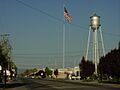
A view of Merrill, Oregon.
-
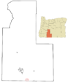
Map showing Merrill's location in Klamath County, Oregon.
See also
 In Spanish: Merrill (Oregón) para niños
