Chickasaw County, Iowa facts for kids
Quick facts for kids
Chickasaw County
|
|
|---|---|

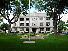
Chickasaw County court house built in 1929
|
|

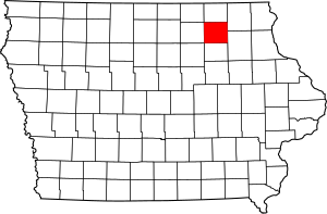
Location within the U.S. state of Iowa
|
|
 Iowa's location within the U.S. |
|
| Country | |
| State | |
| Founded | January 15, 1851 |
| Named for | Chickasaw people |
| Seat | New Hampton |
| Largest city | New Hampton |
| Area | |
| • Total | 506 sq mi (1,310 km2) |
| • Land | 504 sq mi (1,310 km2) |
| • Water | 1.3 sq mi (3 km2) 0.3% |
| Population
(2020)
|
|
| • Total | 12,012 |
| • Density | 23.739/sq mi (9.166/km2) |
| Time zone | UTC−6 (Central) |
| • Summer (DST) | UTC−5 (CDT) |
| Congressional district | 2nd |
Chickasaw County is a county in the state of Iowa, USA. In 2020, about 12,012 people lived there. The main town, or county seat, is New Hampton. The county got its name from the Chickasaw people, a Native American group from the southern United States.
Contents
History of Chickasaw County
Chickasaw County was started in January 1851. It was named after the Chickasaw tribe. This tribe lived in the Southern United States at that time.
The first non-Native American settlers came in 1848. The first county seat was in Bradford, starting in 1854. In 1857, the county seat moved to New Hampton. This new location was closer to the center of the county.
At first, county offices were in private homes and the local school. The first courthouse was a wooden building built in 1865. It was made bigger in 1876. But a fire destroyed it on March 26, 1880. Luckily, people saved the important records. A new building made of brick and stone was finished in 1881. It had a tall clock tower. This building was also made bigger in 1905 and 1906. However, by the 1920s, it was too small again. The current courthouse, made of Bedford stone, was built in 1929 and opened in 1930.
Geography of Chickasaw County
Chickasaw County covers about 506 square miles (1,311 square kilometers). Most of this area is land. Only a small part, about 1.3 square miles, is water.
Neighboring Counties
Chickasaw County shares borders with these other counties:
- Bremer County (to the south)
- Butler County (to the southwest)
- Fayette County (to the southeast)
- Floyd County (to the west)
- Howard County (to the north)
- Mitchell County (to the northwest)
- Winneshiek County (to the northeast)
Main Highways in the County
Several important roads pass through Chickasaw County:
Population and People
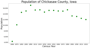
| Historical population | |||
|---|---|---|---|
| Census | Pop. | %± | |
| 1860 | 4,336 | — | |
| 1870 | 10,180 | 134.8% | |
| 1880 | 14,534 | 42.8% | |
| 1890 | 15,019 | 3.3% | |
| 1900 | 17,037 | 13.4% | |
| 1910 | 15,375 | −9.8% | |
| 1920 | 15,431 | 0.4% | |
| 1930 | 14,637 | −5.1% | |
| 1940 | 15,227 | 4.0% | |
| 1950 | 15,228 | 0.0% | |
| 1960 | 15,034 | −1.3% | |
| 1970 | 14,969 | −0.4% | |
| 1980 | 15,437 | 3.1% | |
| 1990 | 13,295 | −13.9% | |
| 2000 | 13,095 | −1.5% | |
| 2010 | 12,439 | −5.0% | |
| 2020 | 12,012 | −3.4% | |
| 2023 (est.) | 11,658 | −6.3% | |
| U.S. Decennial Census 1790-1960 1900-1990 1990-2000 2010-2018 |
|||
2020 Census Information
In 2020, the census counted 12,012 people living in Chickasaw County. This means there were about 24 people for every square mile. Most people (96.29%) said they belonged to one race. About 89.67% were non-Hispanic White. Other groups included Black people (0.67%), Hispanic people (4.00%), Native Americans (0.17%), and Asian people (0.25%). A small number were Native Hawaiian or Pacific Islander (0.06%). About 5.18% were of another race or more than one race. There were 5,534 homes, and 5,022 of them were lived in.
2010 Census Information
The 2010 census showed that 12,439 people lived in the county. There were 5,679 homes, and 5,204 of them were occupied.
Towns and Communities
Chickasaw County has several cities and smaller communities.
Cities in Chickasaw County
Smaller Unincorporated Communities
These places are not officially cities or towns:
Townships in the County
A township is a small area within a county. Chickasaw County has these townships:
- Bradford
- Chickasaw
- Dayton
- Deerfield
- Dresden
- Fredericksburg
- Jacksonville
- New Hampton
- Richland
- Stapleton
- Utica
- Washington
Population Ranking of Cities (2020)
This table shows the cities in Chickasaw County from largest to smallest by population in 2020.
† means it is the county seat
| Rank | City/Town/etc. | Type | Population (2020 Census) |
|---|---|---|---|
| 1 | † New Hampton | City | 3,494 |
| 2 | Nashua (partly in Floyd County) | City | 1,551 |
| 3 | Fredericksburg | City | 987 |
| 4 | Lawler | City | 406 |
| 5 | Ionia | City | 226 |
| 6 | Protivin (mostly in Howard County) | City | 269 |
| 7 | Alta Vista | City | 227 |
| 8 | North Washington | City | 112 |
| 9 | Bassett | City | 45 |
See also
 In Spanish: Condado de Chickasaw (Iowa) para niños
 | Shirley Ann Jackson |
 | Garett Morgan |
 | J. Ernest Wilkins Jr. |
 | Elijah McCoy |


