Butler County, Iowa facts for kids
Quick facts for kids
Butler County
|
|
|---|---|

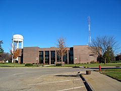
Butler County Courthouse
|
|

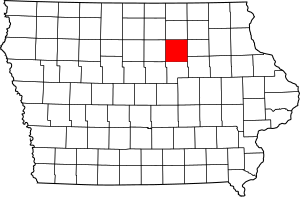
Location within the U.S. state of Iowa
|
|
 Iowa's location within the U.S. |
|
| Country | |
| State | |
| Founded | 1851 |
| Named for | William Orlando Butler |
| Seat | Allison |
| Largest city | Parkersburg |
| Area | |
| • Total | 582 sq mi (1,510 km2) |
| • Land | 580 sq mi (1,500 km2) |
| • Water | 1.6 sq mi (4 km2) 0.3% |
| Population
(2020)
|
|
| • Total | 14,334 |
| • Density | 24.629/sq mi (9.509/km2) |
| Time zone | UTC−6 (Central) |
| • Summer (DST) | UTC−5 (CDT) |
| Congressional district | 4th |
Butler County is a county located in the state of Iowa, in the United States. As of the 2020 census, about 14,334 people lived there. Its main town, or county seat, is Allison. The county was officially formed in 1854. It was named after General William O. Butler.
Contents
History of Butler County
Butler County was created on January 15, 1851. It was named after William Orlando Butler. He was a general and a hero from the Mexican-American War. He also ran for Vice President of the United States in 1848.
Until 1854, other counties managed Butler County. Then, enough people lived there to start their own local government. The first court meetings happened in a small log cabin. In 1858, the first courthouse was finished in Clarksville. Later, it was sold and used as a school from 1863 to 1903.
Clarksville was the first county seat from 1854 to 1860. After that, Butler Center became the county seat. People were not happy with Butler Center. It was hard to reach, especially in winter. So, Allison became the county seat on January 10, 1881. This happened after new train tracks were built there.
Butler County is unique in Iowa. It does not have any four-lane roads or major highways. There is also no hospital or movie theater. You won't find any national fast-food chains here either. It is also one of the only counties in Iowa without a stoplight.
Geography of Butler County
The U.S. Census Bureau says the county covers about 582 square miles. Most of this area, about 580 square miles, is land. The rest, about 1.6 square miles, is water.
Main Roads in Butler County
Neighboring Counties
Butler County shares borders with these other counties:
- Floyd County (north)
- Bremer County (east)
- Black Hawk County (southeast)
- Grundy County (south)
- Franklin County (west)
- Chickasaw County (northeast)
- Cerro Gordo County (northwest)
- Hardin County (southwest)
Population of Butler County
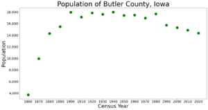
| Historical population | |||
|---|---|---|---|
| Census | Pop. | %± | |
| 1860 | 3,724 | — | |
| 1870 | 9,951 | 167.2% | |
| 1880 | 14,293 | 43.6% | |
| 1890 | 15,463 | 8.2% | |
| 1900 | 17,955 | 16.1% | |
| 1910 | 17,119 | −4.7% | |
| 1920 | 17,845 | 4.2% | |
| 1930 | 17,617 | −1.3% | |
| 1940 | 17,986 | 2.1% | |
| 1950 | 17,394 | −3.3% | |
| 1960 | 17,467 | 0.4% | |
| 1970 | 16,953 | −2.9% | |
| 1980 | 17,668 | 4.2% | |
| 1990 | 15,731 | −11.0% | |
| 2000 | 15,305 | −2.7% | |
| 2010 | 14,867 | −2.9% | |
| 2020 | 14,334 | −3.6% | |
| 2023 (est.) | 14,172 | −4.7% | |
| U.S. Decennial Census 1790-1960 1900-1990 1990-2000 2010-2018 |
|||
2020 Census Information
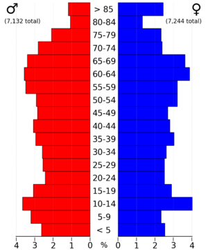
The 2020 census counted 14,334 people living in Butler County. This means there were about 24 people per square mile. Most people, about 97.49%, said they belonged to one race. About 95.19% were non-Hispanic White. Other groups included Black, Hispanic, Native American, and Asian people. There were 6,536 homes in the county, and 5,992 of them were lived in.
Communities in Butler County
Butler County has several cities and smaller communities.
Cities in Butler County
Smaller Communities (Unincorporated)
These places are not officially cities or towns:
- Austinville
- Kesley
- Packard
Townships in Butler County
Butler County is divided into sixteen areas called townships:
- Albion
- Beaver
- Bennezette
- Butler
- Coldwater
- Dayton
- Fremont
- Jackson
- Jefferson
- Madison
- Monroe
- Pittsford
- Ripley
- Shell Rock
- Washington
- West Point
City Populations (2020 Census)
This table shows how many people lived in each city in Butler County in 2020. † county seat
| Rank | City/Town/etc. | Municipal type | Population (2020 Census) |
|---|---|---|---|
| 1 | Parkersburg | City | 2,015 |
| 2 | Shell Rock | City | 1,268 |
| 3 | Clarksville | City | 1,264 |
| 4 | Aplington | City | 1,116 |
| 5 | Greene (partially in Floyd County) | City | 990 |
| 6 | † Allison | City | 966 |
| 7 | Dumont | City | 634 |
| 8 | New Hartford | City | 570 |
| 9 | Bristow | City | 145 |
| 10 | Aredale | City | 62 |
See also
 In Spanish: Condado de Butler (Iowa) para niños
 | James Van Der Zee |
 | Alma Thomas |
 | Ellis Wilson |
 | Margaret Taylor-Burroughs |


