Parkersburg, Iowa facts for kids
Quick facts for kids
Parkersburg, Iowa
|
|
|---|---|

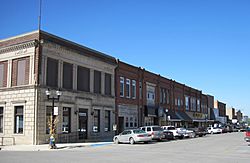
Downtown Parkersburg
|
|

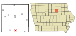
Location of Parkersburg, Iowa
|
|
| Country | |
| State | |
| County | Butler |
| Incorporated | December 7, 1874 |
| Area | |
| • Total | 1.44 sq mi (3.74 km2) |
| • Land | 1.44 sq mi (3.74 km2) |
| • Water | 0.00 sq mi (0.00 km2) |
| Elevation | 971 ft (296 m) |
| Population
(2020)
|
|
| • Total | 2,015 |
| • Density | 1,396.40/sq mi (539.21/km2) |
| Time zone | UTC-6 (Central (CST)) |
| • Summer (DST) | UTC-5 (CDT) |
| ZIP code |
50665
|
| Area code(s) | 319 |
| FIPS code | 19-61590 |
| GNIS feature ID | 0460029 |
Parkersburg is a friendly city located in Butler County, Iowa. In 2020, about 2,015 people lived here. Even though it's not the main county town, Parkersburg is the biggest city in Butler County!
Contents
A Look Back: Parkersburg's History
The first settlers arrived in Parkersburg around 1857. John Connell and his son William built the very first log cabin. Railroad companies explored the area in the early 1860s. A train station was built in 1865. Soon, two major railroads, the Illinois Central and the Chicago North Western, passed through the town.
The town was officially named "Parkersburg" to honor Pascal P. Parker. He was an important early settler and the town's first postmaster. The first big business was a hotel called The Williams House, built by Thomas Williams. Parkersburg officially became a city on December 7, 1874.
School Days in Parkersburg
The first "School House" was built in the 1860s. Parkersburg became its own school district in 1871. A new school building was constructed in 1872. Sadly, this building burned down in a big fire on October 9, 1893. This fire also destroyed most of the town's business area. In 1894, a new, modern brick school was built. In 1930, the school added a cool auditorium and a gym.
Modernizing the Town
The first electric power came to Parkersburg in 1898. A local company built the power plant. Around 1920, the roads in Parkersburg were paved. The town's first water tower could hold 40,000 gallons of water.
The 2008 Tornado: A Story of Strength
On May 25, 2008, a very powerful tornado hit Parkersburg. It was an EF5 tornado, which is the strongest kind. Seven people in Parkersburg and two in nearby New Hartford sadly passed away. Many others were hurt.
The tornado completely destroyed the south side of Parkersburg. Over 400 homes were ruined or damaged. The high school lost its roof, and the elementary school was also damaged. Everyone who survived had to leave the town while rescue teams worked. Today, Parkersburg is known as a great example of how a community can recover and rebuild after a natural disaster. The local water company got help from the Iowa Rural Water Association to fix water connections after the storm.
Where is Parkersburg? Geography Facts
Parkersburg is located at 42.574419 degrees north latitude and -92.786729 degrees west longitude. The city covers about 1.42 square miles (3.74 square kilometers) of land. There is no water area within the city limits.
Who Lives in Parkersburg? Population Details
| Historical population | |||
|---|---|---|---|
| Census | Pop. | %± | |
| 1880 | 652 | — | |
| 1890 | 760 | 16.6% | |
| 1900 | 1,164 | 53.2% | |
| 1910 | 938 | −19.4% | |
| 1920 | 1,108 | 18.1% | |
| 1930 | 1,046 | −5.6% | |
| 1940 | 1,260 | 20.5% | |
| 1950 | 1,300 | 3.2% | |
| 1960 | 1,468 | 12.9% | |
| 1970 | 1,631 | 11.1% | |
| 1980 | 1,968 | 20.7% | |
| 1990 | 1,804 | −8.3% | |
| 2000 | 1,889 | 4.7% | |
| 2010 | 1,870 | −1.0% | |
| 2020 | 2,015 | 7.8% | |
| U.S. Decennial Census | |||
Parkersburg in 2020
In 2020, there were 2,015 people living in Parkersburg. There were 858 households and 565 families. The city had about 1,396 people per square mile. Most people (96.1%) were White. About 1.2% of the population was Hispanic or Latino.
The average age in the city was 41.6 years old. About 26.8% of the people were under 20 years old. 22.3% were 65 years or older. There were slightly more females (51.2%) than males (48.8%).
Fun and Games: Parks and Recreation
Parkersburg has many great places for outdoor fun!
- Miracle Park: This park is on the west side of town. It has two big playground areas, one for younger kids (ages 2-5) and one for older kids (ages 5-12). Miracle Park also has an outdoor swimming pool, three picnic shelters, basketball courts, and a special Veterans Memorial built in 2010.
- Schwartz Memorial Park: Located on the east side, this park has a playground, a gazebo for shelter, a walking path, and a small fishing pond for kids.
- The Depot Park: This park is on the north side of Parkersburg, next to Beaver Creek. It has a shelter, a historic train depot and caboose, playground equipment, and lots of space for fishing.
- Beaver Meadows Golf Course and Campground: Right next to Depot Park, this area has a nine-hole golf course.
- Legend Trail Golf Course: On the east side of Parkersburg, this is another nine-hole golf course. It has a large clubhouse for events like weddings and graduations, plus a driving range and a walking path. It's also close to Schwartz Memorial Park.
- The Big Marsh Wildlife Management Area: This is Iowa's largest area of timber, wetlands, and grasslands. It covers over 5,800 acres! It's a fantastic place for public hunting, fishing, bird watching, and hiking. You can find The Big Marsh six miles north of Parkersburg on Highway 14.
Learning in Parkersburg: Education
Students in Parkersburg attend schools in the Aplington–Parkersburg Community School District. This district was formed in 2004 when the Aplington and Parkersburg school districts joined together. The high school is Aplington–Parkersburg High School.
Getting Around: Transportation
Parkersburg is easy to reach! It's located where Iowa Highway 14 and Iowa Highway 57 meet. It's also just north of U.S. Route 20 at exit 208.
Famous Faces from Parkersburg
Many notable people have connections to Parkersburg:
- Pauline Pfeiffer: The second wife of famous author Ernest Hemingway.
- Roy Luebbe: A Major League Baseball catcher who played for the New York Yankees.
- William Wallace McCredie: A member of the United States House of Representatives from Washington.
- Harold Duane Vietor: A federal judge.
- Brad Meester: A former center for the Jacksonville Jaguars in the NFL.
- Casey Wiegmann: A former center for the Kansas City Chiefs and Denver Broncos in the NFL.
- Major General John B. Anderson: A United States Army officer who served in both World War I and World War II.
Sister Cities
Parkersburg, Iowa, has a sister city:
See also
 In Spanish: Parkersburg (Iowa) para niños
 | Emma Amos |
 | Edward Mitchell Bannister |
 | Larry D. Alexander |
 | Ernie Barnes |


