
Parkersburg, West Virginia facts for kids
Quick facts for kids
Parkersburg, West Virginia
|
|||
|---|---|---|---|

Downtown Parkersburg as viewed from Fort Boreman Historical Park in 2006
|
|||
|
|||
| Nickname(s):
The Burg, P-Burg, PKB, The Savings Bond Capital of America, Marble Capital of the World
|
|||
| Motto(s):
Where West Virginia Began
|
|||

Location of Parkersburg in Wood County, West Virginia
|
|||

Parkersburg, West Virginia
Location in West Virginia

Parkersburg, West Virginia
Location in the United States
|
|||
| Country | United States | ||
| State | West Virginia | ||
| County | Wood | ||
| Incorporated | 1810 | ||
| Area | |||
| • City | 12.33 sq mi (31.94 km2) | ||
| • Land | 11.78 sq mi (30.52 km2) | ||
| • Water | 0.55 sq mi (1.43 km2) 4.29% | ||
| Elevation | 633 ft (193 m) | ||
| Population
(2020)
|
|||
| • City | 29,749 | ||
| • Estimate
(2021)
|
29,403 | ||
| • Density | 2,487/sq mi (960/km2) | ||
| • Metro | 92,082 (US: 365th) | ||
| Time zone | UTC−5 (EST) | ||
| • Summer (DST) | UTC−4 (EDT) | ||
| ZIP codes |
26101, 26102, 26103, 26104, 26105, 26106
|
||
| Area code(s) | 304, 681 | ||
| FIPS code | 54-62140 | ||
| GNIS feature ID | 2390632 | ||


Parkersburg is a city in West Virginia, United States. It is the main city of Wood County. The city is located where the Ohio and Little Kanawha rivers meet. It is the fourth-largest city in West Virginia. In 2020, about 29,749 people lived there. The larger area around the city, called the metropolitan area, had about 89,490 people. Parkersburg is about 14 miles (23 km) south of Marietta, Ohio.
Contents
History
How Parkersburg Began

In the late 1700s, settlers first called this area Newport. These settlers moved west after the American Revolutionary War. A part of the town was planned on land given to Alexander Parker. He received this land for his service in the Revolutionary War. In 1809, it was decided that Parker's family owned the land. So, in 1810, the town was renamed Parkersburg. It officially became a town in 1820 and a city in 1860.
Transportation and Growth
Parkersburg was an important stop for travelers. It was the end point for two major roads: the Staunton-Parkersburg Turnpike and the Northwestern Turnpike. In 1857, the Baltimore and Ohio Railroad built a train line to the city. This helped connect Parkersburg to other places.
Later, a large railroad bridge was built between Parkersburg and Belpre, Ohio. This bridge, finished in 1870, connected the city to a main train line. It helped Parkersburg become a busy center for trade. Today, this bridge is known as the Parkersburg Bridge.
During the American Civil War, Parkersburg was a key place for Union forces. It was used for transportation and medical care. After the war, the city grew even more because of the oil and gas industry.
Oil and Industry
In the late 1800s, Parkersburg became a major center for refining oil. Oil fields nearby, like Volcano and Burning Springs, supplied the oil. The Camden Consolidated Oil Company was a big player in this business. It was later sold to Rockefeller's Standard Oil Company in 1875.
After World War II, Parkersburg became a leading industrial city. It produced many things like chemicals, glass, tools, and textiles. In 1954, the Bureau of the Public Debt, a U.S. government agency, moved to Parkersburg. This was done to keep it safe in case of a national emergency. In 2012, this agency became part of the Bureau of the Fiscal Service.
Geography
Location and Rivers
Parkersburg is located at 39°15'58" North and 81°32'32" West. The city covers about 12.35 square miles (31.99 km2). Most of this area is land, with a small part being water.
The city sits where the Little Kanawha River and the Ohio River meet. The Little Kanawha River divides the city into northern and southern parts. Worthington Creek also flows through the eastern side of the city.
Neighborhoods
Parkersburg has many neighborhoods. The North End includes areas like Downtown, Julia-Ann Square, and Riverside. South Parkersburg used to be a separate city. It became part of Parkersburg in 1950. Other nearby areas include Blennerhassett, Lubeck, and Washington.
Climate
Parkersburg has a climate with hot, humid summers and cold winters. Rain and snow are spread out throughout the year. The city's climate is known as a humid continental climate.
| Climate data for Parkersburg Airport, West Virginia (1991–2020 normals, extremes 1926–present) | |||||||||||||
|---|---|---|---|---|---|---|---|---|---|---|---|---|---|
| Month | Jan | Feb | Mar | Apr | May | Jun | Jul | Aug | Sep | Oct | Nov | Dec | Year |
| Record high °F (°C) | 78 (26) |
79 (26) |
89 (32) |
91 (33) |
95 (35) |
100 (38) |
104 (40) |
102 (39) |
102 (39) |
96 (36) |
86 (30) |
78 (26) |
104 (40) |
| Mean maximum °F (°C) | 65 (18) |
67 (19) |
76 (24) |
84 (29) |
88 (31) |
91 (33) |
93 (34) |
93 (34) |
90 (32) |
83 (28) |
75 (24) |
66 (19) |
94 (34) |
| Mean daily maximum °F (°C) | 40.2 (4.6) |
44.4 (6.9) |
54.2 (12.3) |
66.9 (19.4) |
74.9 (23.8) |
82.1 (27.8) |
85.3 (29.6) |
84.7 (29.3) |
78.5 (25.8) |
66.8 (19.3) |
54.8 (12.7) |
44.4 (6.9) |
64.8 (18.2) |
| Daily mean °F (°C) | 32.0 (0.0) |
35.0 (1.7) |
43.6 (6.4) |
54.6 (12.6) |
63.3 (17.4) |
71.0 (21.7) |
74.7 (23.7) |
73.5 (23.1) |
66.9 (19.4) |
55.4 (13.0) |
44.7 (7.1) |
36.3 (2.4) |
54.2 (12.3) |
| Mean daily minimum °F (°C) | 23.7 (−4.6) |
25.7 (−3.5) |
32.9 (0.5) |
42.4 (5.8) |
51.6 (10.9) |
59.9 (15.5) |
64.1 (17.8) |
62.4 (16.9) |
55.2 (12.9) |
43.9 (6.6) |
34.6 (1.4) |
28.3 (−2.1) |
43.7 (6.5) |
| Mean minimum °F (°C) | 2 (−17) |
5 (−15) |
14 (−10) |
26 (−3) |
34 (1) |
47 (8) |
54 (12) |
52 (11) |
41 (5) |
29 (−2) |
19 (−7) |
10 (−12) |
−1 (−18) |
| Record low °F (°C) | −24 (−31) |
−10 (−23) |
−3 (−19) |
18 (−8) |
28 (−2) |
36 (2) |
44 (7) |
40 (4) |
32 (0) |
21 (−6) |
4 (−16) |
— | −24 (−31) |
| Average precipitation inches (mm) | 3.27 (83) |
3.11 (79) |
3.67 (93) |
3.62 (92) |
4.17 (106) |
4.44 (113) |
4.45 (113) |
3.38 (86) |
3.18 (81) |
2.98 (76) |
2.88 (73) |
3.36 (85) |
42.51 (1,080) |
| Average snowfall inches (cm) | 7.9 (20) |
5.5 (14) |
4.2 (11) |
0.9 (2.3) |
0.0 (0.0) |
0.0 (0.0) |
0.0 (0.0) |
0.0 (0.0) |
0.0 (0.0) |
0.0 (0.0) |
0.8 (2.0) |
2.8 (7.1) |
22.1 (56) |
| Average precipitation days (≥ 0.01 in) | 14.5 | 12.2 | 13.4 | 13.2 | 13.2 | 11.4 | 12.1 | 9.8 | 8.8 | 11.5 | 10.7 | 13.2 | 144.0 |
| Average snowy days (≥ 0.1 in) | 6.7 | 4.9 | 2.8 | 0.5 | 0.0 | 0.0 | 0.0 | 0.0 | 0.0 | 0.1 | 1.1 | 4.3 | 20.4 |
| Mean monthly sunshine hours | 115.5 | 131.0 | 182.3 | 208.1 | 248.0 | 257.3 | 255.0 | 245.2 | 212.5 | 193.9 | 117.1 | 93.4 | 2,259.3 |
| Percent possible sunshine | 38 | 44 | 49 | 52 | 56 | 58 | 56 | 58 | 57 | 56 | 39 | 32 | 51 |
| Source: NOAA (snow 1981–2010, sun 1961–1990) | |||||||||||||
People in Parkersburg
| Historical population | |||
|---|---|---|---|
| Census | Pop. | %± | |
| 1850 | 1,218 | — | |
| 1860 | 2,493 | 104.7% | |
| 1870 | 5,546 | 122.5% | |
| 1880 | 6,582 | 18.7% | |
| 1890 | 8,408 | 27.7% | |
| 1900 | 11,703 | 39.2% | |
| 1910 | 17,842 | 52.5% | |
| 1920 | 20,050 | 12.4% | |
| 1930 | 29,623 | 47.7% | |
| 1940 | 30,103 | 1.6% | |
| 1950 | 29,684 | −1.4% | |
| 1960 | 44,797 | 50.9% | |
| 1970 | 44,208 | −1.3% | |
| 1980 | 39,946 | −9.6% | |
| 1990 | 33,862 | −15.2% | |
| 2000 | 33,099 | −2.3% | |
| 2010 | 31,492 | −4.9% | |
| 2020 | 29,749 | −5.5% | |
| U.S. Decennial Census | |||
Population in 2020
In 2020, Parkersburg had 29,749 people living there. There were 13,119 households, which are groups of people living together. The city had about 2,524 people per square mile (1,029/km2).
Most people in the city, about 93.8%, were White. About 1.9% were African American, and 0.9% were Asian. People of Hispanic or Latino background made up 1.5% of the population.
About 24.9% of households had children under 18. The average age in the city was 42 years old. About 20.5% of residents were under 18, and 21.6% were 65 or older.
Fun Things to Do
Events and Festivals
Parkersburg hosts several fun events each year:
- The Annual Mid-Ohio Valley Multi-Cultural Festival happens in June. It celebrates different cultures with dance, music, and an international market.
- The Parkersburg Homecoming Festival is in August. It includes a parade, fireworks, a half-marathon, and entertainment.
- The Taste of Parkersburg is held around Memorial Day. It features delicious food and drinks from local restaurants.
- The Downtown Throwdown is a BBQ and beer festival in September.
Places to Visit
There are many interesting museums in Parkersburg:
- The Blennerhassett Museum of Regional History
- The Henry Cooper House
- The Oil and Gas Museum
- The Sumnerite African-American History Museum
- The Artcraft Studio
- The Veterans Museum of Mid-Ohio Valley
Parks and Recreation
Parkersburg has many parks where you can enjoy the outdoors:
- Blennerhassett Island Historical State Park
- Bicentennial Park
- City Park
- Fort Boreman Historical Park
- Point Park
- Southwood Park
Sports

Parkersburg has a strong sports history. The Wood County Ravens were a semi-professional football team here. The city also had a minor league baseball team called the Ohio Valley Redcoats from 1993 to 1998.
In 2008, Parkersburg and its three high schools placed second in ESPN's "TitleTown USA" competition. This was because the city's high school sports teams had won 192 state championships!
Environment
Parkersburg has worked to address environmental concerns. In the past, there were discussions about water quality due to certain substances from industrial sites. Steps have been taken to ensure the safety of the drinking water for the community.
Education
Colleges and Universities
- West Virginia University at Parkersburg is a public college located just outside the city.
- Parkersburg Bible College is a private Christian school.
- Centurion Bible College is also a private school.
Schools for Kids
Parkersburg is home to three high schools:
- Parkersburg High School (the Big Reds)
- Parkersburg South High School (the Patriots)
- Parkersburg Catholic High School (the Crusaders)
The city also has the Wood County Technical Center and the Caperton Center for Applied Technology. As of 2020, there were five middle schools and 16 elementary schools in the city.
Media
Parkersburg has its own local news. The Parkersburg News and Sentinel is the city's daily newspaper. It was formed in 2009 when two older newspapers combined.
There are many radio stations that broadcast from Parkersburg, including:
- 106.1 Z106 (WRZZ)
- 102.1 The River (WRVB)
- U.S. 107 WNUS
- MIX 100 (WDMX)
- V96.9 (WVVV)
- WPKM 96.3 FM "the Beat" (the college radio station for WVU at Parkersburg)
For television, WTAP is the main local station. WIYE-LD and WOVA-LD are also local TV stations.
Transportation

Parkersburg is served by two major highways: Interstate 77 and US 50. Other important roads include WV routes 2, 14, 47, 68, 95, and 618.
The city has an airport called Mid-Ohio Valley Regional Airport. It offers flights to Charlotte Douglas International Airport.
In the past, passenger trains stopped in Parkersburg. Today, freight trains still use the rail lines.
Famous People from Parkersburg
- Allen Appel, novelist
- Walt Barnes, football player and actor
- Edwin Catmull, president of Pixar Animation Studios
- Paul Dooley, Hollywood actor
- Linda Goodman, astrology author
- Dick Hoblitzel, baseball player
- John D. Hoblitzell Jr., U.S. Senator
- Jacob B. Jackson, Governor of West Virginia
- Leon Claire Metz, historian and author
- Earle "Greasy" Neale, football and baseball player
- Nick Swisher, professional baseball player
- Steve Swisher, professional baseball player
- Peter G. Van Winkle, U.S. Senator
- Deron Williams, professional basketball player
Sister City
Parkersburg has one sister city:
Images for kids
-

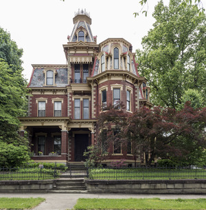
The Chancellor House in the Julia-Ann Square Historic District.
See also
 In Spanish: Parkersburg (Virginia Occidental) para niños
