Hardin County, Iowa facts for kids
Quick facts for kids
Hardin County
|
|
|---|---|

|
|

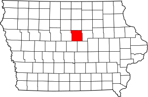
Location within the U.S. state of Iowa
|
|
 Iowa's location within the U.S. |
|
| Country | |
| State | |
| Founded | 1851 |
| Named for | John J. Hardin |
| Seat | Eldora |
| Largest city | Iowa Falls |
| Area | |
| • Total | 570 sq mi (1,500 km2) |
| • Land | 569 sq mi (1,470 km2) |
| • Water | 0.7 sq mi (2 km2) 0.1% |
| Population
(2020)
|
|
| • Total | 16,878 |
| • Estimate
(2023)
|
16,463 |
| • Density | 29.61/sq mi (11.43/km2) |
| Time zone | UTC−6 (Central) |
| • Summer (DST) | UTC−5 (CDT) |
| Congressional district | 2nd |
Hardin County is a special area in the state of Iowa, USA. It's like a big neighborhood with its own local government. In 2020, about 16,878 people lived here. The main town, or "county seat," where the government offices are, is Eldora. The county was named after Colonel John J. Hardin, an important person from Illinois who bravely fought in the Mexican–American War.
Contents
History of Hardin County
Hardin County was officially created in 1851. It got its name from Colonel John J. Hardin, who was a hero in the Mexican–American War.
Over the years, Hardin County has had three different courthouses. The first one was a small building made of wood. Sadly, it burned down in the 1850s. The second courthouse was a two-story building. It stood where the county sheriff's office is today.
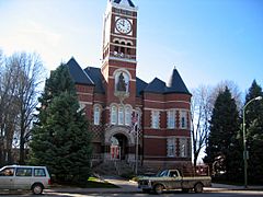
The third and current courthouse was built in 1892. It opened its doors on September 19, 1893. This historic building was added to the National Register of Historic Places in 1981. This means it's a very important building for history!
Did you know? Hardin County was also a filming spot for the 1996 movie Twister. This movie was about storm chasers and starred Bill Paxton and Helen Hunt.
Geography of Hardin County
Geography is all about the land and water in a place. Hardin County covers a total area of about 570 square miles. Most of this area, about 569 square miles, is land. Only a tiny part, about 0.7 square miles, is water.
Major Highways
These are the main roads that go through Hardin County:
Neighboring Counties
Hardin County shares its borders with these other counties:
- Franklin County (to the north)
- Butler County (to the northeast)
- Grundy County (to the east)
- Marshall County (to the southeast)
- Story County (to the southwest)
- Hamilton County (to the west)
- Wright County, Iowa (to the northwest)
People of Hardin County (Demographics)
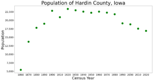
Demographics is the study of people in a certain area. It looks at things like how many people live there and what groups they belong to.
| Historical population | |||
|---|---|---|---|
| Census | Pop. | %± | |
| 1860 | 5,440 | — | |
| 1870 | 13,684 | 151.5% | |
| 1880 | 17,807 | 30.1% | |
| 1890 | 19,003 | 6.7% | |
| 1900 | 22,794 | 19.9% | |
| 1910 | 20,921 | −8.2% | |
| 1920 | 23,337 | 11.5% | |
| 1930 | 22,947 | −1.7% | |
| 1940 | 22,530 | −1.8% | |
| 1950 | 22,218 | −1.4% | |
| 1960 | 22,533 | 1.4% | |
| 1970 | 22,248 | −1.3% | |
| 1980 | 21,776 | −2.1% | |
| 1990 | 19,094 | −12.3% | |
| 2000 | 18,812 | −1.5% | |
| 2010 | 17,534 | −6.8% | |
| 2020 | 16,878 | −3.7% | |
| 2023 (est.) | 16,463 | −6.1% | |
| U.S. Decennial Census 1790-1960 1900-1990 1990-2000 2010-2018 |
|||
2020 Census Information
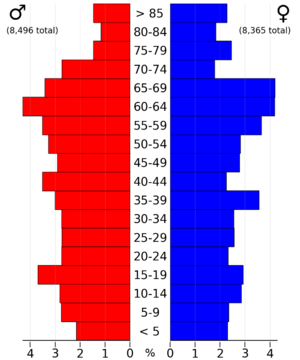
The 2020 census counted 16,878 people living in Hardin County. This means there were about 30 people living in each square mile. Most people (95.71%) said they belonged to one race. There were 8,032 homes, and 7,070 of them were lived in.
| Race | Num. | Perc. |
|---|---|---|
| White (NH) | 15,292 | 90.6% |
| Black or African American (NH) | 144 | 0.9% |
| Native American (NH) | 25 | 0.15% |
| Asian (NH) | 86 | 0.51% |
| Pacific Islander (NH) | 2 | .01% |
| Other/Mixed (NH) | 511 | 3.03% |
| Hispanic or Latino | 818 | 5% |
Communities in Hardin County
Hardin County has many different towns and cities.
Cities
Census-Designated Place
Other Small Communities
These are smaller places that are not officially cities:
Townships
A township is a small area of land, usually with a local government. Hardin County has these townships:
- Alden
- Buckeye
- Clay
- Concord
- Eldora
- Ellis
- Etna
- Grant
- Hardin
- Jackson
- Pleasant
- Providence
- Sherman
- Tipton
- Union
Population Ranking of Communities
This table shows the communities in Hardin County, ranked by how many people lived there in 2020.
† county seat
| Rank | City/Town/etc. | Municipal type | Population (2020 Census) |
|---|---|---|---|
| 1 | Iowa Falls | City | 5,106 |
| 2 | † Eldora | City | 2,663 |
| 3 | Ackley (partially in Franklin County) | City | 1,599 |
| 4 | Hubbard | City | 860 |
| 5 | Alden | City | 763 |
| 6 | Radcliffe | City | 555 |
| 7 | Union | City | 399 |
| 8 | Steamboat Rock | City | 264 |
| 9 | New Providence | City | 236 |
| 10 | Whitten | City | 100 |
| 11 | Garden City | CDP | 100 |
| 12 | Buckeye | City | 86 |
| 13 | Owasa | City | 34 |
See also
 In Spanish: Condado de Hardin (Iowa) para niños
 | Bayard Rustin |
 | Jeannette Carter |
 | Jeremiah A. Brown |


