Hamilton County, Iowa facts for kids
Quick facts for kids
Hamilton County
|
|
|---|---|

Hamilton County Courthouse
|
|

Location within the U.S. state of Iowa
|
|
 Iowa's location within the U.S. |
|
| Country | |
| State | |
| Founded | 1856 |
| Named for | William W. Hamilton |
| Seat | Webster City |
| Largest city | Webster City |
| Area | |
| • Total | 578 sq mi (1,500 km2) |
| • Land | 577 sq mi (1,490 km2) |
| • Water | 0.8 sq mi (2 km2) 0.1% |
| Population
(2020)
|
|
| • Total | 15,039 |
| • Estimate
(2023)
|
14,729 |
| • Density | 26.019/sq mi (10.046/km2) |
| Time zone | UTC−6 (Central) |
| • Summer (DST) | UTC−5 (CDT) |
| Congressional district | 4th |
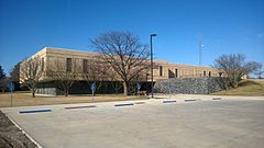
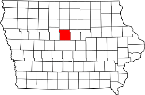
Hamilton County is a special area in the state of Iowa, USA. It's like a big neighborhood with its own local government. In 2020, about 15,039 people lived here. The main town, or county seat, is Webster City. This county was named after William W. Hamilton, who was an important leader in the Iowa State Senate a long time ago.
Contents
Exploring Hamilton County's Land
Hamilton County covers a total area of about 578 square miles. Most of this is land, around 577 square miles. A small part, about 0.8 square miles, is water. The biggest lake in the county is Little Wall Lake.
Main Roads and Highways
These are the important roads that help people travel through Hamilton County:
 Interstate 35
 U.S. Highway 20
 U.S. Highway 69
 Iowa Highway 17
 Iowa Highway 175
Neighboring Counties
Hamilton County shares its borders with several other counties:
- Wright County (to the north)
- Hardin County (to the east)
- Story County (to the southeast)
- Boone County (to the southwest)
- Webster County (to the west)
Who Lives in Hamilton County?
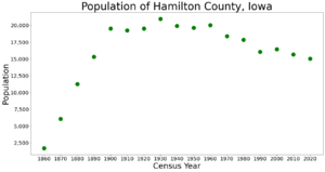
We can learn about the people in Hamilton County by looking at information from the U.S. Census. This count happens every ten years.
| Historical population | |||
|---|---|---|---|
| Census | Pop. | %± | |
| 1860 | 1,699 | — | |
| 1870 | 6,055 | 256.4% | |
| 1880 | 11,252 | 85.8% | |
| 1890 | 15,319 | 36.1% | |
| 1900 | 19,514 | 27.4% | |
| 1910 | 19,242 | −1.4% | |
| 1920 | 19,531 | 1.5% | |
| 1930 | 20,978 | 7.4% | |
| 1940 | 19,922 | −5.0% | |
| 1950 | 19,660 | −1.3% | |
| 1960 | 20,032 | 1.9% | |
| 1970 | 18,383 | −8.2% | |
| 1980 | 17,862 | −2.8% | |
| 1990 | 16,071 | −10.0% | |
| 2000 | 16,438 | 2.3% | |
| 2010 | 15,673 | −4.7% | |
| 2020 | 15,039 | −4.0% | |
| 2023 (est.) | 14,729 | −6.0% | |
| U.S. Decennial Census 1790-1960 1900-1990 1990-2000 2010-2018 |
|||
What the 2020 Census Shows
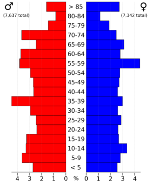
The 2020 census counted 15,039 people living in Hamilton County. This means there were about 26 people per square mile. There were 7,037 homes, and 6,283 of them were lived in.

Here's a look at the different groups of people in Hamilton County from the 2020 census:
| Race | Number of People | Percentage |
|---|---|---|
| White | 12,702 | 84.46% |
| Black or African American | 88 | 0.6% |
| Native American | 25 | 0.16% |
| Asian | 314 | 2.1% |
| Pacific Islander | 0 | 0% |
| Other/Mixed | 445 | 3% |
| Hispanic or Latino | 1,465 | 9.74% |
What the 2010 Census Showed
In 2010, the census counted 15,673 people in Hamilton County. There were 7,219 homes, and 6,540 of them were lived in.
Towns and Communities
Hamilton County has several towns and smaller communities where people live.
Cities in Hamilton County
Smaller Communities (Unincorporated)
- Homer
Local Areas (Townships)
These are smaller areas within the county, often named after early settlements or features.
- Blairsburg
- Fremont
- Cass
- Williams
- Freedom
- Independence
- Rose Grove
- Webster
- Hamilton
- Lyon
- Lincoln
- Marion
- Clear Lake
- Ellsworth
- Scott
- Liberty
How Big Are the Cities?
This table shows the population of the cities in Hamilton County, based on the 2020 census. The county seat (main town) is marked with a dagger (†).
| Rank | City/Town/etc. | Type of Place | Population (2020 Census) |
|---|---|---|---|
| 1 | † Webster City | City | 7,825 |
| 2 | Jewell Junction | City | 1,216 |
| 3 | Stratford (partially in Webster County) | City | 707 |
| 4 | Ellsworth | City | 508 |
| 5 | Stanhope | City | 364 |
| 6 | Williams | City | 307 |
| 7 | Kamrar | City | 179 |
| 8 | Blairsburg | City | 176 |
| 9 | Randall | City | 154 |
Schools in Hamilton County
Kids in Hamilton County go to schools that are part of different school districts. Here are some of them:
- Hubbard-Radcliffe Community School District
- Roland-Story Community School District
- South Hamilton Community School District
- Stratford Community School District
- Webster City Community School District
Some school districts that used to exist are:
- Northeast Hamilton Community School District
Images for kids
See also
 In Spanish: Condado de Hamilton (Iowa) para niños
 | Kyle Baker |
 | Joseph Yoakum |
 | Laura Wheeler Waring |
 | Henry Ossawa Tanner |


